Low-Impact Developement Planting Guide

Download Planting Guides and Plant Lists
Adapted from "Developing Educational Tools for Sustainable Stormwater Management." Find the full report here.
Stormwater & Low-Impact Development in Arid Regions & Utah
Rapid population growth and development is placing pressure on the limited water resources in Western states. Urbanization increases impervious surfaces preventing precipitation from infiltrating into the ground effectively, which results in changes to hydrologic conditions with higher runoff volumes and higher peak flows. Stormwater flows across impervious surfaces transporting urban pollutants and discharging them into receiving waters. As cities grow, the amount of pollution entering waterways increases in turn. A rapid transition from undeveloped to developed environments is occurring across the state of Utah.
In Utah, natural landscapes and agricultural lands are being developed rapidly to accommodate population growth. Undeveloped areas have natural ground cover, including soil and plants to help infiltrate water and decrease the amount of runoff that leaves a site during precipitation events (Figure 1). Plants use a portion of the water, then transpire and evaporate the rest back into the surrounding environment in a process known as evapotranspiration. In arid and semi-arid climates, evapotranspiration accounts for the highest percentage of water leaving an undeveloped, natural system. A much smaller portion of water is stored in soil or infiltrates down to recharge ground aquifers. Only a small percentage of water leaves a site as runoff. In undeveloped watersheds, runoff gradually drains across the landscape to waterways.
In developed areas, much of the natural ground cover is replaced with impervious surfaces such as roads, rooftops, and parking lots. Precipitation cannot easily soak through impervious surfaces causing more water to leave the system as runoff, while the decrease in vegetation results in a loss to total evapotranspiration (Figure 1).
Figure 1. Magnitude of hydrologic pathways in undeveloped and urban land uses in arid regions.
Many urban watersheds use traditional “collect-and convey” pipe drainage systems, which carry large volumes of stormwater directly to surface waters, often without any form of water treatment. Precipitation falls on impervious surfaces, then flows to pipes or drains in designated collection areas. The water is either piped directly to outlets in waterbodies or injected into stormwater collection systems underground. Water that is not captured by these systems, infiltrated into the ground, or evaporated flows across impervious surfaces eventually entering waterways as urban runoff.
The hydrologic impacts of urbanization are well-documented, including higher runoff volumes and more frequent and higher peak flows (D.B. Booth, 1997; Konrad & Booth, 2002). Higher runoff volumes send pulses of energy through a system increasing stream channel erosion and pollutant loading. Stormwater runoff flows quickly over impervious surfaces picking up and discharging urban pollutants—such as oils, chemicals, sediment, microplastics, and organic materials that impair water quality—into surface waters.
Benefits of LID
A low-impact development (LID) approach to stormwater management aims to mimic predevelopment hydrologic conditions and utilizes stormwater as a resource to retain precipitation onsite longer. Low-impact development techniques are used to improve infiltration, evapotranspiration, and the harvesting and/or reuse of runoff. The focus of LID practices is to preserve, restore, and create green spaces using regional and site-specific soils and vegetation to help capture and collect stormwater.
Using LID practices reduces development impacts, while restoring natural hydrologic conditions and providing aesthetic benefits. The use of LID provides many benefits, including lower runoff volumes and peak flows, less impervious surfaces, more vegetation, fewer pipes and underground stormwater infrastructure, better water quality and habitat protection, decreases in the urban heat-island effect, and less erosion of stream channels.
Urban environments in the southwestern U.S. have a small but disproportionate impact on water quality relative to their size (Gallo et al., 2012; Grimm et al., 2008). Urban runoff is considered one of the leading sources of anthropogenic water quality impairment behind agricultural runoff. The volume of runoff discharged into urban-interfacing waterbodies creates significant water quality issues. Properly managing stormwater in water-limited landscapes is crucial for long-term water quality and habitat protection. Many Utah counties are experiencing, or soon will be, the growing challenge of stormwater management as more landscapes transition from undeveloped to developed. Implementing sustainable stormwater management practices, such as LID in areas expected to see exponential growth in the next 25 years is critical to avoid the expensive and difficult task of restoring impaired waters.
Benefits of Vegetation in LID Design
Vegetation is an important part of the success of BMPs. Plants can be selected to provide specific benefits such as pollutant uptake, erosion protection, increased percolation, wildlife habitat, aesthetic appeal, and heat reduction.
Table 1. Adapted from DWQ’s LID Manual (“A Guide to LID,” 2020, pgs. 39-40)
|
Benefit |
Purpose |
|
Pollutant Reduction |
|
|
Protects Soil from Erosion |
|
|
Increase Percolation Rates |
|
|
Wildlife Habitat |
|
|
Aesthetics/Mental Health |
|
|
Heat Reduction |
|
Vegetation Considerations
There are many factors that can influence the establishment and longevity of plants used with LID practices. Some of the most important factors to consider include site conditions and a plant’s adaptability to various conditions, water needs, soil needs, ability to tolerate pollutants, heat, cold, wind, flooding, and drought.
Site and Growing Conditions
It is important to match the needs of selected plants to site conditions. Urban environments can create microclimates when sunlight and heat absorb into roadways and reflect off pavement, concrete, and glass. Increasing temperatures due to the urban heat island effect can cause increases in evapotranspiration rates. Development disturbs soils causing changes in natural drainage patters and soil porosity and structure. Plants need to be tolerant of and adaptable to changing site conditions due to urban pollution (e.g., salts, poor air quality, grease, etc.), temperature fluctuations, and nutrient and water availability. Native species are a good choice because they are better adapted to changing site conditions, but plants that are highly tolerant of a variety of soils and frequent water and temperature changes may also be suitable.
Water Needs
In arid to semi-arid climates, such as Utah, a plant’s water needs and ability to withstand periods of drought is particularly important. Fluctuation in soil moisture is common in desert environments. This should be taken into consideration as plants that can adapt to wide fluctuations in soil moisture will be better suited to Utah’s climate. Additionally, water restrictions are common during periods of drought. Plants that need less water or that are tolerant of drought will be less stressed as well as conserve water. On the other hand, plants that can withstand saturated soils, flooding, and ponding are well suited to LID practices designed to increase stormwater infiltration rates.
Soil Needs
Plants have soils preferences including consistency, drainage, and pH. It is important to consider these factors when selecting plants for a site. Natural and/or engineered soils may need to be enhanced to help plants establish and succeed. Some plants are nitrogen fixers and can work symbiotically with soil microbes to improve soil naturally. Soil porosity and structure will impact drainage and infiltration. Soil structure also impacts plants’ root systems and ability to withstand various stormwater volumes and velocities.
Pollution Tolerance
Tolerance to salts is an important factor in plant selection for urban environments. Some plants prefer slightly saline environments and are good choices for LID practices in sites where salt concentrations are higher in stormwater runoff.
Air pollution tolerance should also be considered. Some plants prefer environments with higher carbon concentrations and would be ideal for urban areas. Plants can also play an role in CO2 sequestration.
Heat, Cold, and Wind Tolerance
A plant’s ability to survive local climate is key to its survival. Selected plants should be adapted to or tolerant of seasonal temperature changes, including maximum and minimum temperatures, and exposure to direct sun, frost, snow, and wind. The DWQ has developed a map of plant hardiness zones that labels areas in Utah according to their lowest annual minimum temperature. Plants should only be grown in their identified hardiness zones. Find the map in the PDF version of this planting guide.
Heat tolerance is also an important factor in plant survival. Consider the average number of days the site location experiences extreme heat when selecting plants. The urban heat island effect, as well as impervious and reflective surfaces, may exacerbate temperatures on site. Drought conditions and increased evapotranspiration will play a larger role in especially hot and dry desert regions.
The Utah DWQ recommends the following steps when selecting vegetation for specific LID BMP types (“A Guide to LID,” 2020, pg. 44):
- Consider consulting relevant professionals such as engineers, landscape architects, and/or horticulturalists to help select plants and design each BMP.
- Identify the hardiness zone(s) at the site.
- Identify which BMPs will be used.
- Determine if there are any microclimates within the site that need to be considered.
- Identify plants that will best work for the BMP based on the hardiness zone and site’s microclimates.
- Develop a landscape plan that considers site conditions, erosion protection, pollutant mitigation, human use of and interaction with the site, creation of wildlife habitat, aesthetics, and site and BMP maintenance.
LID Planting Guide Development
The purpose of this planting guide is to help stormwater professionals select the best plants for the LID-type they are designing as well as the plant’s desired benefits and qualities. This guide was designed to supplement the Utah Division of Water Quality’s “Utah Plant Selection Matrix by Climate Zone and BMP” list included in their LID manual called “A Guide to Low Impact Development within Utah.”
Below you will find the full planting guide as well as each guide broken down into LID type with the corresponding plants lists. Additionally, there is information about planting zones and a key to help understand the symbology in the plants lists.
You can also download the full spreadsheet that can be filtered to sort plants by plant type, soil type, water needs, sunlight requirements, growth rate, and plant tolerances.
Download Planting Guides
 Full LID Planting Guide & Plant Lists
 Sortable Spreadsheet - Plant Lists by LID Type
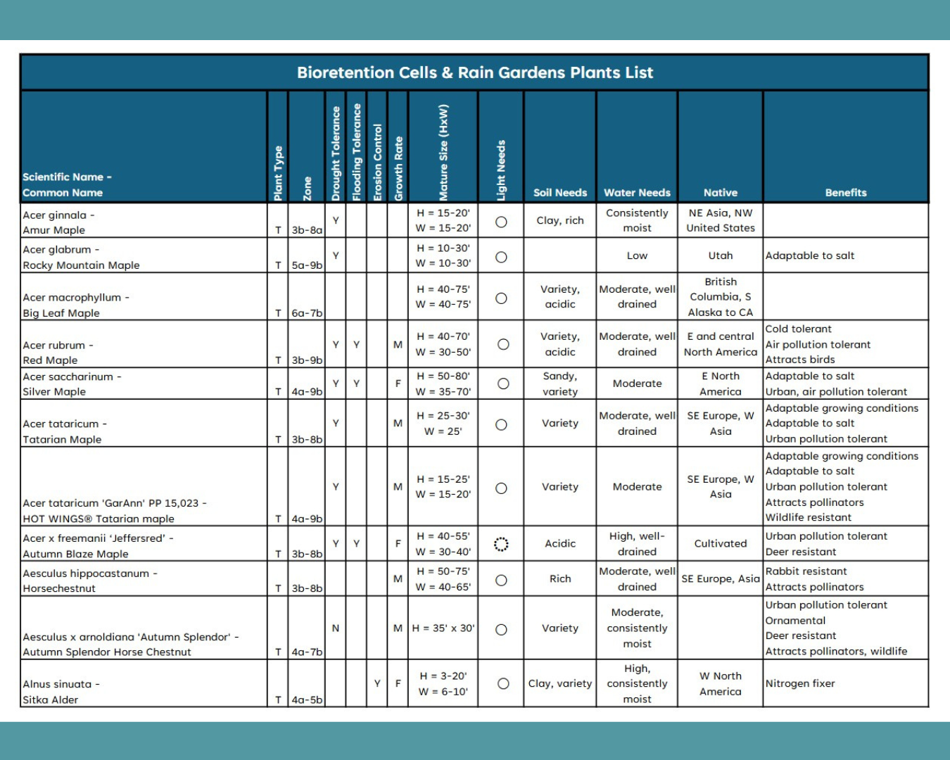
 Bioretention Cells & Rain Gardens Planting Guide
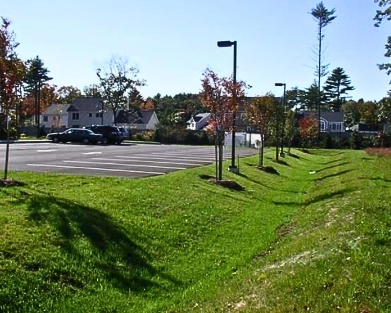 Vegetated Strips Planting Guide
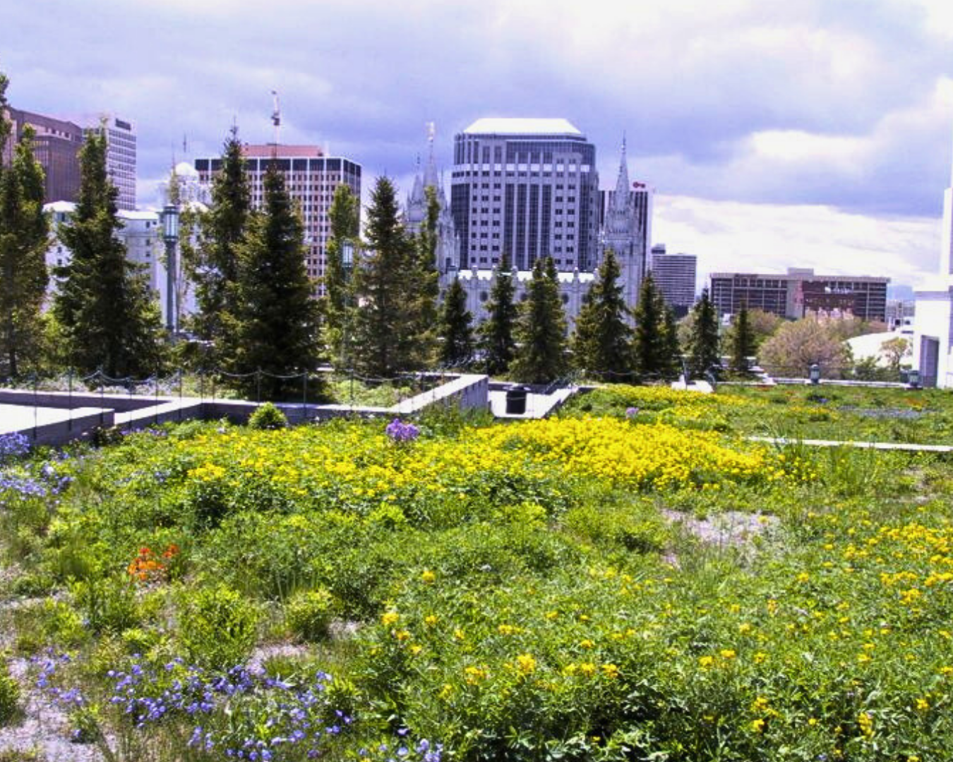 Green Roofs Planting Guide
 Tree Box Filters Planting Guide
References
Colorado State University, Denver Botanical Gardens. (n.d.). Our Plants [Database]. Plant Select. https://plantselect.org/plants/our-plants/
EPA. (n.d.). [Image of rain garden from the New Belgium Brewery in Fort Collins, Colorado]. Retrieved from https://www.epa.gov/green-infrastructure/green-infrastructure-semi-arid-west
Houskeeper, Lauren, "Developing Educational Tools for Sustainable Stormwater Management" (2024). All Graduate Reports and Creative Projects, Fall 2023 to Present. 37. https://digitalcommons.usu.edu/gradreports2023/37
Jordan Valley Water Conservancy District. (n.d.). Find Waterwise Plants [Database]. Conservation Garden Park. https://conservationgardenpark.org/plants
Missouri Botanical Garden. (n.d.). Plant Finder [Database]. https://www.missouribotanicalgarden.org/PlantFinder/plantfindersearch.aspx
Monrovia Nursery Company. (n.d.). Browse All Plants [Database]. Monrovia. https://www.monrovia.com/shop.html?productFilter=
NC State University. (n.d.) North Carolina Extension Gardner Plant Toolbox [Database]. NC State Extension. https://plants.ces.ncsu.edu/find_a_plant/
Oakland Nurseries. (n.d.) Plant Finder [Database]. https://plants.oaklandnursery.com/12130001
Plants for a Future. (n.d.). Database Plant Search [Database]. https://pfaf.org/user/
Sandy City Public Utilities. (2021). Sandy City Low Impact Development Toolbox. [Image of vegetated strip near parking lot]. Retrieved from https://content.civicplus.com/api/assets/a3d38a2b-4511-49f8-9245-ada2d0421069
Utah Division of Water Quality. (2020). A Guide to Low Impact Development within Utah [Image of vegetated strip]. Utah Department of Environmental Quality. https://documents.deq.utah.gov/water-quality/stormwater/updes/DWQ-2019-000161.pdf
Utah Division of Water Quality. (n.d.). [Image of bioretention cell in North Salt Lake]. Retrieved from https://deq.utah.gov/wp-content/uploads/Bioretention-Cell-North-Salt-Lake-Large.jpg
Utah Division of Water Quality. (2020). A Guide to Low Impact Development within Utah [Manual PDF]. Utah Department of Environmental Quality. https://documents.deq.utah.gov/water-quality/stormwater/updes/DWQ-2019-000161.pdf
Utah Division of Water Quality. (2020). Plant Hardiness Zones [Map]. Utah Department of Environmental Quality. https://documents.deq.utah.gov/water-quality/stormwater/updes/DWQ-2019-000161.pdf
Utah State University. Range Plants of Utah [Database]. Utah State University Extension. https://extension.usu.edu/rangeplants/
Utah State University. TreeBrowser [Database]. Utah State University Extension. https://extension.usu.edu/treebrowser/
Utah State University Extension Photo Gallery. (n.d.). [Photo database]. Retrieved from https://extension.usu.edu/employee/marketing/photos/multimedia-specialist
Authors
Lauren Houskeeper, Science Communicator, Environmental Educator
Erin Rivers, Water Quality Extension and Stormwater Specialist