Precision Irrigation for Center Pivots Quickguide
Precision irrigation is a process involving technology and specialized equipment to improve the efficiency and effectiveness of agriculture irrigation management by allocating water based on topography, yield, and soil properties throughout fields and can sometimes conserve water and improve crop quality. Variable rate irrigation (VRI) is a technology used on agricultural irrigation systems to vary the water application rate and/or speed of the irrigation to cater to the different needs throughout a field.
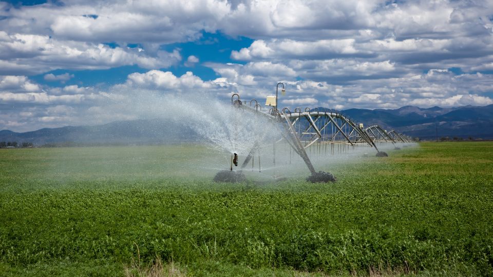
Speed Control VRI Systems
Allow the pivot to run at different speeds throughout the field, creating pie-shaped zones. The flow rate is not modified.
- Lower upfront cost, less technology used, and fewer equipment changes.
- Easy to learn and less skills required.
- Useful for areas with moderate variability.
- Can only apply in pie-shaped wedges.
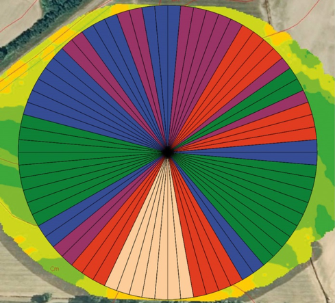
Zone Control VRI Systems
Adjust the pivot speed as well as the watering rates along the pivot. Provides much more potential spatial variability in irrigation rates.
- Higher upfront cost, more technology and maintenance.
- More technical skills needed.
- More precise.
- Better at responding to spatial variation in fields.
Irrigation needs throughout a field typically are not uniform due to multiple reasons, such as varying soil textures that require different amounts of irrigation to reach field capacity; varying soil water properties, topography changes resulting in ridges and swells where runoff and ponding may occur; rock outcroppings and areas with less topsoil, which result in lower crop productivity and reduced water needs. Setting the prescription or variable irrigation map is one of the most important features of VRI systems and methods for setting these maps vary greatly. Maps are commonly created using soil texture and water property, apparent electrical conductivity, and elevation data. Yield maps, drone imagery, and evapotranspiration data can also be used depending on the field need and VRI system used.
Utah State University is an affirmative action/equal opportunity institution and is committed to a learning and working environment free from discrimination, including harassment. For USU’s non-discrimination notice, see equity.usu.edu/non-discrimination
References
Authors
Katelyn Parker, Elisa Flint, Matt Yost, Troy Peters, Clara Anderson, Burdette Barker, and Neil Hansen