Mobile Location Analytics
Land managers are increasingly using electronic data as a cost-effective way to determine data about parks and protected areas. As this technology becomes the norm, important questions surface: How accurately does geotagged data reflect visitation? How can this type of information be most effectively used in management? We perform research and analysis to help managers navigate this new strategy.
Mobile Location Analytics
services
iort
Visitor Use Monitoring and Management
Are the specific locations that drive Utah’s tourism economy? We use millions of social media posts to determine the exact geographic locations most visited by travelers to provide an accurate, scientifically-defensible understanding of these destinations
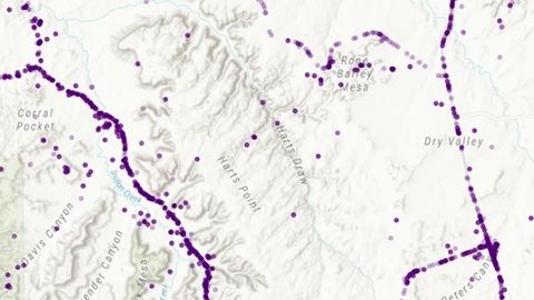
Mapping Utah's Most Visited Places
Mapping Utah's Most Visited Places
Are the specific locations that drive Utah’s tourism economy? We use millions of social media posts to determine the exact geographic locations most visited by travelers to provide an accurate, scientifically-defensible understanding of these destinations...