Keeping National Parks Healthy with NRCA Support
National Parks are furiously photographed – millions of images already exist of sandstone hoodoos, placid lakes and sun-dappled wildflowers within National Park Service (NPS) boundaries. But Mark Brunson is working on another kind of snapshot. He holds NPS lands up to a spotlight of sorts, capturing information for a given moment in time about their conditions – from views of the night sky to mercury pollution to animal populations. Brunson leads a team that performs Natural Resource Condition Assessments (NRCAs) in National Park units across the West.
The mandate for the National Park Service is admittedly tricky. NPS managers are charged with both protecting natural resources and providing the public the opportunity to enjoy them. Managers have to consider everything from ozone levels to blue-gray gnatcatcher populations when evaluating the health of the lands they oversee. With limited staff and budgets, managers are asked to prioritize the protection of the important values that define their park. The question is … how do they (and we) know if they are succeeding?
With the NRCA program, Brunson and his team help managers pinpoint important natural resources and canary-in-the-mine indicators in places like Golden Spike National Historic Park, Little Bighorn Battlefield National Monument and Bryce Canyon National Park. They provide a science-based look at conditions on each unit – what resources seems to be in good shape, and which are potentially threatened.
"Protection of natural resources often overlaps with cultural and historic resources,” said Brunson. “At Golden Spike National Historic site, everyone thinks about the railroad as the main resource to protect. But the natural environment there contains a lot of context about the history of the place … part of understanding that experience is understanding the environment in which the Chinese workers had to endure. The natural conditions helps the history to come alive for the visitor.”
Brunson and his team – coordinator Kim Struthers and science writer Lisa Baril, have already completed assessments for 25 different National Park Service units across the U.S. including Bryce Canyon and Cedar Breaks in Utah. They are now launching a new study for Glen Canyon National Recreation Area.
Sometimes their considerations go beyond park boundaries. At Saguaro National Park, managers voiced concerns that animals like bobcats didn’t have the space they needed to travel within their territory for hunting and mating. The team looked at mammal corridors between Ironwood Forest National Monument and Saguaro National Park as part of their evaluation.
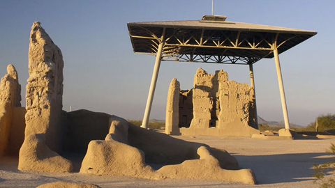
At another site – Casa Grande Ruins National Monument – managers noticed that surrounding development was pushing small rodents in greater concentrations into park boundaries. This influx of animals was affecting their cultural resources (the reason why the monument was established in the first place). The rodents’ increased levels of burrowing was moving artifacts like pottery shards and ancient tools around, losing some location context for archeological purposes. Managers at Casa Grande were interested in knowing more about small mammal populations, in part, because it would help them understand more about what they might do to protect the cultural resources.
“A big part of what we do is to help managers identify knowledge gaps … areas they may not know that they don’t know anything about,” said Brunson. This process is intended as a tool to help them plan and develop long-term strategies, he said.
The team is also working on ways to make the information that comes out of the process even more user friendly and easy to implement into management. At Valles Caldera National Preserve in New Mexico, the team is working with NPS staff to produce communication products about Jemez Mountains salamander and high alpine systems on Redondo Peak that are helpful not only to managers, but for consumption by the public.