Sagebrush, Wildfire, and Homeowners Associations: Climate Adaptation Opportunities in Summit County, Utah
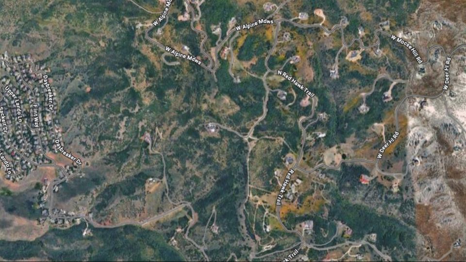
Source: Google Maps, n.d.
Environmental changes and rapidly expanding suburban developments are amplifying wildfire risk in Utah, including in mixed-sagebrush habitats like those in Morgan, Summit, and Wasatch counties along the Wasatch Back. Wildfire risk to people and structures is especially high in the wildland-urban interface (WUI), where homes and buildings intermingle with undeveloped wildlands and natural vegetation that can fuel wildfire (Figure 1). Much of this urban expansion is occurring in the form of large, dispersed developments managed by homeowners associations (HOAs), which often dictate standards for the homes and properties within their purview. Thus, HOAs can play a critical role in supporting wildfire mitigation efforts in the WUI. To this end, strategies HOAs can implement include: (1) creating and maintaining defensible space and entrance/exit routes to communities, (2) managing fuels to prevent or slow the invasion of highly flammable annual grasses like cheatgrass, and (3) using strategic grazing or other tools such as chemical treatments to reduce fuels where annual grasses have already invaded sagebrush habitat.
Sagebrush in Summit County
About 20% of Utah, including parts of Summit County, is sagebrush shrub–steppe (Birch & Lutz, 2023). This ecosystem type is common in the Great Basin and Colorado Plateau. In these regions, sagebrush plays an important ecological role by supporting wildlife and slowing the melt of winter snowpack, making it a conservation priority (Kormos et al., 2017; Remington et al., 2024). While sagebrush habitats historically (i.e., pre-1850) burned every 35–450 years, contemporary climate change, loss of native bunchgrasses, and invasion of annual grasses are increasing the frequency and severity of wildfire, which is particularly problematic due to new human developments in the area (Figure 2; Baker, 2006; Miller et al., 2011).
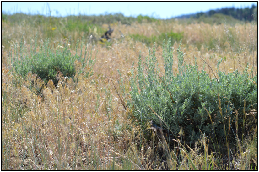
Source: Strickland, 2017 CC-BY-2.0
Cheatgrass (Bromus tectorum) is an invasive annual grass of particular concern because it is widespread and reproduces rapidly, especially where clumps of native bunchgrasses have been depleted by grazing (Miller et al., 2011). While sagebrush shrubs and native bunchgrasses typically maintain space between plants, cheatgrass forms a continuous fuel bed that facilitates fire spread. Moreover, cheatgrass, a cool-season grass, matures early in the growing season and then dries out, so the continuous fuel bed is flammable for a longer period. Typically, cheatgrass recovers within 2 years after fire, but sagebrush shrubs can take 3–12 decades to reestablish (Baker, 2006; Grant-Hoffman & Plank, 2021). In some areas where cheatgrass now dominates, fire frequency has increased dramatically. For example, as of 1990, heavily invaded pockets of sagebrush in the Snake River Plain of Wyoming were burning every 5 years (Miller et al., 2011).
In Utah, over 1.9 million acres of sagebrush habitat burned from 1984–2022, with 25% of that area burning at high severity (Birch & Lutz, 2023). Of the 1,477 wildfires larger than 100 acres that burned in Utah during this period, sagebrush was present in 96% of them (Birch & Lutz, 2023). The higher severity and large size of recent wildfires in sagebrush habitat could be due to existing invasions of annual grasses, which have been considered problematic in the western U.S. since at least 1941 (Remington et al., 2024).
Within sagebrush habitat, a cheatgrass-wildfire cycle exists where wildfire facilitates the spread of cheatgrass, which in turn increases wildfire risk. As of 2024, many areas in western Utah that burned in the past four decades are designated “containment” zones, where invasive annual grasses are so well-established that restoration to native bunchgrasses is no longer realistic (Birch & Lutz, 2023; Boyd et al., 2024). However, the northern region of Summit County near Castle Rock still contains intact sagebrush habitat. Here, early detection and removal of invasive grasses remains the recommended conservation strategy (Boyd et al., 2024). In addition, several other areas near Castle Rock and Echo have only moderate invasions, and suppressing invasives and restoring perennial bunchgrasses are recommended (Boyd et al., 2024). Cheatgrass has likely been slower to invade Summit County because of the cooler temperatures and longer period of snow cover at higher elevations. However, as native vegetation––even at higher elevations––is increasingly stressed by earlier snowmelt, prolonged drought, and wildfire due to climate change, spread of cheatgrass may accelerate in Summit County (Becker & Hotaling, 2024). Indeed, cheatgrass has already been observed in Summit County in the footprint of the 2018 Tollgate Canyon Fire and along the roads and highways in the Park City area (elevation 6,980 feet), where vehicles, mountain bikes, and hiking shoes can transport seeds.
What Is the Wildland-Urban Interface?
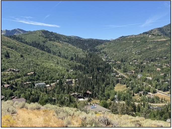
Photo: J. Bradley Washa
Summit County and much of its developed area are located in the WUI (Figure 3). As mentioned, the WUI refers to areas where human developments abut undeveloped forests or rangelands with fire-prone vegetation (FEMA Geospatial Resource Center, 2023). Vegetation that grows in the WUI historically depended on periodic fire to keep the ecosystems healthy. For example, low-severity fires in intact sagebrush habitats can keep juniper and pinyon pine from expanding and changing the habitat type (McGinty & McGinty, 2009). However, fires also put homes and infrastructure occupying the same areas at risk.
As climate change lengthens the wildfire season further into spring, fall, and even winter, interactions between human communities and wildfire have become increasingly catastrophic (Wasserman & Mueller, 2023; Washa, 2025). For example, in January 2025, wildfires spread from the WUI into urban areas of Los Angeles County, killing 29 people, destroying over 16,000 structures, and causing an estimated $76–$131 billion of damage (Li & Yu, 2025). In Utah, wildfire has been the most expensive natural hazard since 2020 and, between 1980 and 2024, it accounted for 39% of the total cost of billion-dollar, climate-related disasters in the state (Flavelle & Rojanasakul, 2024; National Centers for Environmental Information, 2025).
Homeowners Associations in Summit County
Summit County is just east of Salt Lake City, Utah, and neighbors Wyoming. Home to about 43,000 people, Summit County contains important Utah landmarks such as Park City, a site of the 2002 and 2034 Winter Olympics with numerous tourist attractions (United States Census Bureau, 2024). As the populations of Utah, the Wasatch Back, and Summit County continue to grow, housing developments are spreading into the WUI (Figures 1 and 3). Often, HOAs manage these neighborhoods (iPropertyManagement, 2025).
HOAs are private organizations that manage and maintain residential communities, typically in planned developments, condominiums, or subdivisions. The primary purpose of HOAs is to preserve property values and enhance communities through enforcing governing codes called covenants, conditions, and restrictions (CC&Rs; Loftsgordon, 2024). HOAs collect dues from homeowners to fund community maintenance, including common areas, amenities, and infrastructure. They also establish and enforce architectural guidelines to maintain aesthetic consistency, mediate disputes between residents, and often organize community events to foster neighborhood relationships. HOAs are typically governed by a board of directors who are elected by community members and make decisions regarding budgeting, rule enforcement, and community improvements, all to create and maintain a desirable living environment for residents (Chen, 2024). With these responsibilities, many HOAs on the Wasatch Back have focused on reducing the risk of wildfire, which should be a natural goal of all HOAs in the region.
Home Insurance and Wildfire Risk
Home insurance premiums and policy availability can also motivate HOAs and individuals to reduce wildfire risk. Typically, HOAs are responsible for insuring common spaces within the development, and homeowners are responsible for purchasing their own home insurance policies. Wildfire risk can increase insurance premiums and even cause insurance companies to cancel policies and stop issuing new ones, which has already begun happening in the Wasatch Back (Keys & Mulder, 2024; Li & Yu, 2025). Uninsured homes are typically ineligible for a mortgage, limiting ownership to those who can afford to buy with cash and who are willing to assume the full risk of an uninsured property (Keys & Mulder, 2024). Expensive or nonexistent home insurance may decrease demand for those homes and ultimately lower their value––an outcome contrary to HOA goals.
Both statewide and in Summit County, home insurance premiums have increased in recent years. On average, median home insurance premiums in Utah rose 52.3% from 2020 to 2023 (Lambert, 2024). The increase in Summit County, at 96.8%, far outpaced this statewide rate and was the second highest increase after Grand County (154.4%) where the city of Moab is located (Lambert, 2024). Part of the increase in premiums was due to inflation, which totaled about 19% during the same period (U.S. Bureau of Labor Statistics, n.d.). However, the remainder––and bulk of the increase––was likely driven by two additional factors: (1) higher home values, and (2) greater risk of wildfire and other climate-driven disasters (Keys & Mulder, 2024). Still, despite the higher premiums, insurance companies in Utah sustained losses in 2023 (Flavelle & Rojanasakul, 2024). This suggests that insurance premiums are likely to continue increasing, and effective wildfire mitigation may be needed to keep premiums affordable and encourage insurance companies to continue offering policies. Risk of home loss is a growing concern in Utah, not only for those suffering losses, but also for all levels of government and the insurance industry. The state of Utah is working to address this concern with House Bill 48 Wildland Urban Interface Modifications, which includes provisions related to insurance and building codes for WUI properties.
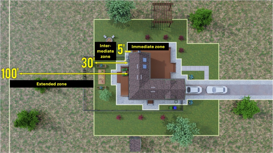
Source: Cal FIRE, 2024a
Sagebrush, Wildfire Risk, and Management Strategies
Maintain the Natural Sagebrush Ecosystem
While sagebrush habitat can pose a wildfire risk that escalates with annual grass invasion, maintaining sagebrush has multiple benefits:
- Sagebrush provides habitat for native animal species, including bees, sage-grouse, small mammals, and big game (Cane & Love, 2016; Remington et al., 2024). It also provides valuable rangeland for cattle grazing (Davies et al., 2024).
- Sagebrush helps sustain water supply for animals and people. Compared with juniper-dominated rangelands, snowpack in intact sagebrush melts out 9 days later on average and supports higher streamflow (Kormos et al., 2017).
- Sagebrush maintains ecosystem integrity. Its degradation or removal invites the rapid establishment of invasive grasses such as cheatgrass, which increases the risk of wildfire. Thus, removing sagebrush puts communities at risk because it could be replaced by more flammable, invasive vegetation (Harrison, 2024; Remington et al., 2024).
Steps can be taken, however, at the community and household levels to prevent the spread of wildfire while preserving Summit County’s natural sagebrush ecosystem.
Establish Defensible Space
Creating “defensible space” around neighborhoods and individual homes is one recommended strategy. Defensible space refers to a series of buffer zones, referred to as the Home Ignition Zone, between a property and the surrounding wildland area (Figure 4; Cal FIRE, 2024a). The premise is to start at the home and manage vegetation outward, reaching to 100 feet and potentially beyond. Vegetation closer to the home should be more heavily managed (Cal FIRE, 2025a). Part of this management should include fuel reduction, or the removal of combustible vegetation, including dead weeds, grass, and debris. This is vital to slowing the spread of wildfire and protecting homes from stray embers, flames, and heat. Fuel reduction also helps firefighters. When firefighters have a safe area from which to defend a property, they can be more effective (Cal FIRE, 2025b). Defensible space is broken into three zones, explained in Table 1, and illustrated in Figure 4.
Table 1. Three Defensible Space Zones
| Zone | Location | Action |
|---|---|---|
| Immediate | Closest to the home, 0–5 feet from the outer walls, porches, or decks. | Keep this area devoid of anything combustible to protect against stray embers igniting the home. Some refer to this as the lean, clean, and green zone. |
| Intermediate | 5–30 feet from the home. | Prune flammable plants and cut overgrown vegetation. |
| Extended | 30–100 feet from the home and beyond. | Trim grass to no more than 4 inches in height, and maintain space between trees, shrubs, and flammable items like patio furniture and wood piles. |
For HOAs and their members, applying these guidelines to common areas and Home Ignition Zones reduces the community’s vulnerability to wildfire.
Create Dispensable Buffer Zones
In addition, HOAs can create larger, dispensable “buffer zones” between neighborhoods and adjacent wildlands (Cal Fire, 2024a). Dispensable refers to property that is beneficial to the community but not necessary for its residents’ immediate survival––for example, playgrounds and parks. These structures and spaces, while certainly valuable to neighborhoods, can serve as important barriers between wildlands and homes. In the worst scenario of a wildfire encroaching on a neighborhood, the value of a lost playground is substantially smaller than a lost home.
Monitor and Reduce Annual Grass Invasions
HOAs can also coordinate with local land management agencies to monitor and reduce annual grass invasions. Early detection and removal of invasive grasses can help maintain intact sagebrush habitat (Boyd et al., 2024). Where annual grasses have already invaded, targeted early-season grazing can tamp down annual grasses, reduce fuel, and give native, less flammable bunchgrasses an advantage later in the growing season (Davies et al., 2024). Chemical treatments and hand-pulling of annual grasses are also options if the invasion is still relatively small.
Resources
Preparing for wildfire makes Utah’s neighborhoods and homes safer. Utah’s Division of Forestry, Fire & State Lands as well as local fire departments and fire protection districts provide resources to help HOAs and homeowners create and manage “firewise” landscapes. Utah Fire Info hosts a real-time map of wildfires burning in Utah, with detailed information regarding location, duration, and containment status. Utah State University Extension’s Post-Wildfire Resources include useful guides to help communities and individuals recover after wildfires.
Acknowledgments
This publication is the product of a partnership between the Climate Adaptation Intern Program (CAIP) and Swaner Preserve & EcoCenter in Summit County, Utah. CAIP was supported by the “Secure Water Future” project, funded by an Agriculture and Food Research Initiative Competitive Grant (#2021-69012-35916) from the USDA National Institute of Food and Agriculture, as well as funding from USU Extension and a USU Extension Water Initiative Grant. We improved this fact sheet based on feedback from Kelly Kopp, Ph.D., Sara Jo Dickens, Ph.D., Martin Holdrege, Ph.D., and CAIP participants.
For correspondence, contact Scott Hotaling: scott.hotaling@usu.edu
References
- Baker, W. L. (2006). Fire and restoration of sagebrush ecosystems. Wildlife Society Bulletin (1973-2006), 34(1), 177–185. https://doi.org/10.2193/0091-7648(2006)34[177:FAROSE]2.0.CO;2
- Birch, J. D., & Lutz, J. A. (2023). Fire regimes of Utah: The past as prologue. Fire, 6(11), 423. https://doi.org/10.3390/fire6110423
- Boyd, C. S., Creutzburg, M. K., Kumar, A. V., Smith, J. T., Doherty, K. E., Mealor, B. A., Bradford, J. B., Cahill, M., Copeland, S. M., Duquette, C. A., Garner, L., Holdrege, M. C., Sparklin, B., & Cross, T. B. (2024). A strategic and science-based framework for management of invasive annual grasses in the sagebrush biome. Rangeland Ecology & Management, 97, 61–72. https://doi.org/10.1016/j.rama.2024.08.019
- Bowen, B. D. (2021, June 7). Lessons from anticipatory intelligence: Resilient pedagogy in the face of future disruptions. Resilient Pedagogy. https://uen.pressbooks.pub/resilientpedagogy/...
- Cal FIRE. (2025a). Defensible space. https://www.fire.ca.gov/dspace
- Cal FIRE. (2025b). Defensible space. https://readyforwildfire.org/prepare-for-wildfire/defensible-space/
- Cane, J. H., & Love, B. (2016). Floral guilds of bees in sagebrush steppe: Comparing bee usage of wildflowers available for postfire restoration. Natural Areas Journal, 36(4), 377–391. PDF
- Chen, J. (2024, July 27). What is a homeowners association (HOA), and how does it work? Investopedia. https://www.investopedia.com/terms/h/hoa.asp
- Davies, K. W., Boyd, C. S., Bates, J. D., Svejcar, L. N., & Porensky, L. M. (2024). Ecological benefits of strategically applied livestock grazing in sagebrush communities. Ecosphere, 1–15. https://doi.org/10.1002/ecs2.4859
- FEMA Geospatial Resource Center. (2023). WUI awareness. https://gis-fema.hub.arcgis.com/pages/wui-awareness
- Flavelle, C., & Rojanasakul, M. (2024, May 13). As insurers around the U.S. bleed cash from climate shocks, homeowners lose. The New York Times. https://www.nytimes.com/interactive/2024/05/13/...
- Google Maps. (n.d.). https://www.google.com/maps/
- Grant-Hoffman, M. N., & Plank. H. L. (2021). Practical postfire sagebrush shrub restoration techniques. Rangeland Ecology & Management, 74, 1–8. https://doi.org/10.1016/j.rama.2020.10.007
- Harrison, G. R., Jones, L. C., Ellsworth, L. M., Strand, E. K., & Prather, T. S. (2024). Cheatgrass alters flammability of native perennial grasses in laboratory combustion experiments. Fire Ecology, 20(103). https://doi.org/10.1186/s42408-024-00338-z
- iPropertyManagement. (2025). HOA statistics. https://ipropertymanagement.com/research/hoa-statistics
- Keys, B. J., & Mulder, P. (2024). Property insurance and disaster risk: New evidence from mortgage escrow data. National Bureau of Economic Research. http://www.nber.org/papers/w32579
- Kormos, P. R., Marks, D., Pierson, F. B., Williams, C. J., Hardegree, S. P., Havens, S., Hedrick, A., Bates, J. D., & Svejcar, T. J. (2017). Ecosystem water availability in juniper versus sagebrush snow-dominated rangelands. Rangeland Ecology & Management, 70, 116–128. http://dx.doi.org/10.1016/j.rama.2016.05.003
- Lambert, L. (2024, November 15). The housing market’s home insurance shock, as told by an interactive map. Fast Company. https://www.fastcompany.com/...
- Li, Z., & Yu, W. (2025). Economic impact of the Los Angeles wildfires. UCLA Anderson Forecast. https://www.anderson.ucla.edu/...
- Loftsgordon, A. (2024, October 22). What are covenants, conditions & restrictions (CC&Rs) in HOAs? https://www.nolo.com/legal-encyclopedia/...
- McGinty, E. I. L., & McGinty, C. (2009). Rangeland resources of Utah: Fire in Utah. https://extension.usu.edu/rangelands/files/RRU_Final.pdf
- Miller, R. F., Knick, S. T., Pyke, D. A., Meinke, C. W., Hanser, S. E., Wisdom, M. J., & Hild, A. L. (2011). Characteristics of sagebrush habitats and limitations to long-term conservation. In S. T. Knick & J. W. Connelly (Eds.), Greater sage-grouse: Ecology and conservation of a landscape species and its habitats. Studies in Avian Biology. PDF
- National Centers for Environmental Information. (2025). U.S. billion-dollar weather and climate disasters. NOAA. https://www.ncei.noaa.gov/access/billions/...
- Remington, T. E., Mayer, K. E., & Stiver, S. J. (2024). Where do we go from here with sagebrush conservation: A long-term perspective. Rangeland Ecology & Management, 97, 200–208. https://doi.org/10.1016/j.rama.2024.08.009
- Strickland, J. (2017, June 21). File:Sagebrush surrounded by cheatgrass [Photograph]. Wikimedia Commons. https://commons.wikimedia.org/...
- United States Census Bureau. (2024). U.S. Census Bureau quickfacts: Summit County, Utah. https://www.census.gov/quickfacts/...
- U.S. Bureau of Labor Statistics. (n.d.). CPI inflation calculator. https://www.bls.gov/data/inflation_calculator.htm
- Washa, J. B. (2025, January 17). Ask an expert: Is Utah at risk for wildfires similar to those in Los Angeles? USU Extension. https://extension.usu.edu/news/...
- Wasserman, T. N., & Mueller, S. E. (2023). Climate influences on future fire severity. Fire Ecology, 19(43), 1–22. https://doi.org/10.1186/s42408-023-00200-8
.jpg)

August 2025
Utah State University Extension
Peer-reviewed fact sheet
Authors
Rebecca Ivans1, Kendall Becker1,2, Wesley Crump3, J. Bradley Washa3,4, Lewis Kogan5, Scott Hotaling1,2
1Utah State University (USU) Climate Adaptation Intern Program
2USU Department of Watershed Sciences
3USU Extension Agriculture and Natural Resources
4USU Department of Wildland Resources
5Swaner Preserve & EcoCenter, Utah State University

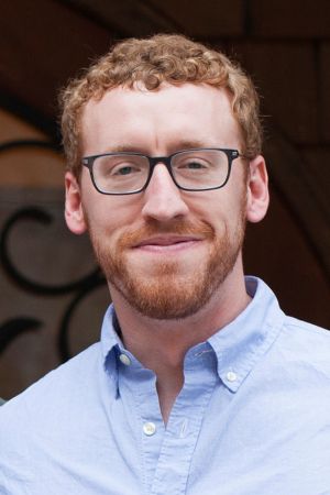
Wesley Crump
Extension Assistant Professor | Horticulture | Wasatch County
Agriculture and Natural Resources
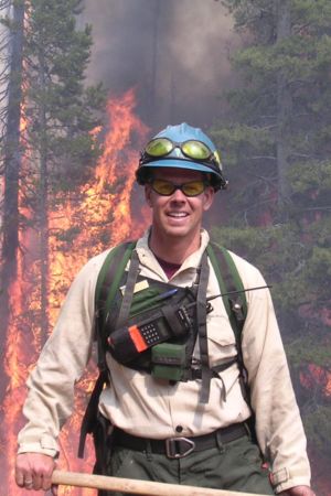
Bradley Washa
Assistant Professor of Wildland Fire Science
Wildland Resources

Lewis Kogan
Executive Director | Swaner Preserve and EcoCenter
Agriculture and Natural Resources
Scott Hotaling
Assistant Professor | Climate Resiliency Specialist
Watershed Sciences
Related Research