Upper Kane Creek
1925

1999
Description:
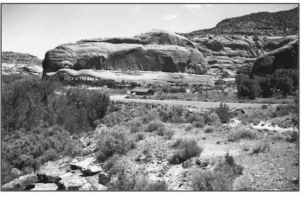
UPPER KANE CREEK 1 This photopoint is 1/4 mile southwest of the Hole-in-the-Rock at Kane Springs. The view is northeast. The foreground is public land administered by the Bureau of Land Management and the area across Highway 163 is private land. Many geomorphic, vegetation and human changes have occurred at this location in the 74 years between photographs. The vertical bank, visible at the left center of the 1925 photograph, continued to erode to the right until most of the mid-terrace was washed away to a point just short of the current road fill. New floodplains have been developed in the channel that is now somewhat stabilized. A wide variety of riparian vegetation has established across most of the channel width where little was present in 1925. This stream segment is not at a point where it can be classified as properly functioning but it is definitely trending upward. Some of the riparian species found here include Fremont cottonwood, Gooding willow, yellow willow, Russian olive, spikerush, Baltic rush, swordleaf rush, bulrush, cattail, common reed, horsetail, saltgrass, white virgin's bower, and a trace of tamarisk. Upland plants include Indian ricegrass, threeawn, cheatgrass, Mormon tea, Fremont barberry, juniper, gamble oak, singleleaf ash, fourwing saltbush, and sagebrush. The evolution of Highway 163 is obvious from these two photographs.
Photo Information:
Photograph Number: Lee No. 3088 Click here to view photograph Original: Date: 1925 (- A) Photographer: W.T. Lee Source: U.S. Geological Survey, Denver, Colorado Retake: Date: May 31, 1999 (- B) Photographer: Earl Hindley Source: San Juan County
Vegetative Community:
Riparian
Location:
San Juan: SW1/4SW1/4 Section 1 T.27S., R.22E.