White Rocks
1943
1948
1953
Description:
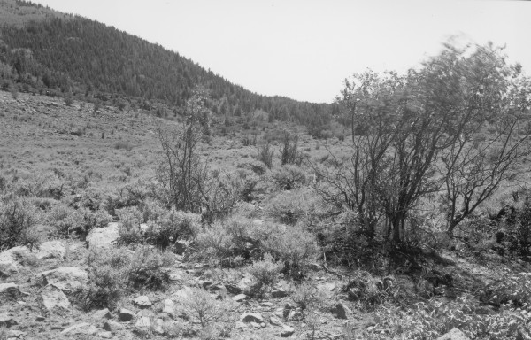
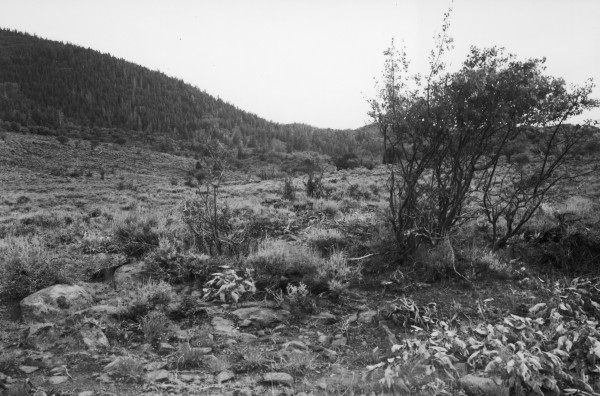
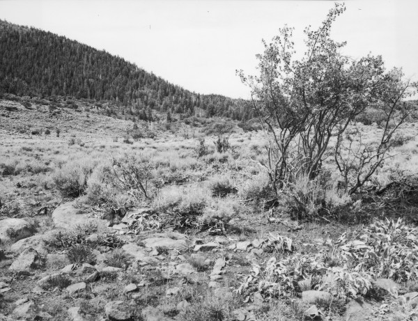
Plate 1504X. White Rocks 1943 – 1948 – 1953 – 1958 – 2007 The White Rocks Photo Plot Transect was established by the Forest Service in 1943 and reread in 1948, 1953, 1958, and 1979. The transect is 2,120 ft. in length and samples several vegetation types at the head of White Rocks Draw north of Timber Mountain in the Pine Valley Mountains. According to the 1943 narrative report, “This range is very badly abused. Oak is grazed so heavily that much of it is dead or dying. Serviceberry is highlined, and much of it is killed….Most palatable vegetation is in a poor state of vigor….too many deer and cattle graze this area.” The 1948 narrative report voiced similar concerns. “[Serviceberry] is in very bad shape. The shrubs are highlined and hedged and in very poor vigor. It is doubtful if they ever will recover from their sad state of depletion….utilization is heavy…There are doubtless too many deer for the good of the range and cattle also. Soil erosion, as in most areas of the Pine Valley allotment, is a serious problem…[with] two to three inches of soil loss…”. Conditions had not improved in 1953. “The severe sheet erosion is a real problem on this range. Present and continuing summer storms have caused heavy soil movement on both the gentle and steeper slopes. Gullies have deepened considerably. Much sediment deposited on trails and where gullies enter flats….Serviceberry, gambel oak and mountain mahogany continue as severely hedged and/or highlined as they were 10 years ago when…this transect [was established]. Cattle have been on the area only two weeks and yet proper use will soon be reached. Spots have already been used too heavy.” This despite the fact that AUM numbers had been cut by nearly 40%. Five years later, conditions were about the same. “The 1958 observation[s]…emphasize the fact that many problems still exist on [this]…range 15 years after the plots were established….the most serious situation is the continuing loss of soil…Another undesirable condition…is the expansion of sagebrush [into former grassy meadows]. [Shrubs] continue to be badly hedged and/or highlined as they were 15 years ago…” Both soil and vegetation trend were still downward. However, when Dr. Jim Bowns remeasured the transect in 1979, he reported that conditions had improved. “The active gully present in earlier records has now healed and water is again near the surface…ground cover of grasses is presently good. Snowberry and Ribes sp. are lightly grazed. There appears to be good reproduction of Cercocarpus ledifolius, but it still shows effects of high-lining and hedging. This appears to be an artifact of past grazing rather than excessive present use….This range presently appears to be in good ecological condition with an upward trend since 1958.” Plate 1504x is viewed southwest 150 ft. west of plot C-157. There is a large rock carin at C-157, while a much smaller rock carin marks the camera station. The tall shrubs nearest the camera are Utah serviceberry and the one on the right is more heavily browsed today than it was in 1943, while the other two plants are now dead due to repeated use by livestock. All Utah serviceberry and curlleaf mountain mahogany in the distance are still highlined and repeatedly browsed. In the distance aspen has declined and is in exceedingly poor ecological condition, while pinyon, juniper, spruce, white fir, ponderosa pine, and Douglas fir have all increased, as have forest fuels. Some of the older spruce were recently killed by insects and disease. Sagebrush in the foreground appears about the same. Cattle were actively grazing the area in 2007 and utilization was heavy.
Photo Information
Forest Service photographs (unnumbered) taken by Walter P. Cottam on July 22, 1943; Walter P. Cottam on July 23, 1948; Irwin H. Johnson on July 30, 1953; and Irwin H. Johnson on July 24, 1958; retake by Charles E. Kay on August 24, 2007 - - Photo No. 5834-30A.
Vegetative Community:
Mountain Brush, Sagebrush, Conifer, Juniper
Location:
South West: Section 14, Range 14 West, Township 38 S