Swains Creek
1943
1948
1953
Description:
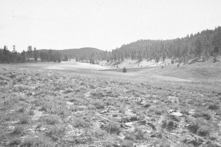
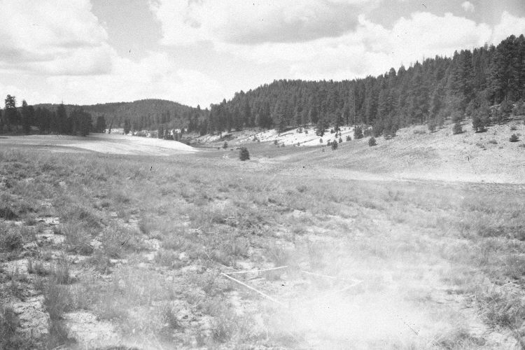
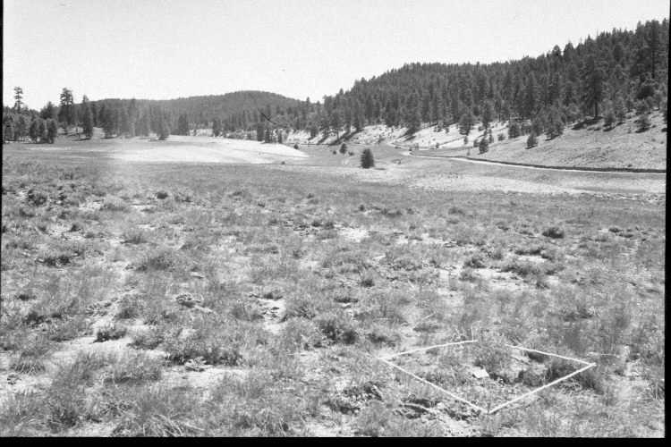
Plate 952X. Swains Creek 1943 – 1948 – 1953 – 1978 – 2005 This Photo Plot Transect was established by the Forest Service in 1943 to monitor range conditions on Swains Creek about one-half mile below Tar Kiln Hollow. According to early narrative reports, the area was very heavily grazed by livestock when the transect was established. “Much of the soil here is shallow and shows serious sheet and gully erosion over the past decades”. The wet meadow along the creek was “once extensive, but deepening [down-cutting] of the channel has drained much of it and blue spruce is rapidly invading”. In 1948, Cottam noted that “the utilization of the meadow bottom this year has been tremendous. There is at this date hardly anything but stubble left”. From 1948 to 1953, an average of 1,048 sheep used this allotment each year, consuming on average, 2,592 AUM’s every growing season. “… the range is in … poor condition and has been for a long time…The deteriorated soil condition is one of the most conspicuous features on the transect area. All plots show it and the trend is, therefore, markedly down.” This despite the fact the operator took “considerable non-use” over the proceeding six years. During the 1960’s this changed from a sheep to a cattle allotment and the Forest Service instituted rest-rotation grazing. When the transect was remeasured in 1978, Dr. Jim Bowns reported, “Species composition and soil conditions have improved since the transect was established in 1943. The area along the stream has shown the greatest improvement. Erosion is no longer a serious problem. Many of the larger gullies have healed and are now completely sodded in with desirable grasses. Overall the range is in good condition and the trend is up.” Plate 952x is viewed west-southwest from the transect’s end point at subplot C-205, back along the transect to its starting point 700 yards away. The most common grass in the 2005 retake is needle and thread, which appears to have increased, while green rabbitbrush appears to have declined. Ponderosa pine, spruce, and white fir have increased in the distance. The road up Swains Creek is on the right.
Photo Information:
U.S. Forest Service photographs (unnumbered) taken by W.P. Cottan on August 5, 1943 and August 8, 1948, by I.H. Johnson on June 25, 1953, and by Al Tait on September 30, 1978; retake by Charles E. Kay on July 29, 2005 - - Photo No. 5485-26A. Original photographs, negatives, and narrative reports held in the range files on the Cedar City Ranger District, Dixie National Forest, Cedar City, UT.
Vegetative Community:
Conifer, Dry Meadow
Location:
South West: Section 4, Range 7 West, Township 39 South; UTM of the transect end point 355300 E, 4145700 N; elevation 7,840 ft.