Second Water
1958

2004
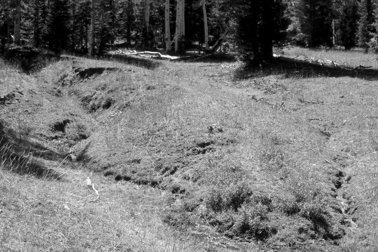
Plate 818X

Description:
Plate 818X. Second Water 1958 – 2004 The Forest Service initiated this Photo Plot Transect in 1943 to monitor range conditions at Second Water in the Pine Valley Mountains. Walter Cottam, who established the Photo Plot Transect, noted that, “An old abandoned road leading to this area, old broken-down log cabins, etc. support the historical claim that this area once supported a dairy concern. Washes 10 feet deep have gutted the meadow since that date, and meadow grasses have practically disappeared. The hillsides are badly trampled, the top soil is gone and shoestring gullies are appearing. The grasses are 80 to 85 percent utilized despite the fact that cattle have been here [for only three weeks]…there is an evident impoverishment of the vegetation [and] low vigor of palatable species. There are also many deer signs and overgrazing from both cattle and deer is everywhere evident. Drastic reduction in stock is urgent if this area is to be rehabilitated.” Cottam remeasured the transect in 1943, but found little improvement. “The old meadow with its gully system appears approximately the same. There is little palatable vegetation on it and much of it supports little vegetation [at all]. Veratrum californicum, Helenium hoopsi, and Arnica mollis are the chief plants…the hillsides over which this transect traverses show serious sheet erosion. Approximately three inches of top soil have gone and the surface is conspicuously paved. There seems to be little difference in the soil situations since 1943…there are many evidences of deer. There is little aspen reproduction and the range in general continues poor.” Irwin Johnson reread the transect five years later, but noted little improvement. “Soil and litter conditions continue to deteriorate on every plot. In some instances sheet erosion is much more pronounced, with increasing earmarks of erosion pavement, soil washed away from root crowns, undercutting on the lower side of plants and soil-rock accumulations on the uphill side. Rill marks were conspicuous on some plots because of summer storms on the area several days before the 1953 examination. Although cattle had been grazing here for only two weeks there was considerable trampling damage. Herbaceous litter is almost lacking. Litter consists essentially of pockets of aspen leaves and even these are very limited….the evidence of continuing deterioration of the soil resource on every plot permits only one conclusion for the transect area, namely, that there is still a marked downward soil trend….aspen reproduction is lacking, at least I did not notice any in the entire basin.” Johnson measured the Photo Plot Transect for the fourth time in 1958 but noted that the site was still in poor condition. “There really is not much new to add to my observation notes of July 28, 1953. They could well apply for the most part to conditions found on the area today. The sheet-eroded open slopes in the Second Water pocket are as conspicuous as they ever were. The vegetative cover is light, consisting principally of lupine, Letterman needlegrass and yellowbrush. Protection from litter is very poor-almost nil from herbaceous species. Aspen reproduction is conspicuous by its absence. Noticed a few sparse shoots that looked as though they had been hedged back year after year. Some of the snowberry is hedged. The flat below the small, wet meadow presents a deteriorated picture as does all the Second Water basin…the stream channels show fresh silt deposits and in spots the banks along the main channel below the meadow continues to cave in. Trampling by cattle keeps the raw banks in various places in an unstable condition. It hinders the natural development or perennial vegetation on bare soil….the fact that litter from palatable herbaceous species (grasses) is almost nil is proof that the use in previous seasons has been far too heavy. Even where smooth brome patches are fairly rank, litter is difficult to find.
Vegetative Community:
Aspen, Conifer, Dry Meadow
Location:
South West