Lookout Point -- Steep Creek
1943
1948
1953
Description:
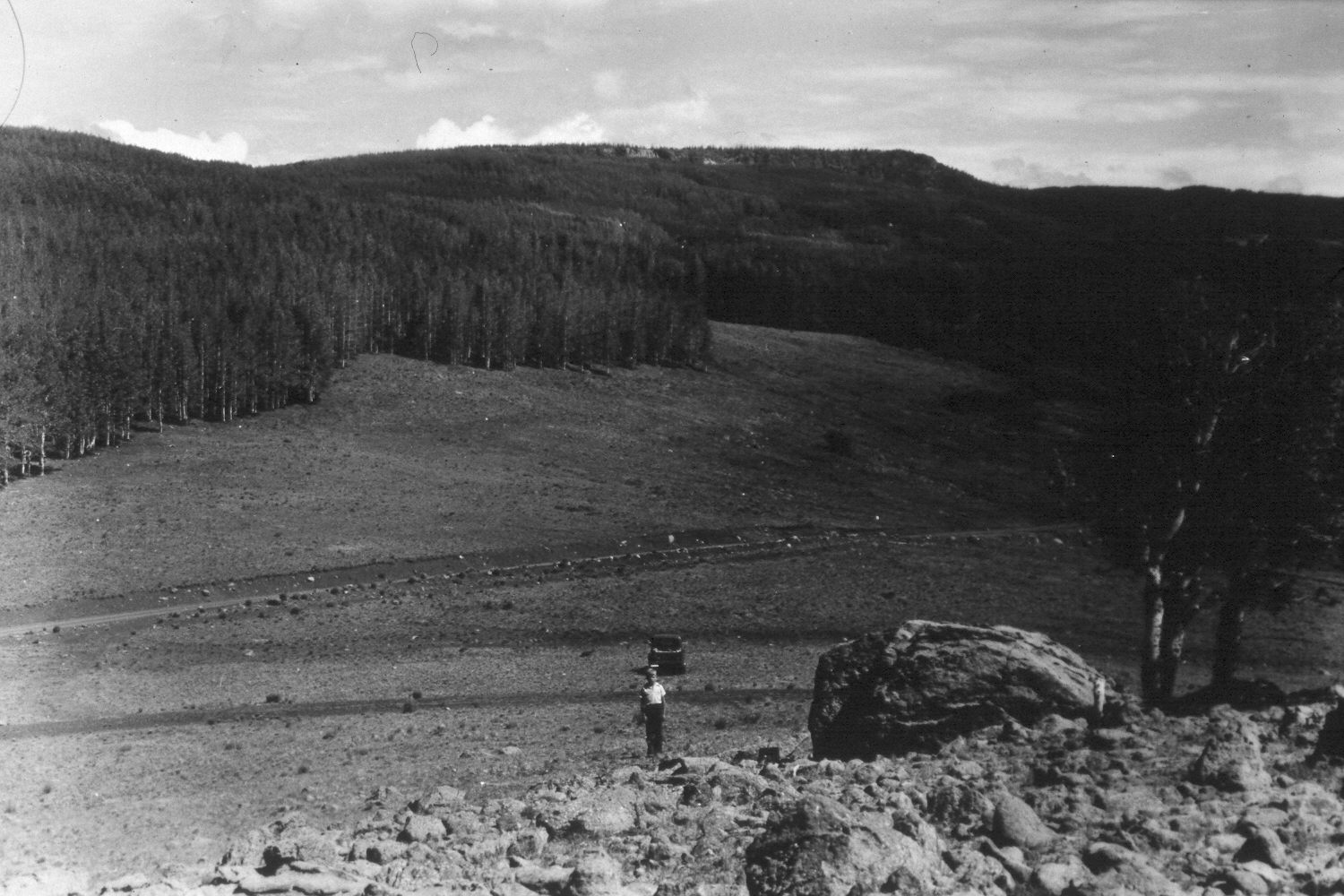
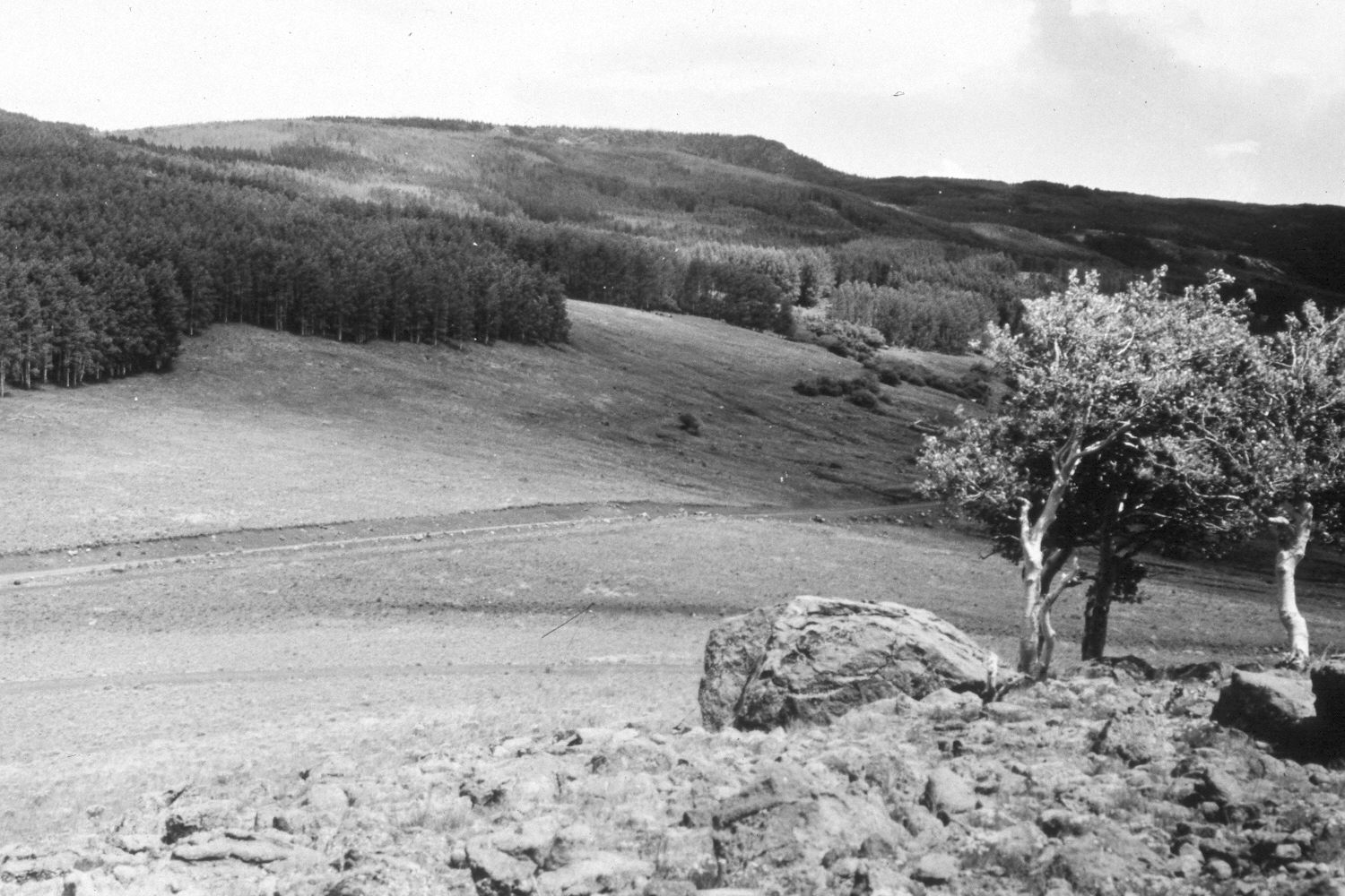
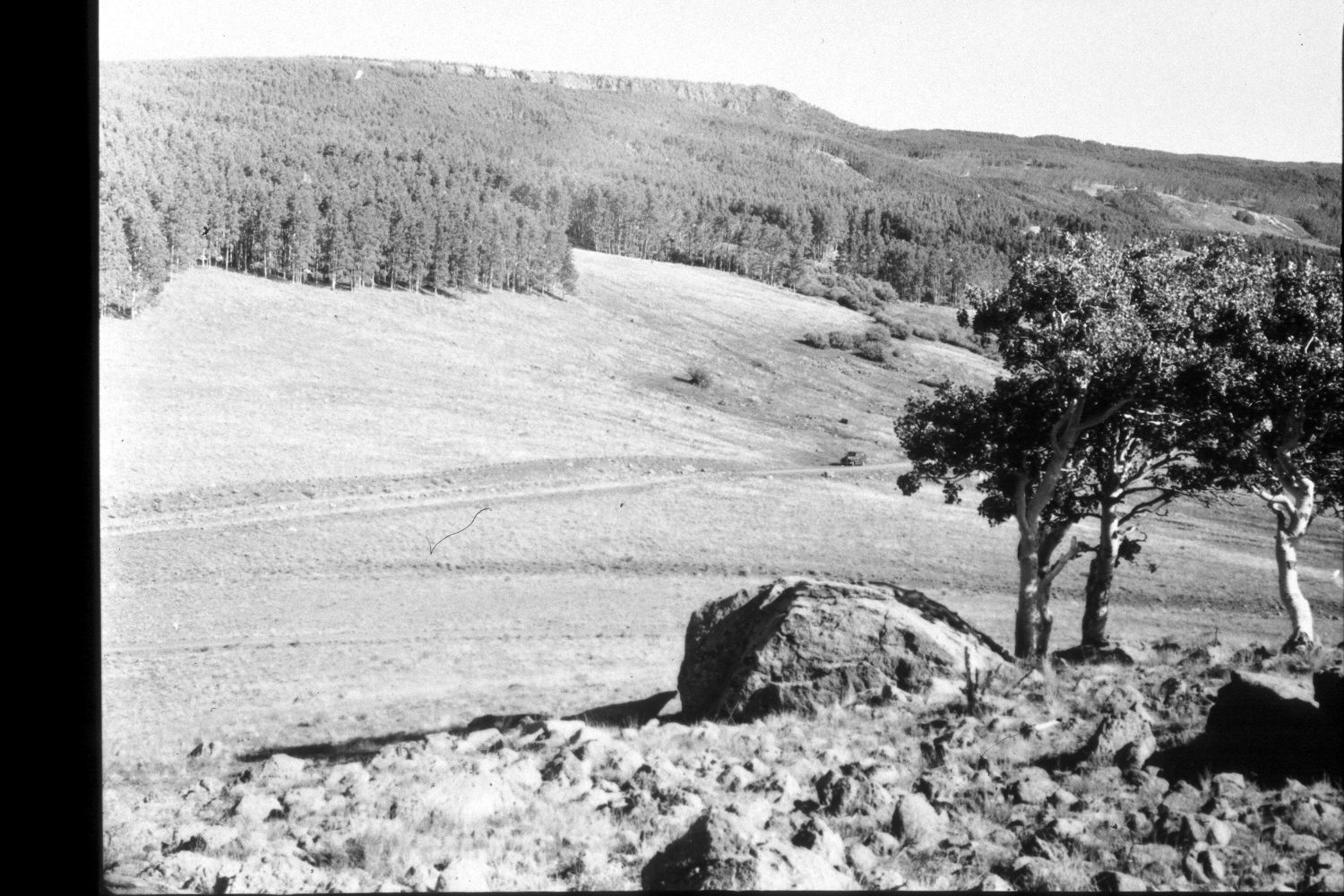
Plate 369X. Lookout Point - - Steep Creek 1943 - 1948 - 1953 - 1959 - 1973 - 2003 The Steep Creek Photo Plot Transect near Lookout Point on the southeast flank of Boulder Mountain was established in 1943 and reread in 1948, 1953, 1959, 1973, and 1979. The transect is 1990 feet in length and consists of ten plots. The transect samples both grassland and aspen communities. When this Photo Plot Transect was established, the area was very heavily grazed by domestic sheep, and range conditions were described as poor. Dr. Walter Cottam, who remeasured the transect in 1948, noted some improvement in the grasslands, but concluded that “aspen reproduction [was] in much worse shape than it was in 1943. Very few aspen leaves remain on the old [suckers], and about 50 percent…are dead. A few scattered [snowberry plants] are also badly hedged and dying”. In 1953, the vegetation trend was described as improved, but I.H. Johnson found that “not far from the transect…there is active cutting in the gully channels, grass clumps continue to be undermined by sheet erosion, and there are many raw spots that showed much trampling…from sheep…” By 1959, though, conditions had deteriorated. “Positive elements pointing to betterment between 1953 and 1959 are practically nil…the trend for vegetation is downward and to a marked degree.” After the transect was measured for the last time in 1979, Dr. Jim Bowns, range ecologist at Southern Utah University, wrote that “comparing this area now with the original photos makes it apparent that the trend is up and condition is good.” Dr. Bowns also reported that “aspen reproduction is very dense in the outer edges of the stands. This is now a common phenomenon on the east side of Boulder Mountain” (unpublished reports in the range files on the Teasdale Ranger District, Dixie National Forest, Teasdale, UT). Plate 369x is viewed northeast from the Photo Plot Transect starting point near the top of Lookout Point. The person and vehicle in the 1943 image are on the transect centerline. Utah Highway 12 bisects the transect and that road has now been widened and paved. There was no aspen regeneration in either the 1943, 1948, 1953, or 1959 images, but aspen regeneration is visible in the 1973 image. Many aspen stands on Boulder Mountain regenerated during the early 1970s, when mule deer populations declined (Kay and Bartos 2000). As elk populations have increased and mule deer numbers recovered, however, those animals have highlined all the new aspen saplings - - this is why the trees in the foreground lack their lower branches - - and repeatedly browsed new aspen suckers, preventing additional regeneration. Willows in the distance appear unchanged. Grass cover has improved despite the extended drought and there was no evidence of recent soil erosion - - all indicators of an upward trend. Snowberry has increased, especially on the open slope about the road. Needle and thread is the most visible grass. The area was actively being grazed by cattle in 2003.
Photo Information:
U.S. Forest Service photographs (unnumbered) taken by Ray J. Davis on July 20, 1943; Walter P. Cottam on July 16, 1948; I.H. Johnson on September 13, 1953; I.H. Johnson on July 29, 1959; and by an unknown cameraman in 1973; retake by Charles E. Kay on August 28, 2003 - - Photo No. 5270-3. Original photographs, negatives, and narrative reports held in the range files on the Teasdale Ranger District, Dixie National Forest, Teasdale, UT
Vegetative Community:
Aspen, Mountain Brush, Dry Meadow
Location:
South West: Section 21, Range 5 East, Township 32 South; UTM of transect starting point 468700 E, 4207200 N; elevation 9,500 ft.