Coyote Hollow
1943

1948
1953
Description:
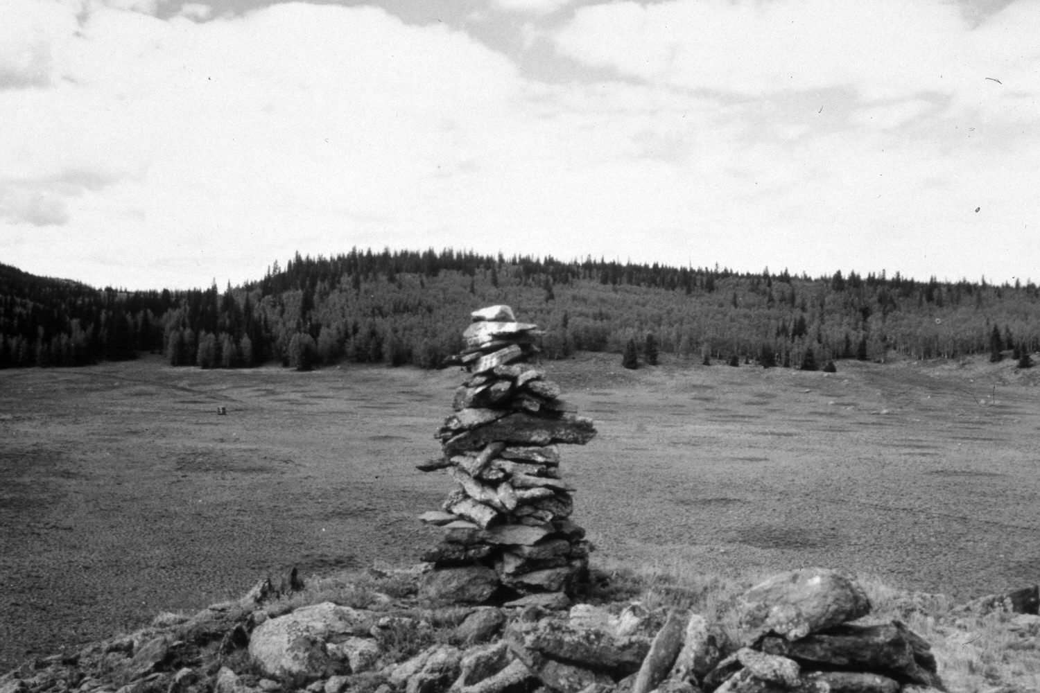
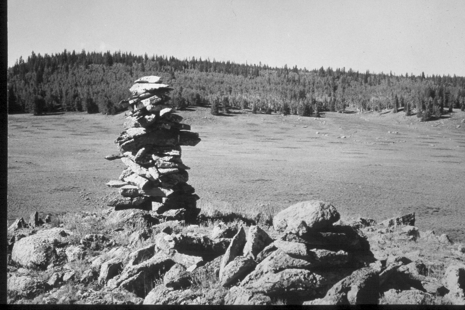
Plate 330X. Coyote Hollow 1943 - 1948 - 1953 - 2003 The Coyote Hollow Photo Plot Transect on the Aquarius Plateau was established in 1943 and reread in 1948, 1953, and 1979. The transect is 2400 feet in length and is located approximately 400 yards below Coyote Hollow Reservoir. Five of the eight plots on this transect sample a silver sage meadow, while the remaining three plots sample the aspen-spruce type. When this transect was established, the range was in poor condition and soil erosion was widespread. “Between 1943 and 1948 sheep use was eliminated” on this allotment. Nevertheless, in 1953 I.H. Johsnon noted that “the evidence of deterioration of the forage resource over shadows the minor indication of some improvement…in weighing all the factors, the evidence points most strongly to the conclusion that the vegetation trend is downward…[In addition] there are no indications that soil loss is being stopped in any noticeable degree.” By 1979, however, conditions had improved for according to Dr. Jim Bowns, range ecologist at Southern Utah University, “there is presently little indication of soil movement. Condition is difficult to assess due to the low productive potential. I would judge this range to be in fair condition. Trend has been upward since the transect was established.” Dr. Bowns added that the pedestaled grass plants were the result of “frost hummocking rather than strictly soil movement due to overgrazing” (unpublished reports in the range files on the Escalante Ranger District, Dixie National Forest, Escalante, UT). Plate 330x is viewed southwest from the transect starting point above Coyote Hollow. The truck in the 1943 image is on the transect centerline. The entire area is dotted with mima mounds - - slightly-elevated circular landforms created by pocket gophers over hundreds or thousands of years. Sheep fescue (Festuca ovina) is the most common grass while the most common shrub is silver sage, which is especially thick on top of mima mounds where soils are deeper. Despite the severe drought that has gripped southern Utah for several years, range conditions appear to have improved and there is no evidence of recent soil erosion. In the distance, conifers have increased, while aspen has declined. All aspen suckers showed evidence of repeated browsing. Silver sage appears to have declined. The area was actively being grazed by cattle in 2003. Elk use was also evident.
Photo Information:
U.S. Forest Service photographs (unnumbered) taken by Ray J. Davis on June 22, 1943; Walter P. Cottam on June 24, 1948; and I.H. Johnson on August 28, 1953; retake by Charles E. Kay on August 25, 2003 - - Photo No. 5248-6A. Original photographs, negatives, and narrative reports held in the range files on the Escalante Ranger District, Dixie National Forest, Escalante, UT.
Vegetative Community:
Sagebrush, Conifer, Aspen
Location:
South West: Section 21, Range 1 East, Township 32 South; UTM of transect starting point 430450 E, 4206500 N; elevation 9,480 ft.