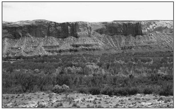
San Juan River West Of Bluff, Utah
1925

1999
Description:
SAN JUAN RIVER WEST OF BLUFF, UT This south-southeastern view of the San Juan River is about 1.8 miles west of where Highway 163 crosses Cottonwood Wash at Bluff. The photopoint is on BLM administered land looking toward private land on the San Juan floodplain. BLM land is also found near the current active channel. Soils immediately south and below the uplands in the lower portion of the 1999 image are Gilco silty clay loams. They extend about .2 mile into the floodplain toward the river. Soils from there to the river are Trail fine sandy loams. Gilco silty clay loam soils occupy stream terraces and are typically very deep with potential rooting depths of more than 60 inches. They also have moderate or moderately high available water capacities. Trail fine sandy loam soils occupy floodplains. They are also very deep with potential rooting depths of more than 60 inches. Drainage varies from well drained to poorly drained. Less well drained Trail fine sandy loams are more capable of supporting riparian plants such as sedge and rush species. Seventy years of records taken at Bluff, Utah just two miles east of this location show an average annual precipitation rate of 6.8 inches. Striking differences in terrace, floodplain and vegetation characteristics are visible between the 1925 and 1999 photographs. The entire terrace and floodplain system has developed since 1925. The once wide (.75 mile), shallow and braided active channel has narrowed to about 150 to 200 feet near the far canyon wall. Portions of the floodplain have been used for crops in the past. Expansion of the riparian zone indicates that the banks and floodplain are collecting and holding water resources much longer than was previously possible. Although much of the new vegetation is exotic such as tamarisk and Russian olive, many native riparian plants have established including Fremont cottonwood, Gooding willow, coyote willow, rush and sedge species. Many cottonwood seedlings and poles indicate that cottonwood is an increasing specie here.
Photo Information:
Photograph Number: Lee No. 3172 Click here to view photograph Original: Date: 1925 (- A) Photographer: W.T. Lee Source: U.S. Geological Survey, Denver, Colorado Retake: Date: June 1, 1999 (- B) Photographer: Earl Hindley Source: San Juan County
Vegetative Community:
Riparian
Location:
San Juan: NW1/4NE1/4 Section 34 T.40S., R.21E.