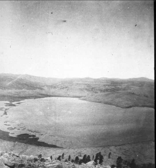
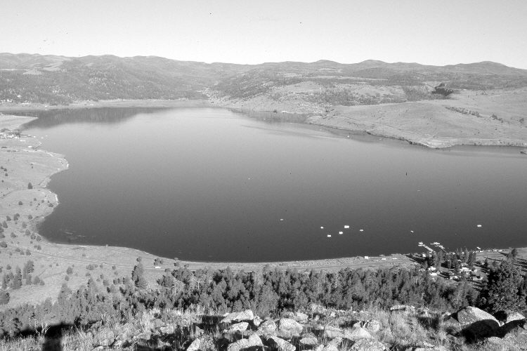
Panguitch Lake
1872
2005
Description:
Plate 1041X. Panguitch Lake 1872 – 2005 Viewed west to Panguitch Lake from Cooper Knoll on the Dixie National Forest. In 1872, conifers below the photopoint were all older, widely-spaced ponderosa pine with little conifer regeneration due to a high frequency of low intensity fires. With more than 130 years of fire suppression, however, the pine forest has thickened-up considerably and has now been invaded by Douglas-fir, a species more sensitive to fire - - see Plates 1014x and 1017x. Conifers have also increased dramatically on the mountains west of the lake. There is now a dam on the lake’s outlet that has raised the water level and flooded out the islands and shoreline vegetation seen in the initial image - - see Plate 1016x. Utah Highway 143 can be seen below the photopoint, and other roads and developments are visible as well. Although haze makes it difficult to see in the original, aspen has declined, while sagebrush has increased. Lakeview Lodge is on the lower right, while Panguitch Lake Resort is on the far left-center. Blue Spring Creek enters Panguitch Lake from the southwest (left), Clear Creek from the west (photo left-center), and Ipson Creek from the north (right).
Photo Information:
Original photo taken by John Hillers (No. 48) as part of the Powell Survey in 1872; retake by Charles E. Kay on August 6, 2005 - - Photo Nos. 5521-10A. Original photograph (57-PL-48) held by the National Archives, Washington D.C.
Vegetative Community:
Conifer, Aspen, Sagebrush
Location:
South West: Section 3, Range 7 West, Township 36 South; UTM 357400 E, 4174600 N; elevation 9,000 ft - - lake elevation 8,212 ft.