Panguitch Lake
1872
1999
Description:
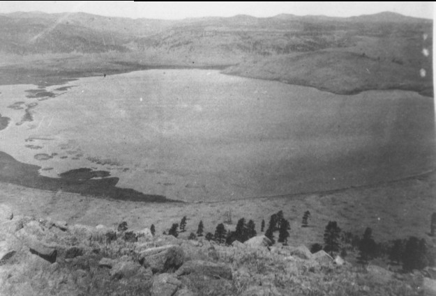
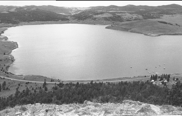
Plate 71. PANGUITCH LAKE: 1872 - 1999 In 1872 the conifers below the photo point were all large, widely spaced ponderosa pine (Pinus ponderosa) with little regeneration due to a high frequency of low intensity fires. With over 100 years of fire suppression, the pine forest in the 1999 photo is considerably more dense and has been invaded by Douglas-fir (Pseudotssuga douglasii), a species more easily damaged by fire. Conifers are also more abundant in 1999 on the mountains behind the lake. A dam on the lake’s outlet has raised the water level in the 1999 photo and flooded out the islands and shoreline riparian vegetation apparent in the 1872 photo. Aspen (Populus tremuloides) appears to have declined and sagebrush (Artemisia tridentata) increased over the intervening years. Utah Highway 143 and other roads and developments are visible in the 1999 photo.
Photo Information:
1872 photo taken by John Hiller [#48] as part of the 1872 Powell survey; 1999 photo is Kay #4456-33, taken on July 27. Hiller’s photo [#57-PL-48] held by the National Archives, Washington, D.C.
Vegetative Community:
Conifer, Riparian, Aspen, Sagebrush
Location:
South Central: T36S, R7W, Sect. 3, UTM 4174600 N, 357400 E; elevation 9,000 ft., viewed west.