Mountain Meadows
1909
2004
Description:
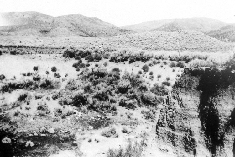
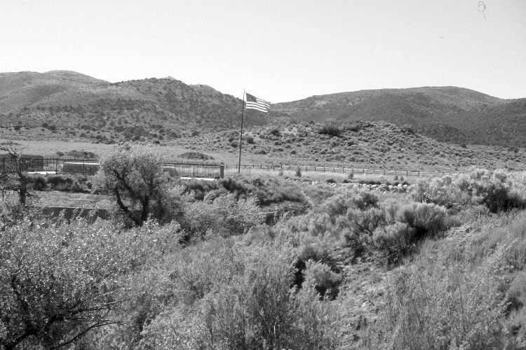
Plate 684X. Mountain Meadows 1909 – 2004 During the early 1800’s, Mountain Meadows was a favorite resting place on the trail to California because of its cold, clear water and abundant forage. In 1851, Parley P. Pratt, an apostle of the Mormon church, noted that “this little mountain paradise was, by the present road, three hundred and eleven miles from …Salt Lake City, and was altogether the most beautiful place in all the route. One thousand or fifteen hundred acres of bottom, or meadow lands were spread out before us like a green carpet richly clothed with a variety of grasses, and possessing a soil both black [and] rich…it was everywhere moistened with springs…the surrounding hills were abrupt, but rounded off…and everywhere richly clothed with the choicest kind of bunch grass and bordered in their higher eminences with cedar [juniper] and nut pine [pinyon] sufficient for fuel” (Cottam 1929: 361-362). A lovely place indeed that unfortunately was seared into American history on September 7-11, 1857 as the site of the Mountain Meadows Massacre. According to the plaque that was erected in 1932 “In this vicinity…occurred one of the most lamentable tragedies in the annals of the West. A company of about 140 Arkansas and Missouri emigrants…en route to California was attacked by white men and Indians. All but 17, being small children, were killed. John D. Lee, who confessed participation as leader [of the attackers] was legally executed here [on] March 23, 1877” (Cottan and Stewart 1940). For additional details of the incident at Mountain Meadows see Brooks (1991). In 1862, the meadow was permanently settled by Europeans who brought in large herds of cattle and sheep, which proceeded to overgraze the area. “While waiting execution at the scene [in 1877 for his part in the Mountain Meadow Massacre], John D. Lee told the officer in charge that the entire landscape had, during the twenty years since the crime, undergone such great changes…as to make impossible the accurate designation of particular landmarks…” (Cottam and Stewart 1940). Then in 1884 heavy spring rains fell on the denuded range and generated an abnormally large flood that ripped open ugly washes in one protracted period of erosion. “Since that time the main wash has deepened, and side gullies have fingered out to nearly all parts of the meadow. With the meadow drained and with [livestock] herds on the increase, grassland rapidly gave way to desert shrub” (Cottam and Stewart 1940). That is to say, since European settlement, there has been a complete transformation of valley vegetation. Cottam and Stewart (1940) also reported that pinyon and juniper had begun to invade the surrounding hillsides. Plate 684x is viewed northwest to the Mountain Meadows Memorial. The original rock structure was recently replaced with a more substantial monument by the Mormon Church. Woody riparian vegetation has increased along Magotsu Creek in the foreground. The cutbanks are more vegetated today than in the past. Pinyon, juniper, and mountain brush have increased on the distant hillsides.
Photo Information:
Original photograph taken by Josiah Gibbs in 1909; retake by Darrell McMahon on June 3, 2004 - - Photo No. DM-18-24. Original photograph (10853) held by the Utah Historical Society, Salt Lake City, UT.
Vegetative Community:
Dry Meadow, Pinyon, Juniper, Sagebrush
Location:
South West: Section 22, Range 16 West, Township 38 South; UTM 266290 E, 4150864 N; elevation 5,674 ft.