Merchant Creek
1936
1999
Description:
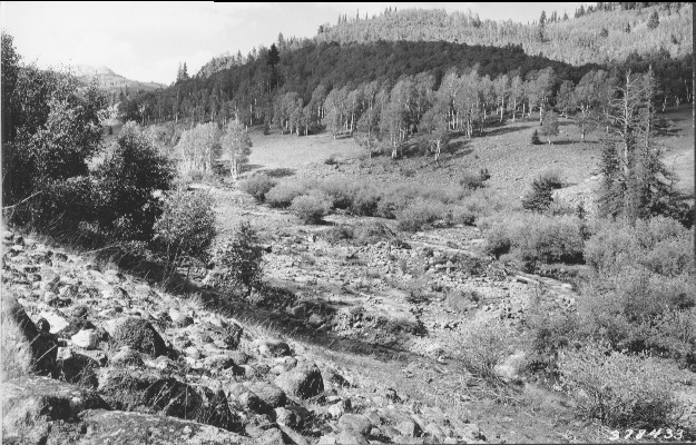
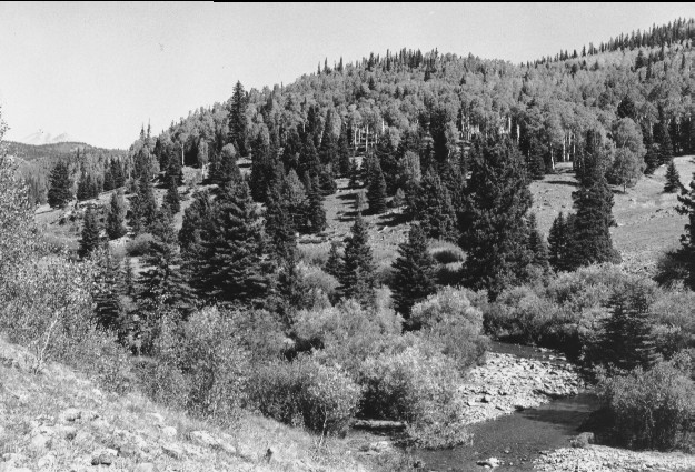
Plate 155 MERCHANT CREEK: 1936 - 1999 Shelly Baldy Peak (elev. 11,321 ft.) is in the distance. The 1936 photo was taken to document the amount of erosion and stream instability. The 1999 photo shows how willow (Salix spp.) have increased and reduced the bank erosion. Conifers, primarily spruce (Picea sp.), are also more abundant in 1999 with a corresponding decline in aspen (Populus tremuloides). The aspen stands across the creek have been invaded by conifers and none of these aspen have regenerated. The 1936 photo point could not be used in 1999 because of the growth of the aspen clone on this side of the creek (left center); this is the only aspen that has regenerated in the immediate area. A number of summer homes across the creek are hidden by conifers.
Photo Information:
1936 photo #378433 taken in July by the U.S. Forest Service; 1999 photo taken by Kay[#4504-7 on Sept. 8. Forest Service photo held by the Utah Historical Society, Reed W. Bailey Collection, Salt Lake City, UT
Vegetative Community:
Aspen, Conifer, Riparian
Location:
South Central: Tushar Mountains, Fishlake National Forest, Beaver Ranger District; T29S, R5W, Sect. 9, UTM 4240550 N, 374900 E; elevation 8,580 ft., viewed to north.