Mail Station Draw
1927
1998
Description:
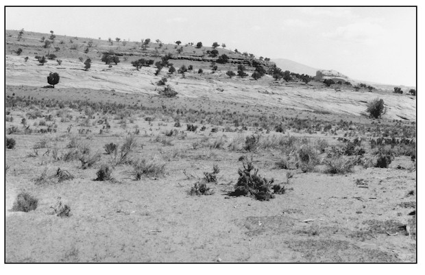
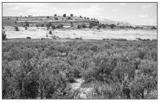
MAIL STATION DRAW This site is approximately 1 mile up Mail Station Draw from where it joins Hatch Wash. The view is northeast across public land administered by the Bureau of Land Management. This deep valley bottom soil is classified as Redbank fine sandy loam. It is generally a reddish yellow and often exceeds depths of 60 inches. Permeability is moderately rapid with medium water supplying capacity. This particular site tends to be somewhat sodic. Average annual precipitation at this location ranges from 10 to 12 inches. It is obvious that this mixed sagebrush/greasewood community has recovered health and vigor since 1927. The result is a much improved protective ground cover. Interspaces do contain exotic annual species such as cheatgrass, Russian thistle, and storksbill, but there are also good populations of native species as well. Native grasses include curlygrass, squirreltail and blue grama. Some other species present include pricklypear cactus, snakeweed, rabbitbrush, with juniper and skunkbush near the far slickrock outcrop. Mail Station Draw has a single ephemeral uncut channel.
Photo Information:
Photograph Number: Goldman No. 331
Original: Date: May 15, 1927 (- A) Photographer: M.I. Goldman Source: U.S. Geological Survey, Denver, Colorado Retake: Date: May 10, 1999 (- B) Photographer: Earl Hindley Source: San Juan CountyVegetative Community:
Sagebrush
Location:
San Juan: SW1/4SW1/4 Section 3 T.30S., R.23E.