Using Thermal Camera Drones in Beef Cattle Roundup
Introduction

Small unmanned aircraft systems (sUAS or simply UAS), also known as drones, are being heavily implemented in multiple areas of agriculture, taking advantage of a wide range of application possibilities. A few examples include monitoring crop life, herding and supervising cattle movement, and spraying weeds and crops. Livestock producers are now using drones to check fence lines, monitor calving, and conduct property water surveys (Bolanos, 2022). Producers have found that using drones helps them save time and effort by expediting tasks (Schelfhorst, 2022).
Here in the Intermountain West, livestock are typically summered in mountain ranges nearby and collected each autumn to access lower pastures during the harsh winter months and ease closer monitoring during calving. Calving is conducted from late January to February in the winter range closer to home, where the cow and calf can be closely monitored with less snow. Grazing during the summer in the high range reduces grasses and fire hazards and allows the low land to produce feed for cattle during the winter.
Using mountain ranges and pastures comes with its own set of challenges. Spring turnout of cattle on mountain ranges requires less time and effort than gathering cattle at the end of the fall season. During the fall, it’s a larger process to move the cattle back to holding pens and trailers, as the cattle have dispersed across the mountain and need to be re-gathered. Cows like to explore their environment, and they can get lost in the process; coupled with the harsh landscape (Photo 1), it becomes more difficult to find and gather the entire herd (Bailey et al., 2021). This roundup may take a few trips up and down the mountains, riding the range on horses, or using all-terrain vehicles (ATVs).
Integrating drones to aid in cattle recovery and movement is an effective way to overcome some of these cattle-specific challenges. Cattle can be quickly located by employing a drone that easily moves across the mountainside or within ravines. This allows the livestock producer to conveniently identify areas to focus horseback riders’ efforts to gather cattle. Using drones not only saves time and money but also reduces the risk of injury to the horse and rider in the rough terrain of western mountain ranges.
FAA Certificated UAS Training
To fly drones other than recreationally, the operator needs a Federal Aviation Administration (FAA) Part 107 Remote Pilot Certificate when receiving compensation commercially using a drone (FAA, 2023). Rounding up cattle is a prime example of how someone may use a drone and not realize it falls under the Part 107 certification rules. In this case, if the producer or ranch employee wants to fly a drone to find cattle, they would have to earn this certificate to be federally legal. This certificate is earned by taking a national test and then completing recurring training every 24 calendar months. The original certificate has a one-time fee, but all recurrent training is free. For more information on how to obtain your FAA Part 107 Remote Pilot Certificate, please see the USU Extension fact sheet “Introduction to Drones” or contact the Aggie Drone Academy through USU Extension.
Research – Project Overview
Utah State University (USU) Extension and the Aggie Drone Academy conducted several different projects at two locations using drones to find lost cattle or other animals via a thermal sensor on the drone. The first location was in October, the second location in December.
First Location Test
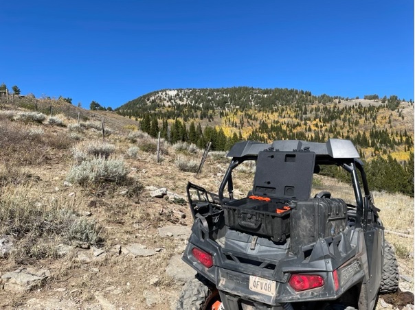
At the first location, a team with two thermal drones joined cattle producers to locate cattle and scout out some of the local summer mountain ranges. This drone team was equipped with two Autel EVO II Dual 640T V3 drones, a side-by-side ATV (Photo 2), and handheld radios. The livestock producers had approximately three teams of horseback riders. The drone team and one producer reached the location at 8:00 a.m. and deployed two thermal camera drones to different search areas. The drone team would deploy one drone with one visual observer, keeping the operation compliant with FAA Part 107 regulations.
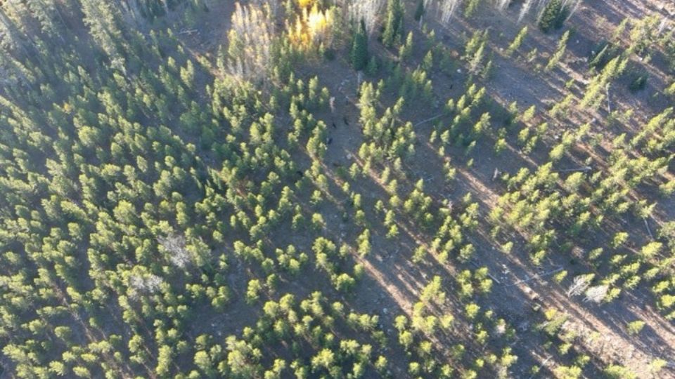
Two small groups of cattle were located, one in a grove of pine trees (Photo 3) and a second in an aspen grove (Photo 4). The drone team then moved farther up the mountain, waiting for horseback riders to gather the first groups of cattle.


Photos: Eric Galloway
The livestock producer knew the landscape from experience and knew several extremely difficult locations for horseback riders to access. The team determined to check for cattle in those hard-to-access areas using the drone. These areas were quickly checked using the thermal drones (approximately 15 minutes of flight time) and found to have no cattle.
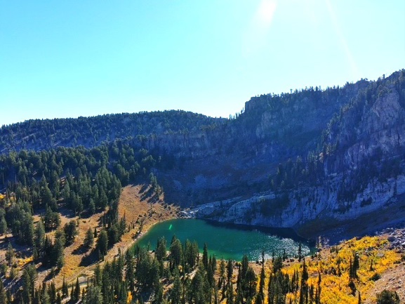
Photo: Eric Galloway
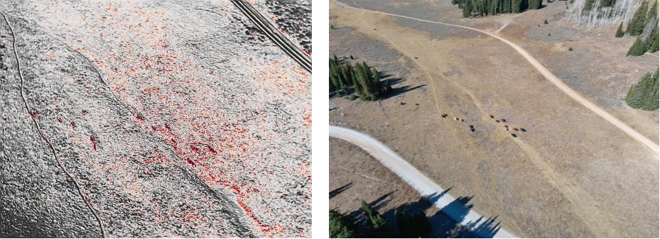
A drone flew over an approximately 2-acre area of dense brush and timber on the north side of a small ridge in less than 10 minutes, and no cattle were found. Unknowingly, horseback riders also searched the same area and didn’t find any cattle confirming the drone search results. When asked how long it took to search that same area, they indicated roughly 65–75 minutes. The drone only required 15% of the time to search the same area (Photo 5).
Second Location Test
The second location used in testing the drone implementation had been impacted by fire and floods, which made the normal routes back to lower pastures unpassable. The team rode on horseback for a mile to reach the search area. The drone team was deployed with an Autel Evo II Dual 640T V3 drone to search for 40 cow-calf pairs. The highest altitude above ground level was under 400 feet, per FAA regulations; however, about 1,800 feet above the take-off point of the drone, all the while following terrain to establish the regulated height. The total area covered during this flight mission alone was approximately 1,500 acres (counting vertical and horizontal coverage).
In less than 30 minutes, and covering an area of about 600 acres, a single cow with a calf was found. The team then conducted a search around the nearby mountains to eliminate other possible areas for other cattle (Photo 6).

Photo: Shalyn Drake
The livestock producer knew the landscape and the different locations where the cows would normally gather. The rough terrain and impassable areas due to recent floods made it almost impossible to approach the areas, even on horseback. By using the drone and its thermal capability, the team was able to search these areas with just a short walk of about 100 yards.
Limitations
Drone Air Time
The first obstacle common in all drone usage areas is how long the drone can stay in the air. Most batteries would last about 25 minutes based on altitude and wind conditions on a clear, calm day. The number of maneuvers also influences the amount of battery used per flight. The first team brought 10 batteries with them, which allowed approximately 4 hours of flight time. This particular day took between 7–8 hours to gather up the cattle. The drones weren’t used 100% of the time in the air, but having a power bank or the ability to charge batteries on a speed charger would be a great addition to a similar operation. In addition, the teams found that winds coming up from the valley, which is very common in the fall, caused the drones to use up more power by fighting the higher wind conditions. This, in turn, reduced flight time. In December, the battery life was decreased to about 15 minutes due to temperatures lower than 30 °F. Fortunately, the cold area covered also meant that the thermal readings helped find animals’ heat more quickly. However, the cold also meant that the animals didn’t move as much, which made it harder to identify them because movement is one technique for finding identifiable heat signatures of lost animals.
Ambient Temperatures Affecting Thermal Imaging
Other limitations were identified with the thermal imaging as ambient environmental temperatures increased to exceed or match the thermal image of the cattle. As the daytime temperature increased into the low 90s (Fahrenheit), imaging quality decreased. Around 11:00 a.m., it became difficult to tell the difference between a rock that was 98 °F and a cow that was 101 °F (Photo 7).
However, by using the thermal camera’s forward-looking infrared (FLIR) feature, real-time temperature readings confirmed the slight difference in temperatures. Even though it was easier and more effective to see cattle in the cooler morning, finding stationary cows near large rocks or outcroppings required more effort. The most effective thermal setting after the temperature rises is called gradient fire. Movement detection was the key to finding animals. The teams also found that evergreen trees gave off heat signatures in both locations, making it difficult to confirm cattle sightings.
Communication
The last limitation was a communication problem between the livestock producer and the drone team. Even though the producer was accompanying the drone team, and they spoke directly, there was still lacking knowledge of drone capabilities and terms used by drone pilots, which caused a slight delay in finding the cattle.
A proven method to reduce communication problems is to develop a basic plan that outlines the overall objective and divides up responsibilities between all involved in the operation. By using a map of the area and marking the “hot spots” before launch, the drone team wouldn’t have to wonder where to fly next. Even though there was communication with handheld radios, a set or expected plan would have been helpful to coordinate the efforts with the lead cattle producer, the producer’s team, and the drone team. Using known and practiced search and rescue patterns with drones would be an effective use of resources in locating individual missing livestock at the end of the season.
Search and Rescue Methods

(Civil Air Patrol, 2019)
Once “hot spot” areas are determined, the drone team can plan for search and rescue flight patterns used by public services, the Civil Air Patrol (Civil Air Patrol, 2019), and more with drones. The first most-used flight pattern for large areas is a parallel search pattern with the camera gimbal set at nadir (straight-down, -90°) and flying at very low speeds (Photo 8).
The team would need at least one pilot, one dual controller to watch the screen, and one visual observer. Another common large-area search pattern is a sector search, which uses similar gimbal and speed settings but begins each sector (triangle) at the same spot and moves outward from there (Photo 9).


Based on the livestock producer’s knowledge of the area, a potentially better option would be an expanding square search (Photo 10). In that situation, you begin in a familiar area or even an area where you have already found wandering cattle. From there, you make progressively larger squares outward to cover the surrounding area. In this type of pattern, a gimbal setting closer to -70° would be appropriate in canvasing the area, and speed could also potentially increase slightly from the previous patterns.
The final pattern teams could use would work best when ready to gather and herd with a foot team. A constant orbit around the area allows those traveling on foot to “eyeball” the location via the drone. It’s a way to communicate where to go.
Manual flight skills are essential in each of these situations, as well as a full team to keep the drone in visual line of sight and to utilize visual observers, both components per FAA Part 107 operations and limitations.

Conclusion
Using drones with thermal sensors can be an effective tool in finding and collecting livestock from summer mountain ranges in the West. Drones can complete searches in much less time than required on horseback in demonstrated areas (Photo 11). Using drones reduces the workload of the rider and horse, saving time and energy and reducing the risk of injury. With proper training and certification, livestock producers can use drones for locating cattle and many other cost-cutting operations. The return on investment for buying a thermal drone can be validated by finding missing cattle that would otherwise be lost, recovering working hours of ranch hands searching day after day, and any additional costs incurred.
Suggested Items and Operating Conditions
- Thermal drone.
- FAA Part 107 Remote Pilot Certificate.
- Landing pad.
- Handheld radios.
- Battery bank.
- Speed charger.
- Side-by-side ATV.
- Map of area.
- Cool ambient temperature.
Contact Information Aggie Drone Academy
Shawn “BW” Barstow, Director
USU Extension Assistant Professor,
Aviation Technology, UAS
Phone: 435-613-5253
Email: shawn.barstow@usu.edu
Justin Clawson, Cache County Manager
USU Extension Assistant Professor,
Agriculture and Natural Resources
Phone: 435-752-6263
Email: justin.clawson@usu.edu
Shalyn Drake, Manager
USU College of Agriculture and Applied Sciences
Lecturer, Aviation Technology
Phone: 435-613-5506
Email: shalyn.drake@usu.edu
Photo Credit
Justin Clawson provided all images unless otherwise noted.
Funding Acknowledgment
This fact sheet was supported by the High Plains Intermountain Center for Agricultural Health and Safety CDC/NIOSH Grant No. U54OH008085. Its content is solely the responsibility of the authors and does not necessarily represent the official views of CDC/NIOSH, Utah State University Extension, or the Utah Agricultural Experiment Station.
Sources
- Bailey, D., Trotter, M., Tobin, C., & Thomas, M. Opportunities to Apply Precision Livestock Management on Rangelands. https://www.frontiersin.org/journals/sustainable-food-systems/articles/10.3389/fsufs.2021.611915/full
- Bolanos, J. (2022). Using drones in agriculture and natural resource management. Pennsylvania State Extension. https://extension.psu.edu/using-drones-in-agriculture-and-natural-resource-management
- Civil Air Patrol. (2019). Mission sUAS task guide. U.S. Air Force Auxiliary. https://www.gocivilairpatrol.com/media/cms/sUAS_MP_T_TaskGuide_V3_FC65BA7DA9D3B.pdf
- Federal Aviation Administration. (2023, August 8). Certificated remote pilots including commercial operators. FAA.gov. https://www.faa.gov/uas/commercial_operators
- Schelfhorst, E. (2022). Drones for monitoring sheep welfare at lambing. Boort BestWool/BestLamb, Agriculture Victoria. https://agriculture.vic.gov.au/__data/assets/pdf_file/0007/857347/GroupProfile-BWBL-Boort-April-2022.pdf
- Thomas, H. (2022). Drones: The 21st century ranch hand. Progressive Cattle. https://www.agproud.com/articles/55192-drones-the-21st-century-ranch-hand
- Vincent-Lamert, C., Pretorius, A., & Tonder, B. (2023). Use of unmanned aerial vehicles in wilderness search and rescue operations: A scoping review. Wilderness & Environmental Medicine, 34(4), 580–588. https://www.sciencedirect.com/science/article/pii/S1080603223001928

March 2025
Utah State University Extension
Peer-reviewed fact sheet
Authors
Justin Clawson, Eric Galloway, Shalyn Drake, Shawn Barstow, Ross Israelsen, and Michael Pate

Justin Clawson
Extension Assistant Professor | Agriculture & Natural Resources | Cache County
Agriculture and Natural Resources

Shawn "BW" Barstow
Extension Assistant Professor / Drones - UAS
AVTE