Perceived vulnerability to wildfire diverges from parcel-level hazard assessments: evidence from Nordic Valley, Utah
Abstract
Communities in the wildland–urban interface face rising wildfire risk, making it essential to understand how residents perceive their vulnerability and decide whether to mitigate. A research team, led by GNAR co-director Dr. Jordan Smith, combined combine parcel-level Wildfire Hazard Lot Assessments (WHLAs) with semi-structured interviews in Nordic Valley, Utah (USA), to compare the physical vulnerability of residents’ parcels to what these individuals think and do.
Most parcels scored in the moderate range and exhibited several good-practice features (e.g., screened vents, enclosed eaves). Yet interviews showed that residents’ perceptions and actions were shaped less by on-parcel scores and more by neighborhood spillovers (neighbors’ fuels and upkeep), part-time or absentee ownership, and the community’s mountain/forest setting. Smith and his colleagues did not find a clear relationship between WHLA scores and the presence of interview themes, indicating that mitigation behaviors are filtered through socially embedded perceptions that can align with—or diverge from—the physical vulnerability of residents’ parcels.
These findings suggest practical steps, like tailoring communication and assistance to the (mis)alignment between perceived and assessed vulnerability, and acting at neighborhood/community scales to leverage the important role of social norms.
By pairing rapid assessments with resident narratives, the study offers an approach for turning multiple sources of vulnerability information into proactive wildfire risk mitigation efforts.
Below is a summary of the research published in the Journal of Scientific Reports. To access the full article, please visit the journal's website or email Jordan.Smith@usu.edu
Methodology
Study Area
Nordic Valley is an unincorporated community located near the Nordic Valley Ski Resort in Weber County, Utah, USA. It is part of the broader Ogden Valley, situated east of the city of Ogden in the Wasatch Mountains, adjacent to the Uinta-Wasatch-Cache National Forest. The Ogden Valley has a population of approximately 8,200 residents and contains around 5,900 housing units, with just over half occupied year-round25. The median household income in the Valley is approximately $94,000, and the average home value is $400,00025. Outdoor recreation serves as the primary economic driver for the region, with the surrounding national forest and several ski resorts offering year-round activities for both residents and visitors.
Research Approach
Researchers conducted parcel‑level Wildfire Hazard Lot Assessments (WHLAs) on 14 randomly contacted properties and paired them with semi‑structured, on‑site interviews guided by Protection Motivation Theory.
WHLAs evaluated three components:
- lot (vegetation density, thinning needs, defensible space),
- access (road/driveway suitability for evacuation and firefighting),
- structure (roofing, vents, eaves, gutters, chimneys, decks, fences).
Results
Interview Themes
Our analysis identified four first-order themes, each accompanied by two to five second-order themes, as summarized in Fig. 2.
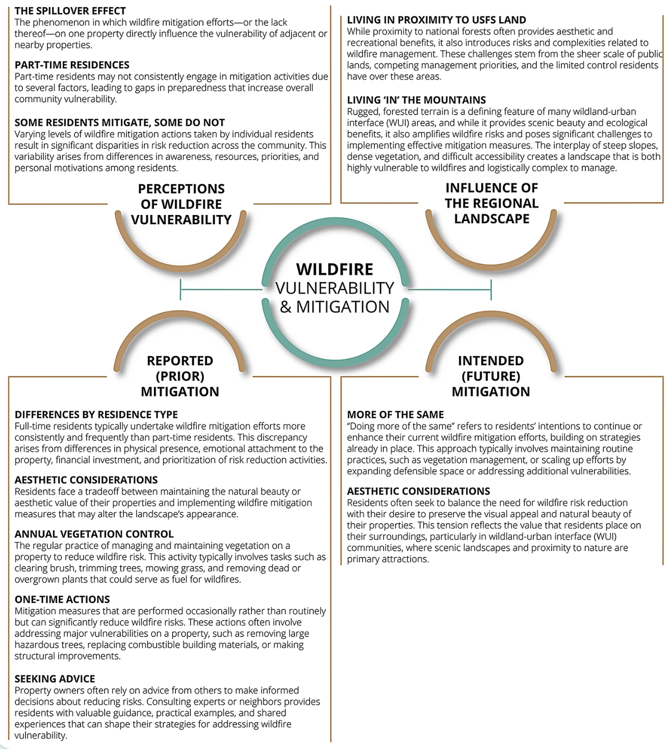
(Figure 2: Structure and description of the themes and sub-themes emerging from the qualitative analyses.)
- Perceptions of vulnerability: Residents emphasized a “spillover effect,” where neighbors’ fuels and (non)‑mitigation, especially part‑time and rental properties, strongly shaped their own perceived risk.
- Influence of regional landscape: Living “in the mountains” and adjacent to national forest was seen as inherently risky, with steep terrain and continuous fuels amplifying concern.
- Previous mitigation: Actions ranged from annual vegetation control and chipping to one‑time major fuel removals and structural hardening (e.g., metal roofs), often balanced against aesthetic preferences and attachment to trees.
- Planned mitigation: Many planned to “do more of the same” (continued thinning, defensible space), again constrained by aesthetics, lot size, and willingness to accept some risk.
To complement these qualitative findings, we conducted a statistical analysis to examine the relationships between WHLA scores and the themes identified in the interviews.
Lot evaluation
The lot evaluation included nine quantitative and three qualitative measures. The majority of parcels (69.2%) required vegetation thinning, and vegetation density was categorized as high on 53.8% of parcels. However, most parcels had a moderate amount of defensible space, with 69.3% having more than 30 feet of clearance around the structure.
Access evaluation
The access evaluation consisted of seven quantitative measures assessing the adequacy of road and driveway width and turn-around capacity for firefighting and evacuation. All parcels met the criteria for adequate road, driveway, and turn-around dimensions.
Structure evaluation
The structure evaluation included ten quantitative and two qualitative measures to assess hazards associated with buildings on the property. All structures had screened vents (≤ ¼ inch) and enclosed eaves. Most parcels had screened chimneys (92.3%) and clean, debris-free gutters (92.3%).
Cumulative WHLA scores
The overall WHLA scores ranged from moderate hazard levels (1–12) to high hazard levels (13–24). The majority of parcels (92.3%) fell into the moderate hazard category, with only 7.7% classified as high hazard. No parcels had WHLA scores exceeding 14, and the mean score across all parcels was 7.9.
Conclusion
Taken together, these results are more complementary than contradictory. The interviews help explain why WHLA scores did not line up neatly with perceptions and behaviors: salient social and landscape cues (neighbors’ fuels, absentee/seasonal ownership, aesthetics, and access) appear to dominate decision making even when structural conditions are not especially hazardous. At the same time, the WHLA data validate that most assessed parcels had several “good practice” features (e.g., screened vents, enclosed eaves) and adequate access conditions, which may reduce the salience of parcel-specific deficits and shift residents’ attention toward vulnerabilities beyond their property line. The two strands also substantiate one another: interview narratives of a “hazard mosaic” (well-mitigated homes interspersed with less-mitigated parcels) align with WHLA evidence of variable lot conditions (e.g., vegetation density and thinning needs), while the statistically null WHLA–theme associations underscore that mitigation choices are not a simple function of a parcel’s score but of how residents interpret vulnerability through social norms, perceived efficacy, and constraints.In short, the WHLA findings situate objective wildfire vulnerability baseline (mostly moderate, with discrete improvement opportunities), whereas the interviews show how socially and physically embedded appraisals can amplify or attenuate action regardless of that baseline. The coherence of these patterns strengthens confidence in the mixed-methods inference that the social and physical environment—not just on-parcel physical vulnerability—shapes perceived vulnerability and mitigation decisions.
By linking parcel-level assessments with resident interviews, this study suggests mitigation decisions are shaped by socially embedded perceptions that often diverge from objective on-parcel hazard. Policies and programs should therefore target assistance and communication by the (mis)alignment between perceived and assessed vulnerability and act at neighborhood/community scales to leverage the important role of social norms. By coupling on-parcel physical vulnerability assessments with qualitative data detailing how residents think and act, this study offers clear guidance on turning multiple sources of vulnerability information into proactive wildfire risk mitigation efforts. These efforts will be needed with unprecedented urgency and scale across the American West in years to come.
Principal Investigators:
Jordan W. Smith, Ph.D.
Director, Institute of Outdoor Recreation and Tourism
Utah State University
Related Research