Fighting Wildfire with PODs (Potential Operational Delineations)
Wildfire is a major factor affecting forests and rangelands in the West. In 2019 about half (49% or roughly $3 billion) of the U.S. Forest Service budget was appropriated to the Wildland Fire Management account. Wildfires threaten the property and lives of the public and first responders, while posing a risk to valuable resources. The 2011 Las Conchas Fire burned 156,293 acres in New Mexico. This is the second largest fire in New Mexico’s history bringing the threats of wildfire into the forefront of this community in north central New Mexico. These threats have led land managers, fire scientists, and agencies to adapt and improve decision-making tools with the goal of reducing risk for fire responders and the public, while simultaneously considering the impacts on ecological processes. In northern New Mexico, Potential Operational Delineations or PODs were implemented to mitigate risk and use wildfire as an ecological tool.
The US Forest Service Rocky Mountain Research Station (RMRS), universities, and other partners have been working together for several years on developing PODs and Quantitative Wildfire Risk Assessments (QWRAs) to improve planning on a multitude of landscapes. In 2018, the Colorado Forest Restoration Institute (CFRI) and RMRS led a strategic wildfire risk planning workshop for the Carson and Santa Fe National Forests, The Nature Conservancy (TNC), Bureau of Indian Affairs, US Geological Survey, and National Park Service. This workshop allowed fire managers and natural resource staff from different agencies to learn about PODs while working together.
In the 2019 fire season, land and fire managers in northern New Mexico managed fire for ecological objectives while implementing the use of PODs to inform fire response efforts. Managers combined PODs and QWRAs, which map the probability of fire occurrence, burn intensity, and effects of highly valued resources and assets, to create Strategic Response Zones (SRZs). PODs, QWRAs, and SRZs create a suite of tools that can be used together for land and fire management.
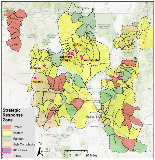
Figure 1: Strategic Response Zones and the seven fires managed using PODs on the Sante Fe and Carson National Forests in 2019. Photo courtesy: United States Forest Service
PODs were used by natural resource managers on seven New Mexico fires which totaled 12,000 acres in 2019. These fires were located across five ranger districts over two National Forests (Sante Fe and Carson). The SRZ indicated that fire could be used to restore ecological conditions on six of the seven fires (Figure 1). In some areas, the use of PODs and SRZs allowed for fuel reduction, forest restoration, and improved forest resilience. Fire management personnel for the Conejos Fire (778 acres) used the POD boundary on the north, west, and east sides of the fire to achieve resource benefit objectives. The local ranger district used PODs to improve their communication with the public and regional leadership during the Cueva and Naranjo fires (1,176 and 1,010 acres respectively). Having been provided with spatial data on Forest Service PODs and SRZs in the fire preseason, the Taos Bureau of Land Management (BLM) office was able to utilize the Amole fire to reintroduce fire to over 1,900 acres, which helped meet forest restoration goals and reduce fuel loads.
The case studies conducted in northern New Mexico demonstrate that PODs can be effective in the decision-making process when combined with other risk assessment tools. These case studies were made possible by the combined effort of multiple partners over the course of multiple years. The applications described exemplify what can be accomplished when various groups collaborate. Following the 2019 fire season, managers continue to work with RRS and CFRI to identify the next steps and discover new products that will assist in decision making. RMRS, CFRI, and Pyrologix (a wildfire risk assessment research firm) have been developing a decision support tool that will efficiently summarize predicted fire behavior, hazards, and highly valuable resources and assets within PODs. Ths product is set to be showcased in the spring of 2020. RMRS continues to work with various partners to assess the influence that the PODs framework has on decision making across several landscapes, which will allow them to determine how PODs are currently being used and present a guide for future POD development in the West.
Resources: Caggiano, MD, O’Connor, CD, & Sack, RB (2020). Potential Operational Delineations and Northern New Mexico’s 2019 Fire Season. CFRI-2002.