008 - Managing Forests for Water Quality: Streamside Management Zones
Water Quality and Forest Management
Throughout Utah, forestlands act as collectors of pure water. Much of Utah’s water supply originates in high elevation forested watersheds. These forests play a vital role in purifying and maintaining clean water for streams, lakes and groundwater. Special care must be taken to protect the water resources when conducting forest management activities on these sites. Protecting the water supplied from our watersheds is everyone’s responsibility.
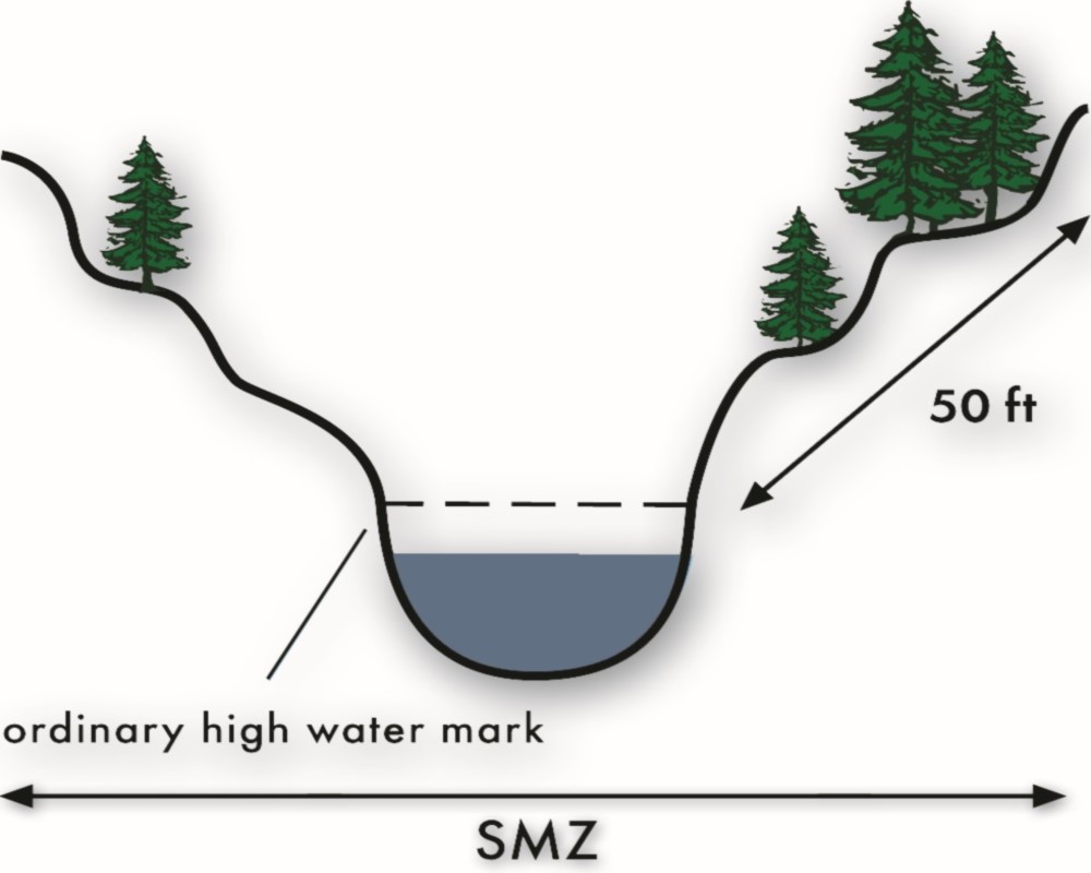
The streamside management zone (SMZ) is an area or strip of land adjacent to a stream or other body of water where management practices are planned and implemented in a manner that protects water quality, aquatic wildlife and wildlife habitat. Trees and vegetation within the SMZ serve as a natural filter to keep sediment out of a stream, reduce soil erosion, and buffer the stream from damage caused by nearby activities such as harvesting of timber, road construction or prescribed burning. The SMZ is not a zone of exclusion where all silvicultural activities are precluded but because of the need to protect water quality and other values, the SMZ is an area where silvicultural activities should be carefully managed.
The Value of Streamside Management Zones
Within healthy streamside management zones, several natural processes occur that help keep our water clean and abundant. These processes include:
- Filtering sediment and nutrients from runoff. As runoff water moves over the ground through plants and plant debris, it slows and drops sediment that it is carrying. This settling process keeps sediment and nutrients from flowing into streams and lakes. It also allows plant roots to take up the nutrients that have dissolved in the runoff and soaked into the soil, further reducing the amount of pollution flowing into lakes and streams.
- Allowing water to soak into the ground. Leaves and twigs from trees and other plants slow surface runoff, allowing water to soak into the soil. This helps reduce peak flow levels in streams and replenishes the groundwater that helps maintain lake levels and stream flows.
- Stabilizing streambanks and lake shores. Trees and other plants along streambanks and lake shores reduce soil erosion because their roots hold the soil together, making it more difficult for currents, waves and runoff to wash the soil away. Plants also lessen the impact of raindrops on exposed soil, decreasing erosion.
- Shading streams. In most cases, trees and other plants along streambanks are desirable to shade streams, keeping the water cool for aquatic life in the summer.
- Providing food and habitat for aquatic organisms. The base of the food chain for aquatic organisms in small forest streams is fallen leaves, twigs and other organic debris from trees. Aquatic invertebrates which graze and shred these materials are eaten by small fish, which are in turn eaten by larger fish as well as mink, kingfishers and other wildlife. Large woody debris provides hiding cover for fish, both predator and prey. Depending on its location, large woody debris affords shelter from excessive currents and forms scour holes valuable to sport fish species such as cutthroat, rainbow and brown trout.
Forest Water Quality Guidelines
Utah’s Forest Water Quality Guidelines (FWQGs) are a collection of voluntary, field-applicable practices for use during forestry activities to protect soil and water resources. They are designed to minimize non-point source pollution such as sedimentation and erosion associated with forestry activities. For more information about the FWQGs and their application, contact your local Forestry, Fire and State Lands area office. A technical guide of the FWQGs is available.
Identifying the Streamside Management Zone
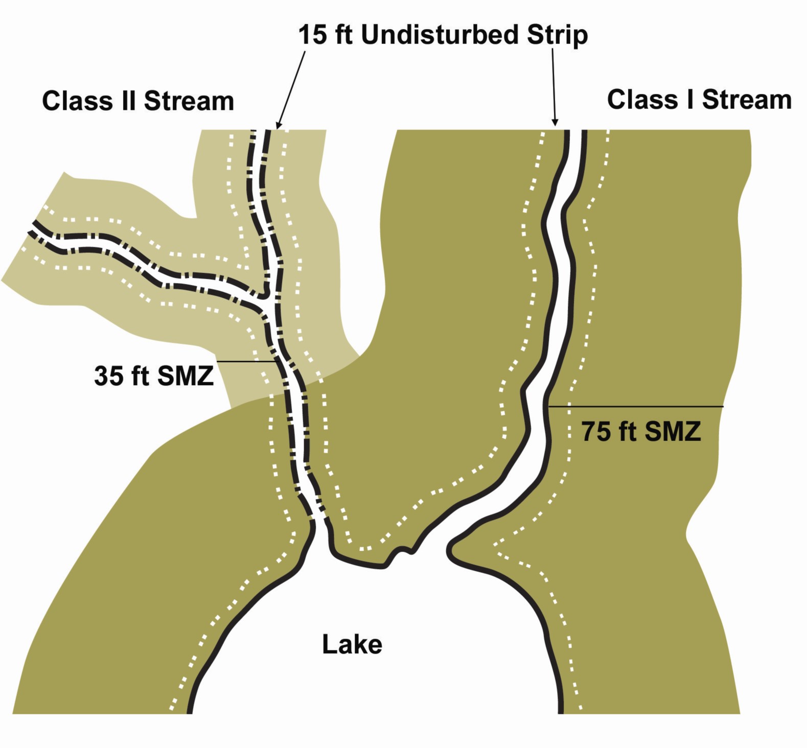
Sample SMZ Layout with Slopes < 35%
The streamside management zone is an area of land adjacent to a stream, river, lake, or wetland, where activities on the land are likely to directly affect the quality of water in the water body. SMZs are measured from the “Ordinary High Water Mark” on each side of the stream. SMZ widths differ based on the type of water body involved, and the slope of the land next to the water body. For determination of SMZ width, Utah’s Forest Water Quality Guidelines define Class I and Class II streams. (This stream classification differs from those used by the Utah Division of Water Quality and the Utah Division of Wildlife Resources.)
Class I Streams are streams or other bodies of water used for domestic water supply and/ or the spawning, rearing and migration of fish, including impacted streams with recovery potential for a fishery. Also included are perennial streams that contribute significant flow to downstream fisheries. Seventy-five feet is the recommended minimum slope distance for the streamside management zone on slopes of less than 35 percent. If slope exceeds 35 percent, the width of the SMZ increases to 100 feet.
Class II Streams are all streams that do not meet the Class I definition and are identifiable in the field as having a defined channel of bed rock, sand, gravel, or rocky material and definite banks. They generally have an ordinary high water mark and confine and conduct continuously or intermittently flowing water. Also included are reservoirs, lakes, and ponds greater than one-tenth acre that do not support fish or provide domestic water supply. Thirty-five feet is the recommended minimum slope distance for the streamside management zone on slopes of less than 35 percent. If the slope exceeds 35 percent, the width of the SMZ increases to 50 feet.
If a wetland (such as a seep, spring, wallow, marsh or bog) is adjacent to the stream channel, increase the width of the SMZ to include the wetland. Even if standing water is not present, the presence of hydrophytic (water-loving) plants identifies an area as a wetland.
Within each streamside management zone, no matter the width, the first 15 feet next to the ordinary high water mark should be treated as an undisturbed strip. This strip of undisturbed litter, duff, grass and vegetation is very efficient in filtering sediment from surface runoff. Most silvicultural activities should not take place within the undisturbed strip.
Once you have delineated the SMZs around the streams and waterbodies on your property, clearly mark the zones and the undisturbed strip with flagging, paint or signs. Use a marking method that will withstand changing weather conditions.
Minimum Recommended SMZ Widths
| Stream Category | Slope < 35% | Slope > 35% | Undisturbed Strip |
|---|---|---|---|
| SMZ Class I | 75 feet | 100 feet | 15 feet |
| SMZ Class II | 35 feet | 50 feet | 15 feet |
Slope Distance and Percent: Slope distance is measured along the average slope or lay of the land; imagine a measuring tape stretched up a hill in a straight line. Percent slope is the average slope of the land expressed in feet of rise or fall for every 100 feet of horizontal distance. A 35% slope rises 35 feet in 100 feet horizontal distance.
Illustrations of Stream Management Zone Width
When laying out the stream management zone on your property, be aware that the zone varies with the slope adjacent to the stream. Therefore, the SMZ along one stream or water body may change width several times. To be sure equipment operators have no question about the SMZ boundary, clearly mark it and the undisturbed strip at frequent intervals with plastic flagging, paint or signs.
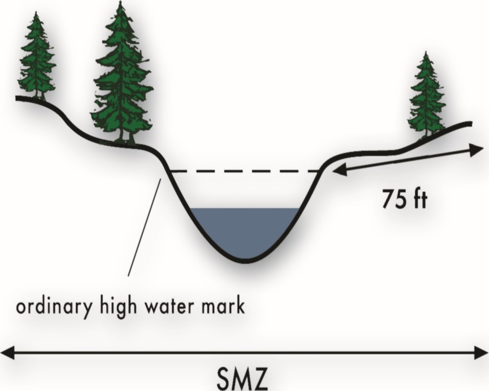
SMZ for Class 1 Stream, Slope < 35%
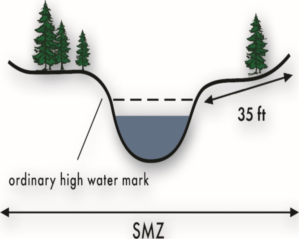
SMZ for Class 2 Stream, Slope < 35%
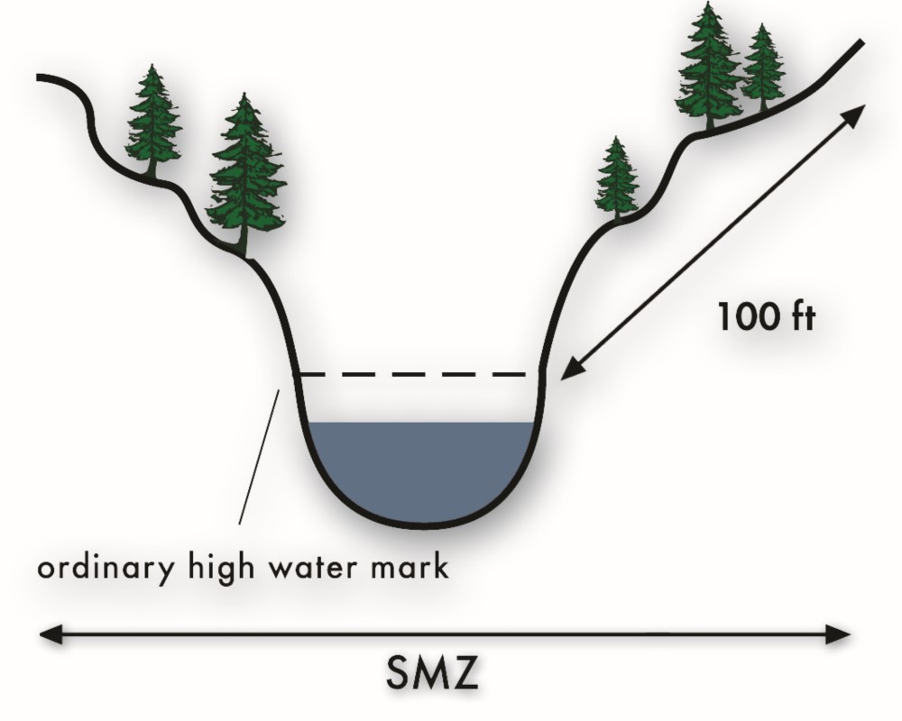
SMZ for Class 1 Stream, Slope > 35%
SMZ for Class 2 Stream, Slope > 35%
Recommended Forest Practices Inside The Streamside Management Zone
The following is a partial list of practices which may be applicable to your forest management project. Implement the appropriate practices to protect water quality before, during and after the project is complete. Particular attention should be paid to the SMZ in the construction and maintenance of roads and stream crossings.
Before the Project
- Designate the streamside management zones using recommended distances. Recognize that the width may vary according to the slope adjacent to the stream at any point. Include an undisturbed strip of 15 feet along each side of the water bodies to filter runoff. Clearly mark the SMZs and undisturbed strips with weatherresistant paint, flagging, or signs.
- Apply the recommendations for road construction and stream crossings listed on the following page.
- Retain a diversity of tree species and age classes in the SMZ. Keep enough mature trees to avoid potential regeneration problems.
- Clearly designate trees to be cut in the SMZ (do not leave it up to the operator), and do not clearcut in the SMZ. Leave sufficient trees to provide bank stabilization, shade and a future source of large woody debris.
Shading Recommendations for SMZs
| Stream Category | Recommended Minimum Standard for Residual Basal Area | Recommended Minimum Standard for Canopy Cover |
|---|---|---|
| SMZ Class I | 50 ft2/acre | 50% |
| SMZ Class II | 25 ft2/acre | 25% |
Throughout the Project
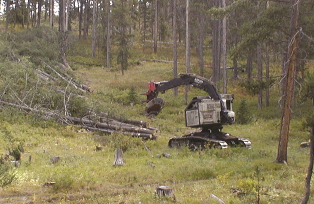
Use of a feller-buncher and directional felling can help minimize soil disturbance in the SMZ.
- Minimize disturbances that expose mineral soil in the SMZ.
- Deposit and stabilize excavated material on stable sites outside of the SMZ.
- Avoid use of heavy equipment in the SMZ to minimize ground disturbance. Use winching or end-lining skidding techniques to remove logs from the SMZ.
- Maintain sufficient ground cover within the SMZ to trap sediment before it enters any watercourse.
- Use directional felling in the SMZ. A boom fellerbuncher can also minimize disturbance.
- Avoid felling trees into streams and keep slash out of all water bodies. Limbing of felled trees should always be done above the high water mark.
- Control skidding to prevent stream channel damage and to preclude build-up of destructive run-off flows or erosion in sensitive areas such as the SMZ, wetlands or meadows.
- Keep slash (logging debris) out of the SMZ. If slash does occur in the SMZ, do not machine-pile or burn.
After the Project
- Remove any material which adversely affects the natural flow of water. Remove in a manner which causes the least disturbance.
- Avoid broadcast burning in the SMZ unless specifically identified as the proper management treatment.
- Restrict mechanical site preparation in the SMZ. Encourage natural revegetation, seeding and hand planting in the SMZ.
- Do not use, mix, store or handle hazardous or toxic materials in the SMZ. Do not clean equipment or containers of fuels, pesticides or herbicides in or near streams or in the SMZ.
- Avoid pesticide use in the SMZ, and never apply it so it falls directly on streams or other water features. If necessary to use a pesticide or herbicide in the SMZ, utilize spot treatments; do not broadcast over a large area.
Constructing Forest Roads and Stream Crossings in the Streamside Management Zone
Recommendations and Resources
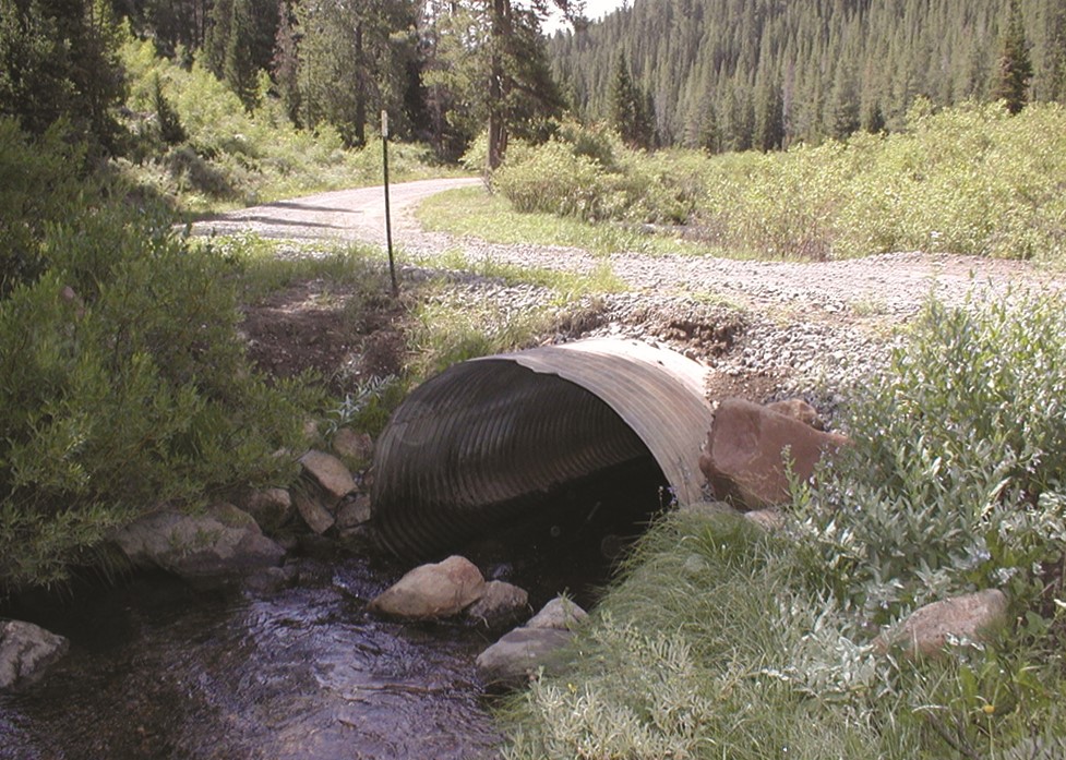
A properly sized and placed culvert will handle 50 year flood events and allow safe fish passage.
The construction of a road or stream crossing potentially has the greatest impact of any activity within a streamside management zone, due to the exposing, movement and compaction of large amounts of soil. Greatest care must be taken when crossing a stream or placing a road inside the SMZ. Adhering to the following recommendations will minimize the impact on water quality.
- If possible, locate roads outside of the SMZ. Skid trails and landings should not be located in the SMZ.
- Do not side-cast material into streams or wetlands when constructing or maintaining roads.
- Plan stream crossings carefully, and minimize the number of stream crossings. Streams should be crossed at a right angle to the channel. If a stream crossing needs to be built, contact the Utah Division of Water Rights to obtain the proper permit (see box below).
- When crossing Class I or Class II streams, structures such as culverts should be, at minimum, 15 inches in diameter, and be the appropriate size to allow full surface flow of the stream for the entire life of the structure, including a 50-year flood event. Structures for Class I streams should be designed and constructed to allow unrestricted fish passage. The FWQG technical manual contains specific guidelines for sizing culverts.
Stream Crossings: A Permit May be Required
Use stream crossings only when absolutely necessary, as poorly located or constructed stream crossings are costly and may contribute to sedimentation and erosion. Select a site for a stream crossing before the road system is laid out or planned, allowing the road system to be designed for the best approach to the crossing. The profile of the streambed should not be changed when constructing crossings. Select the most appropriate stream crossing structure using the following criteria: stream size, cost, maintenance requirements and whether temporary or permanent. Culverts, bridges and fords are all methods used to cross streams. A permit from the Utah Division of Water Rights is required for any stream bank alteration.
If you need to construct a stream crossing, contact:
Utah Division of Water Rights
P.O. Box 146300
Salt Lake City, UT 84114-6300
Phone: 801-538-7240
A Guide to Building Forest Roads
A very informative USDA Forest Service publication, “A Landowner’s Guide to Building Forest Access Roads” can be found on the USDA website. This booklet gives technical instructions and specifications for building forest roads and stream crossings.
Published June 2004.