Managing Aspen in Western Landscapes
September 21-23, 2004, Hunter Conference Center, Cedar City, Utah
Wednesday, September 22, 2004 | Morning Session

Aspen Ecology in the Western United States
Aspen, the most widely distributed tree species in North America is a vital component of almost every forest ecosystem in western North America, providing vegetation diversity, wildlife habitat, livestock forage, specialty forest products, and highly desirable scenery. Aspen’s ability to grow in full sunlight and vegetatively regenerate via root suckering allows it to thrive following fire, or other disturbance. Its unique clonal growth habit allows the expression of genetic characteristics on a large scale in western landscapes, either as stable aspen forests, or mixed with conifer species. Although aspen is susceptible to many diseases and damaging agents, it persists through periodic natural regeneration episodes driven by disturbance. Deteriorating aspen stands result when this natural cycle of renewal is interrupted, as has happened with wildfire suppression and excessive utilization of young aspen by browsing animals. The aspen regeneration triangle, representing the critical factors of hormonal stimulation, proper growth environment, and protection of new regeneration can serve as a useful guide in planning management actions in aspen forests.

Aspen Ecology and Life Zones of Southwestern Utah
(Abstract not available)

Variability in Historical Aspen Dynamics: Implications for Current Restoration Priorities
Aspen occupies millions of acres in the west, occurs in a wide variety of environmental settings, and exhibits a diversity of successional dynamics. Four general types of aspen dynamics can be recognized: stable or persistent aspen, seral aspen in no imminent danger of being lost, seral aspen in danger of disappearing within a single generation, and deteriorating aspen being replaced by herbs or shrubs. I will present examples of each type of aspen forest, suggest some of the major spatial and geographical patterns of distribution of each type, and evaluate each in terms of the urgency for restoration.

Linkages Among Wolves, Ungulates, and Aspen Recruitment
Using historical aspen (Populus tremuloides) diameter data and aspen increment cores collected in 1997 and 1998, we analyzed aspen overstory recruitment in Yellowstone National Park (YNP) over the last 200 years. We found that successful aspen overstory recruitment occurred on the northern range of YNP from the middle to late 1700s to the 1920s, after which it essentially ceased. We found that aspen recruitment ceased during the same years (1920s) that gray wolves (Canis lupis) were extirpated from the park. We hypothesize that wolves may positively influence aspen recruitment through a trophic cascades (top down) affect on elk (Cervus elaphus). For prey species such as elk, foraging decisions made under the risk of predation may differ from an optimal foraging strategy based only on maximizing nutrient intake. We suggest that predation risk effects can have a specific influence on elk herbivory at multiple spatial scales and that elk may have historically avoided foraging in certain aspen and riparian habitats due to the risk of predation from wolves.
In 1999, we initiated a long-term study of the influence of reintroduced YNP wolves on elk herbivory and recruitment of aspen as well as other woody browse species. Since then, we have found no recruitment of aspen on upland sites except for areas protected from browsing (e.g. jackstrawed woody debris). In valley bottom riparian areas, we found aspen releasing on a few very high risk sites (i.e. canyon, gully). These releasing aspen (2-4 m tall with 2003 seasonal growth) are taller than previously documented maximum heights for young aspen in the northern range following the reintroduction of wolves. Results appear to (1) indicate a trophic cascades effect, based on predation risk, at a local scale and (2) illustrate that terrain features may play a supportive role in aspen recruitment by providing increases in predation risk to elk. In additional areas, willow (Salix spp.) has been growing taller since wolf reintroduction.
Overall, these results offer rare empirical evidence on the indirect effects of a top carnivore in a terrestrial food chain and supports theory on predation risk effects and trophic cascades. If the aspen and willow of Yellowstone continue to grow taller and expand in canopy cover, the numerous benefits to ecosystem processes will include stream channel stabilization, flood plain restoration, and higher water tables. Through a trophic cascades effect of improved habitat, wolves may be beneficial to numerous species of vertebrates and invertebrates such as fish, birds, beaver, and butterflies, as well as many other species of wildlife. For more information, see “The Aspen Project” website.

Talking Trees: The Carved Legacy of Basque Sheepherders
Historians are used to digging in archives, but the idea of having to go into the mountains and get primary information from reading trees, is totally alien. Yet, there are hundreds of aspen groves in the American West that contain precise, localized, and unpublished ethnohistoric sources regarding the sheep industry in the last century. The arborglyphs are an autobiographical monument to the history of the common man, the Basque sheepherders, who actually did most of the sheepherding work.
Management Track
Aspen Restoration from the Role of a District Ranger
How do you get an aspen management program started from scratch? How do we take science and turn it into management? Aspen has declined by 64% in Montana (Jodie Canfield, PowerPoint presentation, 2004). The aspen sites on our district serve as unique sites of diversity and have been neglected for many decades. By developing partnerships with research, peers, and other ranger districts we can start building a successful program. Start with what you have to work; that may be a low budget and volunteers but at least you get started. Try new approaches and use known methods of fencing and prescribed fire that deliver results. On the White Sulphur Springs Ranger District we are starting to develop some ideas to sprout our aspen management program.
View Tim's paper, A District Ranger’s Perspective on Aspen Restoration.
Aspen Regeneration: How Many and How Much?
Aspen management is beginning to gain momentum in the Intermountain Region as we look at ecosystem processes and function. Restoring aspen to landscapes dominated by conifer forests has become an emphasis toward restoring healthy forests. One of the major questions that are asked is, “How many suckers do I need to establish a new aspen stand.” The second question that follows is, “What do I have to do to get full coverage of aspen because I have some sites that don’t regenerate well.” The basis for the numbers and amount of aspen regeneration within a treatment area are driven primarily by the project objectives described in the proposed action. Aspen generally has the potential for great numbers of suckers following disturbance. Suckering has been noted within a few weeks following fire. The Dixie National Forest has documented as many as 350,000 suckers per acre. I have noticed that people tend to underestimate the potential for suckering and want to manage aspen stands at extremely low numbers. This can present a big problem where grazing ungulates can deplete aspen regeneration to the point the aspen clone is lost. At the same time people want to overestimate the potential for aspen recovery across a stand or landscape. We must gain an understanding of the distribution of the live remnant trees and potential where rootstock may no longer exists. We have noted many cases where aspen only occupies a portion of a stand. As vegetation managers we need to gain a greater understanding for aspen needs and where we have the greatest opportunity for success. We must recognize and deal with potential conflicts with other resource uses and understanding the potential for aspen regeneration and how that contributes to the establishment of new aspen stands.

Aspen Regeneration on the Ashley National Forest
Aspen has generally regenerated after clear-cut harvest and fire on the Ashley National Forest. Examples of regeneration and a few cases with little or no regeneration are demonstrated by photography.
Management Recommendations or Restoring Cedar Mountain Aspen
Aspen clones of an aspen-dominated community on Cedar Mountain in southwestern Utah are deteriorating, some having experienced high mortality coupled with insufficient regeneration. The objectives of this study were to (1) determine if decadent, non-regenerating mature aspen stands could be regenerated by clearcutting; (2) determine the extent of ungulate use of regenerating aspen ramets; and (3) develop management recommendations. Clearcuts were made in late summer of 2001 in 10 different clones that exhibited various levels of decline on a continuum from relatively healthy to extremely deteriorated. Nested wildlife/livestock exclosures were constructed in each clearcut plot, as well as in a corresponding uncut control plot. In the fall of 2002, regenerating suckers were counted. In addition, vigor and ungulate utilization of these suckers were measured in the wildlife and livestock exclosures, as well as in an unprotected portion of the clearcut and control plots.
Regeneration of the clearcut plots ranged from none in the most decadent clones, to 75,000 stems/ha in the least decadent clone, and was significantly greater than the control plots. Greenhouse trials found no difference in regenerative abilities between clones, however regeneration success in the clearcut plots was significantly related clone basal area prior to treatment. Vigor, as measured by height of the suckers, was 1.5 to 2.1 times greater in the clearcut plots than in the control plots. Seventy-three percent of the suckers in the unprotected portion of the plots were heavily browsed, while only 12% were not browsed. As a result of severe decadence and browsing pressures, which may limit the clone’s ability to successfully restock and remain on the landscape, management recommendations for Cedar Mountain aspen clones were developed utilizing regenerative status, basal area, and browsing pressure.
Aspen Restoration in California: Examples from the Eagle Lake Ranger District, Lassen National Forest
The Eagle Lake Ranger District (ELRD) of the Lassen National Forest has developed an aspen restoration program that has been recognized as the most progressive in California. This program was initiated due to observed declines in health and distribution of aspen stands on ELRD. The overall goal of the program is to prevent further loss of aspen on ELRD. Objectives of this program are to, 1) map and assess all aspen stands on ELRD, and, 2) implement restoration treatments on all ELRD aspen stands. The perimeter of each inventoried aspen stand is delineated using Global Positioning Systems (GPS), and the condition of each stand is assessed using risk factors adapted from Bartos and Campbell (1998). We present inventory and monitoring data collected to date, and will discuss lessons learned in our implementation of restoration projects.

Analysis of Aspen Stand Structure and Composition in the Western U.S.: Implications for Management
Aspen communities in the western U.S. are considered at risk because of low levels of disturbance (primarily fire) and high levels of herbivory by wild and domestic ungulates. Although estimates of the affected area vary, there appears to be a trend toward the loss of aspen-dominated stands West-wide. In some cases the loss is caused by succession, with shade-tolerant conifers becoming dominant. On dry sites where aspen is considered to be the climax, deterioration of aspen stands and loss of regeneration may lead to a conversion to sagebrush or grassland. As a result, regeneration efforts have tended to classify aspen stands according to two “classic” models: aspen as seral to conifer communities, and pure aspen as a climax community. However, there is evidence that other stand dynamics models exist in stands having an aspen component. The discovery of very old aspen (275-300 years) and multiple aspen age classes in spruce-fir forests suggests that aspen may persist in these stands through gap-phase replacement. In stands where aspen and lodgepole pine are only tree species, dominance may shift in favor of either species depending on the type and intensity of disturbance. Aspen is also a common associate of ponderosa pine, and the two species may coexist over time under a “maintenance” fire regime. Data from 3371 Forest Inventory and Analysis plots, located in stands with an aspen component and covering the range of aspen west of the 103rd meridian in the lower 48 United States, are being used to classify stands according to composition and structure. The results of this analysis should aid management decisions by providing a method for classifying stands according to their successional status, and may suggest alternative stand dynamics models by which aspen may be maintained on the landscape.
Research/Assessment Track

Assessment of Aspen Condition of the Okanogan and Wenatchee National Forests
Aspen stands occupy less than 1 percent of the Okanogan and Wenatchee National Forests but the species is an important resource. 105 aspen stands considered to be representative of the aspen population on the Forests were surveyed in the summer of 2003 to assess their condition. Most aspen stands occupy small areas and contain small numbers of stems. 56% of the stands were estimated to cover 2 acres or less, 28% covered 5 or more acres. 56% were rated as stable, 41% were classed as successional to conifers, and 3% were rated decadent. Similarly, area occupied by living aspen stems was classed as 43% stable, 19% expanding, and 38% retreating. 24% of the stems were dead from a variety of causes. 15% of the mortality could not be identified to causal agent, 5% were killed by fire, but less than 1% was killed by diseases. 7.4% of the sprouts were dead. 47% of the stands had active sprouting. 57% of the sprouts had been browsed. Elk were believed to be responsible for the almost total lack of seedling size aspen stems on the southern-most District. Many damage agents, including canker fungi, decay, wood borers, and ungulates were found affecting aspen stems.
Coauthor Roy Magelssen
Development of a Protocol for the Ecological Assessment of Aspen
Resource managers across the West have a heightened interest in aspen issues since government mandates are increasingly directing land managers to protect the biodiversity of flora and fauna on public lands. Among those actively working on aspen issues, there is an interest in developing consistent inventory, assessment, and monitoring protocols in order to make science-based management decisions, share data more easily, produce a consistent evaluation of treatment results, and develop training programs for management and field staff.
Because of this heightened interest, the Aspen Delineation Project, a collaborative effort of the U.S. Forest Service Pacific Southwest Region, California Department of Fish and Game, and the California State Office of Bureau of Land Management, has undertaken development of a consistent approach for collecting data about ecological condition of aspen stands on agency lands.
Protocols for determining ecological condition were developed and field tested by review groups. To date, units from seven state and federal agencies have collected data using the same protocols and field form.
The effort has focused on the identification of key indicators of ecological condition within aspen stands. The key indicators were established through extensive review of aspen research. Identification of the range of factors that create or affect those indicators were then incorporated into the protocols. Resulting ecological assessments conducted through the protocols describe stand structure, indicate unique stand management conditions, and record factors that might be putting stands at risk.
Using Forest Inventory Data to Assess Aspen Health in the Western United States
The health of the regional aspen (Populus tremuloides Michx.) community is currently a disputed topic in the Interior West. Numerous recent studies have addressed “aspen decline,” purportedly a regional phenomenon, using landscape-level analyses. While we assume that aspen conditions vary throughout the Interior West we believe a study of a regional forest health issue should employ a systematic plot network as a complement to local empirical studies. The study has four primary objectives: 1) Conduct an empirical assessment of aspen conditions across Utah using FIA (USDA Forest Service’s Forest Inventory and Analysis) annual inventory data; 2) Refine and enhance statistical methods employed in previous studies for potential export to other regional aspen assessments; 3) Assess the utility of extensive data sets in addressing large-scale forest health issues; 4) Place the Utah example in the context of the greater western U.S. aspen community.
In the Rocky Mountains “healthy” or “stable” aspen communities are regenerating vegetatively at relatively short time intervals (20-80 years) via disturbances such as fire, wind, avalanche, or management actions. Forest assessments from examination of FIA stand structure and condition variables (species, crown position, dbh, stand age, regeneration, tree damage, and recent disturbance) at a single point in time provide a ‘window on the past’ as to whether aspen is actively sustaining itself or declining. Variables that prove to have significant relations with NMDS (Nonmetric Multidimensional Scaling) ordinations of stand structure and composition will be combined into a synthetic aspen stability index through multivariate statistical analysis. Results presented here quantify the extent of aspen stability, and hence provide a current assessment of aspen community health in Utah.
Image Not Available
Barton R. Stam, Graduate Research Assistant, Utah State University, Logan, Utah, Coauthors John C. Malachek, Dale Bartos, James E. Bowns, and E. Bruce Godfrey, (Presented by Dale Bartos)
Quantifying Losses of Understory Forage in Aspen Stands on the Dixie and Fishlake National Forests
The Western United States has lost up to 60% of its historic aspen (Populus tremuloides) stands over the last century, probably as a result of the successional tendency of aspen to be replaced by coniferous species in the absence of periodic fires. One of several major impacts of this change is the loss of understory forage as conifer canopy cover increases. We measured understory biomass in aspen stands ranging from 0% to 81% absolute conifer cover in the canopy and found that understory production declines exponentially as conifers replace aspen. We also did an economic analysis to determine the value of the forage that is not being produced by aspen sites due to the presence of coniferous species within the tree canopy. Study results indicate significant losses in forage, marketable through the sale of livestock, and losses in revenue generated through grazing fees for the USDA Forest Service.

Aspen Regeneration Across the Southern End of the Cerro Grande Burn
In the spring of 2000, the Cerro Grande fire burned nearly 19,000 ha (48,000 acres) of aspen (Populus tremuloides) and mixed conifer forest on the east side of the Jemez Mountain in northern New Mexico. During winter, the southern part of the burned area can host many of the mountain range's 4,000 elk (Cervus elaphus). Previous work has documented a range of aspen regeneration heights and browse intensities due to this elk population. To quantify the post-fire variation in aspen regeneration and to examine the relationship between site characteristics and the level of browse, we focused on the southern portion of the burned area. In September 2002, we surveyed 58 random 10 m x 10m (33 ft x 33 ft) plots in the study area. We recorded the maximum sprout height; number of sprouts (up to a maximum of 200); sprout condition (browsed or not browsed); elevation, slope, aspect; dominant pre-fire overstory tree species; estimated current percent canopy cover; smallest Diameter at Breast Height (DBH) live tree-size (> 4 cm DBH) aspen; and elk and deer pellet groups. For plots with aspen sprouts, we observed a correlation between the percent browsed shoots and measured maximum height after 3 years (r2 = 0.45, n = 31, F = 23.37, p < 0.0001). Maximum sprout height was correlated with UTM Easting (r2 = 0.21, n = 31, F = 7.66, p = 0.0097), while inversely correlated with UTM Northing (r2 = 0.15, n = 31, F = 5.12, p = 0.0313) and elevation (r2 = 0.15, n = 31, F = 5.29, p = 0.0289). Northing and slope together explained the measured maximum shoot heights after 3 years better than other predictors (r2 = 0.31, n = 31, F = 6.36, p = 0.0053). The impact of elk browsing on aspen regeneration on gentle slopes in the northeastern part of the study area is clearly exemplified by aspen sprouts over 4 m (12 ft) tall within protective exclosures four years after the fire, while outside elk browsing is preventing aspen sprouts from getting much above ankle-level. In one high burn-intensity area, where the Cerro Grande fire killed all trees, aspen spout density has dropped from several thousand sprouts/ha in late 2000 to nearly zero/ha over a 3.1-ha (7.7-acre) area in 2004 years. Considering that annual elk ranges in the eastern Jemez Mountains are most concentrated on the Valles Caldera, our observations suggest slope may be as important as distance from the Caldera in determining levels of browse on aspen sprouts. Because of the highly browsed structure and decreasing spout density of some aspen clones on gentle slopes, future work should examine future sprout density and heights across the range of sites characteristics. Such information may provide the data needed to make longer-term predictions about aspen regeneration in the study area.
Ecology/Dynamics Track
Small Aspen Stand Dynamics in the Elkhorn Mountains
In an effort to better understand the dynamics of small aspen stands in dry habitats, the Slim Sam aspen project, located in the southeast portion of the Elkhorn Mountains, was initiated in 1999. Eighteen aspen stands were inventoried. Before treatment, on average, there were about 4 live sprouts per 100 square feet and aspen stands were generally in a state of decline. The factors contributing to the decline in the Slim Sam project area included shading from conifers, old age, and browsing and mechanical damage from livestock, moose, and elk.
Eight stands were burned in the spring of 2002. Six of the burned stands were fenced, with 7-foot high wildlife fencing during the summer of 2002. In 8 of the 18 stands, conifers were removed and placed around the outside of the stand to provide some protection from browsing animals. Two of the stands were not treated. Following the initial treatments, ground cover and sprout densities were assessed for 2 field seasons. This presentation summarizes the dynamics of different treatments in isolated aspen stands and compares costs and effectiveness of treatment types.

Aspen Decline in Northern Arizona
An accelerated decline of aspen communities has recently occurred across northern Arizona, following two defoliation events and several years of drought. The Southwestern Region’s 1998 aerial detection survey showed a doubling of defoliated aspen acres (>85,000), compared to previous years, followed by another doubling in 1999 (>170,000). Although 1998 defoliation was caused by foliar insects and pathogens, the 1999 defoliation was due to frost damage following a severe June snowstorm, which occurred across most of Northern Arizona. Since 2000, aerial surveyors have switched from reporting acres defoliated to acres in decline, the latter marked by thinning crowns and mortality. Many small lower elevation clones appear completely dead. We began evaluation and monitoring of affected aspen at the stand level on the Coconino National Forest (NF) in 2003, followed by the Apache-Sitgreaves NF in 2004. This monitoring project describes mortality levels, regeneration condition, and stand and site variables that are influencing decline. Preliminary results show that elevation, which varies from 6,800 to 9,300 feet, is a key factor in both tree species composition and severity of decline. Lower elevation sites (<7,500 feet) are on northerly aspects and are dominated by aspen with a ponderosa pine and oak component. In some sites, more than half the overstory aspen died in the past 3 years and more mortality is expected as many trees have only 10 to 30 percent of the original crown left. Higher elevation sites were on various aspects with a mix of conifer species and a higher ratio of live to dead aspen. Since decline appears to be progressive, remeasurements will determine detrimental levels of crown dieback. Aspen regeneration is slight, especially at lower elevations, but ungulate damage is rampant. A few sites had 100 percent browse damage. The large die-off of mature aspen trees in many lower elevation sites coupled with browsing by ungulates is expected to result in type conversion of many ecologically unique and important sites across the state.
The Use of Repeat Photography to Document Changes in Aspen Communities in the West
Historical repeat photography provides valuable data on long-term vegetation change and land management practices. Repeat photography is also of great educational value because it is easily interpreted by the general public. To date, 800 photo sets have been repeated in Southern Utah and placed on the Utah State University Extension web site (http://www.ext.usu.edu/rra). By systematically evaluating vegetation changes in these photos some clear trends emerge; range conditions have improved, soil erosion has decreased, riparian and stream conditions have improved, while conifers, pinyon-juniper and sagebrush have greatly increased in area and density. Aspen is depicted in 223 repeat-photos in South-Central Utah. In 64% of the photosets, aspen declined, while it remained unchanged in 27% and increase in 9%. This is similar to other research that has reported a major decline in aspen across the Intermountain West. Where aspen declined, it usually was replaced by invading conifers. Conifers were depicted in 221 repeat-photosets and in 92% of those images conifers increased markedly. To stop the decline of aspen and return it to its former abundance, disturbance mechanisms must be instituted that remove conifers and stimulate aspen suckering, controlled burning is the preferred alternative in many situations, however where burning is not practical, mechanical means can be used to restore aspen.

The Role of Forest Insects and Diseases in Aspen Ecology
A forest decline in is often described as a syndrome involving multiple abiotic and biotic factors leading to the death of trees. Many agents can cause stress contributing to aspen forest decline including abiotic agents such as drought or frost, and a wide range of biotic agents including grazing animals, humans, and forest insects and diseases. Insect and disease incidence in aspen the Intermountain Region ranges from 18 to 85% in trees over 5” DBH from surveys conducted on several national forests, but the actual rate of mortality caused by these native organisms has only been examined in a few areas by repeated measurements over time. Where they have been reported, average annual aspen mortality rates varied from 1.1 to 5.2 percent on trees between 2.5 and 30 cm DBH. Insects and diseases can play a wide range of roles in aspen forest ecology, and the roles they play are different in young suckers versus large stems. They can cause outright mortality or contribute to decline or cause insignificant minor damage. For example, the impact of an outbreak of defoliating insects or foliar fungi can stimulate a clone to produce new sucker sprouts or contribute to mortality if additional stresses are present. Recognition of the roles that all contributing agents play in aspen decline is critical to future successful aspen management.
Image Not Available
Don Okerlund, Interdisciplinary Team Leader, Fishlake National Forest, Richfield, Utah
Monroe Mountain Ecosystem Restoration Project, Richfield Ranger District, Fishlake National Forest
The Final Environmental Impact Statement describes the analysis completed on the Monroe Mountain Ecosystem Restoration Project area. The proposed action and action alternatives considered in detail are consistent with current management direction. Each alternative responds differently to the issues associated with the Proposed Action.
The purpose and need for action in the project area is to: 1) restore the abundance of aspen ecosystems where losses occurred because of changed disturbance regimes and increased ungulate pressure, 2) work towards improving watershed conditions that favor long-term improvement of riparian areas and water quality, 3) reduce the risk of large, intense episodes of wildland fire in the mixed conifer/aspen stands, 4) reduce the potential of epidemic level spruce beetle outbreaks in spruce/fir stands, 5) contribute to the restoration of the grass/forb ecosystems to improve habitat for wildlife and livestock, and 6) provide timber products to support local economy, while performing ecosystem restoration.
Two significant issues were identified through the scooping process: the effects of the proposed activities on the character of the Roadless Area Review Evaluation II Inventoried Roadless Areas (RARE II IRA’s), and effects of timber harvest and associated activities, prescribed fire, road construction, and herbicide treatments on water quality and fisheries habitat. Five alternatives, including a “No Action” alternative, were developed to respond to the purpose and needs identified above. In response to the water resources and fisheries significant issue, several watershed improvement projects have been identified that would be common to all action alternatives.
Burn Severity Effects on Quaking Aspen Regeneration
Western quaking aspen (Populus tremuloides) is a disturbance species and has been perpetuated on site for extended periods of time by fire, disease, and other types of disturbances. Where aspen initially existed, it will reoccupy and stabilize sites after burning. Initial data obtained by Forest Inventory and Analysis (RMRS’s RWU-4801) shows there has been a 50-95% decline in aspen dominated lands in the Interior West since European settlement. Most of this decline can be attributed to the efficiency of management to minimize natural occurring fires and to the loss of fine fuels by grazing animals both domestic and wildlife. This lack of burning has allowed natural succession to occur, which causes aspen to change to conifer or shrub dominated sites. The fires of 2000 & 2002 allowed us the opportunity to study the impact of fire on late successional aspen.
Aspen sampling during the summer of 2003 documented first-year response of the different burn severities found within the Battle Creek (SD), Hayman (CO), Million (CO), Missionary Ridge (CO), and Sanford (UT) fires that occurred in 2002. The Jasper fire (2000), in South Dakota, was also sampled. Observations included the type of damage to the aspen suckers from disease, insects, wildlife, and weather. In addition, it was noted if domestic or wild ungulate signs were found in or adjacent to the mil-acre sample plots.
Burn severity (relates to the amount of fuels consumed and damage done to a site by fire) had a consistent impact on initial response of aspen regeneration following the wildfires of 2002. Generally, low severity sites produced the greatest amount of regeneration, followed by moderate severity, and then highest severity. Unburned sites usually produced the fewest number of aspen; however, if the fire in high-severity sites killed the aspen roots, then fewer suckers were produced.
Sampling of the Jasper fire (2000) revealed that ungulate browsing had a profoundly negative impact on aspen regeneration following fire, especially if the sites are allowed to be grazed too soon following fire. Grazing should not be permitted until aspen stems average at least 6 feet tall (1.8 m) at the terminal bud, and the percentage of stems browsed can be kept below 30 percent.
Posters
Aspen Delineation Project
David Burton, Principal Investigator, Aspen Delineation Project Pacific Southwest Region, USDA Forest Service and California State Office: Bureau of Land Management, Penryn, California
(Description not available)
Aspen Firebreaks: 60 Years of Treatments in South-Central Utah (Poster not available)
Robert B. Campbell, Jr., Ecologist, Fishlake National Forest, Richfield, Utah; Coauthors Dale L. Bartos, Linda M. Chappell, and Kevin P. Greenhalgh
The Tushar Mountains, Fishlake National Forest in south-central Utah, have more than 100,000 acres of mixed-conifer/aspen ecosystems. A variety of treatments occurred in this area including: the Grindstone Flat clearcut and exclosure study in 1934; the Betenson Mill wildfire in 1958; and the Betenson Flat spruce harvest in 1972. These treatments gave rise to vigorous young stands of quaking aspen.
All of these treatments were in the path of the Pole Creek wildfire that burned through the area in 1996 and scorched nearly 8,000 acres. The Pole Creek fire burned around these aspen stands that were about 20, 40, and 60 years old. All were effective firebreaks during the 1996 wildfire. This landscape example shows that young aspen stands can be effective firebreaks for at least 60 years.
Guidelines are provided for the types and strategic placement of treatments. Managers are encouraged to plan treatments in mixed-confer/aspen forests to compartmentalize the expanse of flammable landscapes. Such actions will reduce the risk of widespread unwanted wildland fires.
Plant Information Network II (PIN II) (Poster not available)
Phil Dittberner, Plant Ecologist, Bureau of Land Management, Denver, Colorado; Coauthors Mark Simmons and Mary Barkworth
A collaborative Project with Colorado State University Herbarium, Utah State University Herbarium, Canyons of the Ancients National Monument, Colorado Canyons National Conservation Area, Gunnison Gorge National Conservation Area, and Grand Staircase-Escalante National Monument, the Plant Information Network II (PIN II) is a database that includes information about plant species found in Colorado and Utah. Particular emphasis and effort has been expended to include the information about species found in the following areas:
- Canyons of the Ancients National Monument
- Colorado Canyons National Conservation Area
- Gunnison Gorge National Conservation Area
- Grand Staircase-Escalante National Monument
The database includes a broad spectrum of information about those species including taxonomic, biologic, geographical, ecological, and economic. The database is in an Access database and can be easily queried to obtain many combinations of information about plant species. Some of this information is available from other places but not in queryable form that can be easily obtained in short time frames. Other databases often are in large table or narrative formats. Examples of some of the descriptors are as follows:
- Taxonomic – family, genus, species, infraspecific, common name
- Biologic – anthesis, CO2 fixation, habit, life cycle, reproduction
- Geographic – distribution by counties, elevation ranges, endemic, origin
- Ecological – trophic status, habitat, mycorrhizal relationships, nodule forming, nitrogen fixing, cover value, disturbance indicator, erosion control potential, establishment requirements, growth on soils, growth on slopes, soil depths, potential biomass production, vegetation associations
- Economic – hayfever causing, edible, energy value, food value for wildlife and livestock, short and long term revegetation potential, palatability, poisonous for livestock, protein value, weediness
Aspen Dynamics in the Warner Mountains of California
Mary Flores, Wildlife Biologist, Warner Mountain Ranger District, Modoc National Forest, Cedarville, California; Coauthor Dr. James Laacke
Over the last century aspen has suffered a significant reduction in area in the Western United States. Comparison of vegetation data from 1930 and 1993 indicate that the Warner Mountains of Northeastern California are no exception with an 85% reduction in area covered. Often these changes may take place over a matter of decades. Changes overall and within individual stands are described, including vegetation replacing aspen within 1930's boundaries. Poster available.
Inventory and Risk Assessment of Aspen on the Eagle Lake Ranger District, Lassen National Forest (Poster not available)
Bobette, E. Jones, Wildlife Biologist, Eagle Lake Ranger District, Lassen National Forest, Susanville, California; Coauthor Tom H. Rickman
An aspen inventory and risk assessment project is being conducted on the Eagle Lake Ranger District (ELRD), Lassen National Forest. This project was initiated due to observed declines in health and distribution of aspen stands on ELRD. Objectives of this project are to 1) produce a complete inventory of aspen on ELRD by 2004, and 2) provide stand-specific management recommendations and include these recommendations in NEPA documents that will allow the required restoration activities to take place. Each aspen stand is delineated using Global Positioning Systems (GPS), and assessed based on risk factors identified by Bartos and Campbell (1998). Management recommendations are based on observed stand conditions. To date, 557 stands totaling 1,278 hectares with a mean stand size of 2.1 hectares have been inventoried. Eighty-three percent of the stands have received a High or Highest priority rating, indicating that aspen are at risk. Aspen is considered a keystone species, and aspen communities are critical for maintaining biodiversity in western landscapes. Loss of aspen can be attributed primarily to successional processes that occur in the absence of natural fire regimes and with excessive browsing. Continuation of these processes that have existed for the past 100-140 years on the ELRD will result in the eventual loss of most aspen stands. ELRD’s extensive inventory and restoration efforts are an attempt to avoid this loss.
Genetic Diversity and Structure of Quaking Aspen in the Central Sierra Nevada, California (Poster not available)
Valerie D. Hipkins, Forester, National Forest Genetics Laboratory, Placerville, California; Coauthor Jay Kitzmiller
Resource managers have become increasingly concerned over the apparent decline of Quaking Aspen in the western United States. Factors leading to these changes include fire suppression, livestock grazing, wild ungulate browsing, conifer succession, and perhaps climate change. To aid in the development of conservation and restoration strategies for aspen, we investigated genetic variability, clonal diversity, levels of differentiation, and patterns of geographic variation among 663 aspen individuals located in 82 stands from 8 watersheds throughout the western slope of the central Sierra Nevada, California. Genetic data show that, as a group, the aspens are genetically variable, as determined by starch gel electrophoresis. Individual stands, however, consist of only one to eleven genetic individuals and are much less variable. Forty of the 82 stands are monoclonal. Watersheds are not monoclonal but instead contain between three to 41 clones (average = 25.5). The geographic patterning of genetic variation detected by the allozyme data can be used to delineate genetic restoration units and to prioritize conservation efforts. Results from the study can be used to identify priority stands for in situ and ex situ protection, including those that contain large amounts of genetic variation, are highly differentiated, or contain rare alleles.
Aspen Age Structure in the Northern Yellowstone Ecosystem (Poster not available)
Eric J. Larsen, Assistant Professor of Geography/Geology, University of Wisconsin – Stevens Point, Stevens Point, Wisconsin; Coauthor William J. Ripple
Age-structure analysis of aspen was conducted on Rocky Mountain elk winter range in the northern Yellowstone area by collecting increment cores from aspen trees in Yellowstone National Park, the Gallatin National Forest, and the Sunlight/Crandall area of the Shoshone National Forest. Our goal was to compare aspen age structure for elk winter range in the park with age structures developed for elk winter range in the national forests. We collected increment cores from aspen in three diameter size classes and three aspen habitat types (xeric, mesic, and scree). A special effort was made to collect increment cores from the relatively rare scree habitat type, since scree forms a "natural exclosure" where browsing pressure on aspen is reduced. The age structure of aspen in Yellowstone was significantly different from the age structures of aspen in either of the national forest areas. The Gallatin and Sunlight/Crandall age structures were not significantly different. Only 6% of aspen stands in Yellowstone contained stems that originated from 1920–1989, while 87% and 84% of the stands in the Gallatin and Sunlight/Crandall areas, respectively, contained stems from that period. Within Yellowstone, the age structure of aspen in the scree habitat type differed significantly from the mesic and xeric sites that were available for browsing. Aspen stems originating after 1920 dominated the scree stands, while trees originating between 1870 and 1920 dominated the non-scree stands. Aspen stands have successfully recruited new stems into their overstories in all habitat types from 1880–1989 in elk winter range on national forest areas surrounding the park. Within the park, aspen stands recruited new overstory stems between 1860 and 1929 in all habitat types. Since 1930, Yellowstone aspen have recruited overstory stems mostly in scree habitat type stands and other areas of reduced browsing pressure.
Utah Analysis of Aspen Stand Structure and Composition in the Western U.S.: Implications for Management (Poster not available)
John D. Shaw, Rocky Mountain Research Station, Forest Inventory and Analysis, Ogden
(Description not available)
Potential for Aspen Regeneration, Fishlake National Forest (Poster not available)
Michael D. Smith, Soil Scientist, Fishlake National Forest, Richfield, Utah; Coauthors Wanda Bennett, Jenneka Jewkes, and Robert B. Campbell
Soils for the entire Fishlake National Forest were mapped at a scale of 1:24,000 to complete a 3rd order soil survey on 1.4 million acres of public lands. Nearly 400 soil map symbols were used to represent more than 17,000 soil polygons. Polygon sizes typically ranged from 25 to 200 acres on the uplands while others measured less than 10 acres in riparian zones and wetlands. Each soil map symbol was assigned an aspen regeneration code; then a forest-wide map was produced. The potential for aspen regeneration is displayed in one of four ratings. The potential aspen regeneration ratings are good, fair, poor, and unsuited. Rating descriptions include the following information. Good indicates that the soil properties and site characteristics are generally well suited for sustaining aspen communities. Fair is used to identify areas of aspen that are currently at risk to stand replacement by conifers. Poor means that the area is considered to be quite marginal for successful aspen regeneration following all types of ground disturbance. Unsuited is used to display the areas that will not support aspen forests. Management recommendations for each rating category are also included. This display has proven useful for assessments and project planning, implementation, and monitoring.
Tour Information
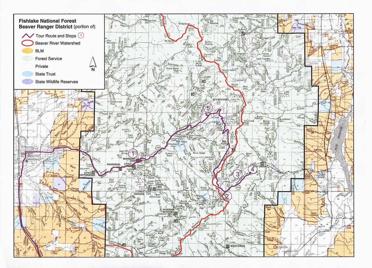
Tour 1: Fishlake National Forest, Beaver Ranger District
Points of Interest:
- Mahogany Cove , Beaver Canyon
- Gravel Pit at Betenson Flat
- Grindstone Flat enclosure
- Circleville look off
- Elk Meadows
Tour 2: Cedar Breaks
Points of Interest:
- Brianhead Peak
- Meadow Lake Estates
- Uinta Flat (Mammoth Cave)
- Cedar Breaks (Chessman Ridge)
- Zion Overlook (on Hwy 14)
- "C" Hill
- Cedar Mountain Aspen Decline
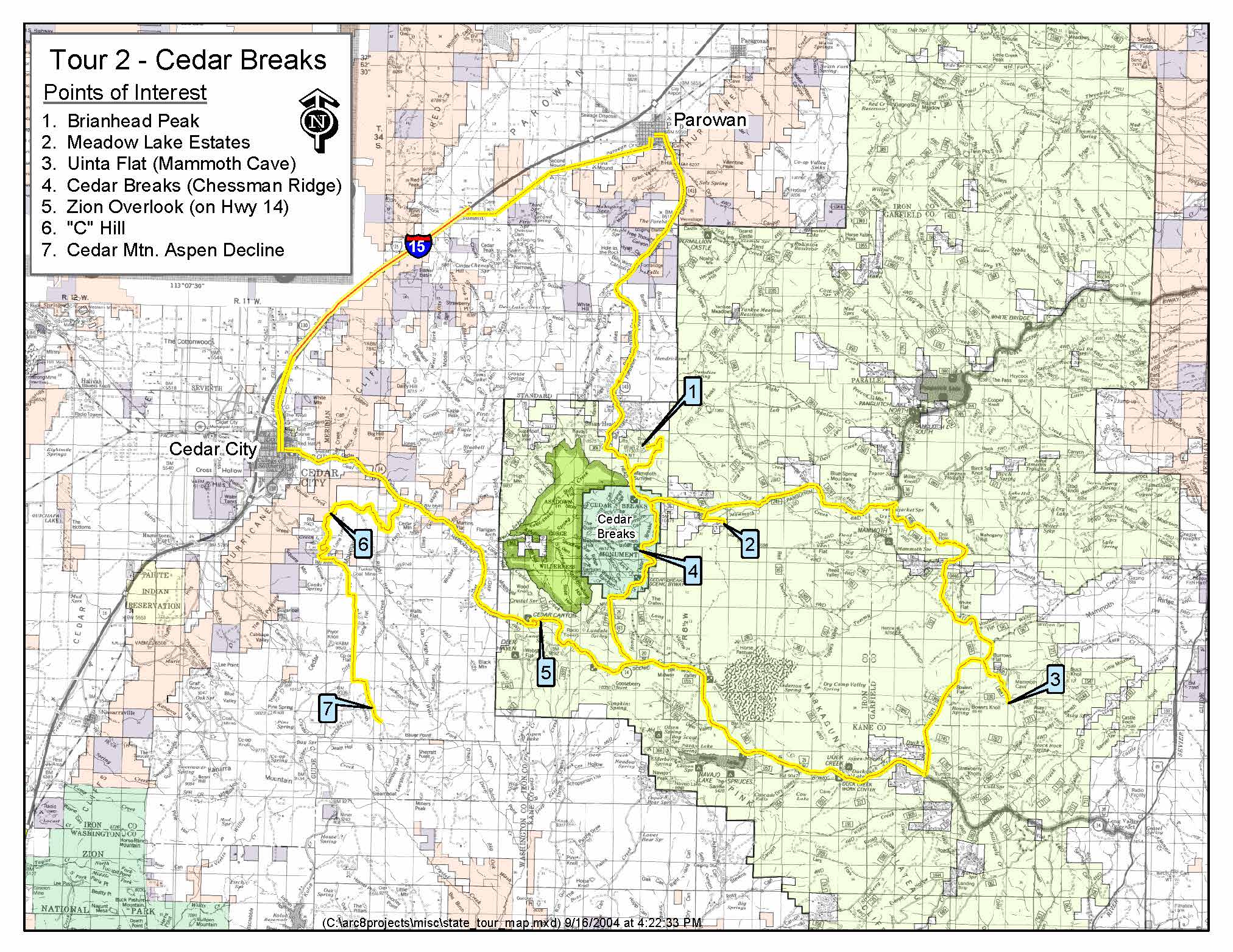
View a printable pdf version of the image.
Tour Handouts:
Southern Utah Forest Landowner Education Programs, Chad R. Reid, Clint Reese, James E. Bowns, and Michael R. Kuhns,
Additional Documents and Information
- Aspen Packet: A list of additional aspen related reading