Satellite-based Urban Evapotranspiration (ET) Estimation
Climate change and drought throughout the country are forcing irrigated urban landscapes to become more thrifty in how they use water. Understanding biophysical water demand is key to thrifty irrigated urban landscapes. Landscape water demand is the total amount of water a landscape uses from its root zone through soil evaporation and plant transpiration (landscape water use) over a season, punctuated by periodic irrigation to refill the landscape root zone before plant performance, based leaf hardiness to desiccation, degrades from water stress.
Measuring or estimating actual landscape plant water use is the cornerstone, foundation, and scaffolding for designing, regulating and managing water-thrifty urban landscapes. Currently, actual landscape plant water use is estimated from reference evapotranspiration, ETo. ETo defines water used by a hypothetical turfgrass surface based on solar radiation, air temperature, wind, and humidity for a given time period, then is adjusted downward for specific plant types.
Estimating Urban ET via Satellite
Estimating water use of individual landscapes from ETo of a hypothetical turfgrass surface and Plant Factors is fraught with uncertainty because the typical siting of a weather station used to calculate ETo is over large parks and golf courses. Landscape water use estimated over large turf areas are reasonably representative of other urban turfgrass landscape hydrozones, somewhat representative of woody plant landscape hydrozones, and marginally at best representative of desert plant hydrozones. Satellite-based remote sensing of urban vegetation cover has the potential to leapfrog the confines of the current ETo x Plant Factor approach.

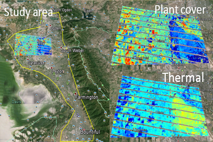
This figure shows the study area and sample plant cover and thermal images from Clinton, Utah. It shows a hot, non-vegetated Hill AFB and a cooler, more vegetated residential area; coolest pictures are large turf areas.
Two NASA satellites, Landsat and MODIS, take multispectral (multiple wavebands of light) images of any surface that can be used to calculate vegetation cover. These satellites also take thermal images of surface temperature. Surface plant cover and surface temperate of hot surfaces (like pavement) and cool surfaces (like evaporating-transpiring surfaces) are the raw ingredients for a recipe to measure actual surface evapotranspiration. Since urban areas have lots of transpiring, often irrigated, surfaces, but also lots of hot paved areas, using satellite images to to measure actual landscape water use has enormous potential. Our project is the first to apply satellite image analysis to measure landscape water use in urban areas. We aim to combine Landscape images collected every 8-14 days with MODIS images collected daily to estimate actual water use of large turf surfaces like parks and golf, but also estimate water use of the mosaic of smaller landscapes, thereby getting actual data on how urban plants use water, instead of guessing with ETo, that can be used to improve water management of urban landscapes.
Project Objective: Use Satellite-based ET to estimate actual conditions in urban microclimates

Satellite based ET offers the potential to estimate actual ET from urban oases. This information integrates specific site conditions and is not a reference of an idealized plant surface. The objective of this project would be to develop operational procedure to estimate actual evapotranspiration from a large, oasis urban turfgrass surface. This project aims to ultimately replace operational urban ET estimation by problematic weather stations (expensive, difficult to maintain, only gives hypothetical plant water use) with satellite-based estimation using the relationship between the range thermal pixels (hot pavement to cool turfgrass) and fractional plant cover.
The Problem: Agricultural Approach to Urban Landscape Irrigation
In the past, urban water management has adopted the irrigated agriculture approach. Due to the variability of microclimates that are found in urban areas, there are severe problems with this approach. The agricultural approach relies on weather data input (solar radiation, wind, temperature, humidity) to estimate a reference water use of standardized turf surface; then correct down (or up sometimes) based on plant types. The problem is that reference water use is based on oasis water use. Because of the special microclimates that are created by urban conditions, this weather data (temperature and light) does not match the actual site.
Irrigated urban landscapes have substantial value. For example, turfgrass is an estimated $35 Billion industry, urban landscapes provide 1 million jobs, and urban trees add 20% to property values. These urban landscapes rely on additional water through irrigation. However, water is limited in much of the western and southern U.S. In 2011, Texas lost 5 million urban trees to drought. Careful water management is required to maintain the urban green investment.
Projected Impact:
Building infrastructure to estimate actual water use by large urban turf areas (golf courses, parks, school ground) and operationally replace expensive and problematic ground weather stations. Reliable satellite-based operational ET estimates will save water when used in urban landscape planning and irrigation scheduling.
Outcome to Date:
We have contracted with the Utah Water Research Lab and the Space Dynamics Lab to develop procedures to capture and process satellite images (Landsat 7-14 days, high resolution and MODIS daily low resolution) into fractional plant cover and temperature data.