Creating Wildfire-Resilient Communities in Utah: Fuel Treatments in the Wildland-Urban Interface

Highlights
- For millennia, wildfires have helped maintain Utah’s ecosystems, with fires burning at relatively low severity.
- Decades of fire suppression, invasion of annual grasses, and climate change have led wildland fuels to accumulate and fire seasons to lengthen, causing modern wildfires to burn larger areas at higher severity.
- Fuel treatments, such as tree thinning, prescribed fire, herbicide application, and managed grazing, can lower fire severity and reduce wildfire risk to human developments and infrastructure.
In the western United States, decades of wildfire suppression and grazing have led to changes in the amount and type of wildland fuels. In many lower montane forests, fuels such as logs, dead trees, and fallen leaves have accumulated. In many sagebrush-dominated rangelands, annual grasses have invaded, and pinyon pine and juniper woodlands have encroached. These areas now threaten to burn at uncharacteristically high fire severity, a metric based on how much vegetation is killed. Climate change and rapid population growth have exacerbated this issue in Utah, increasing the threat wildfire poses to the state’s communities, infrastructure, and ecosystems. Fuel treatments have been shown to effectively lower fire severity and can reduce wildfire risk in Utah’s wildland-urban interface (WUI), where flammable wildlands border homes and buildings. Here, we review common impacts and risks of wildfire, the current state of fuel treatments in Utah, and how homeowners can protect their property.
Wildfire in Utah
For millennia, wildfire has played an important role in shaping Utah’s landscapes. Wildfires have helped maintain ecosystem health by increasing nutrient availability, promoting renewed plant growth, and supporting biodiversity (McGinty & McGinty, 2009). Between 1630 and 1900, wildfires occurred in at least 63% of years in Utah’s forests, which cover about 30% of the state (Brown et al., 2008; Birch & Lutz, 2023). These wildfires burned at relatively low severity, leaving behind trees that were damaged but grew scar tissue that could later be used to reconstruct the fire history of the area (Brown et al., 2008).
In contrast, modern wildfires in forests tend to be less frequent but more severe, especially when the wildfires are also large (Leenhouts, 1998; Murphy et al., 2018). These shifts in fire frequency, severity, and size can be attributed partly to effective wildfire suppression, which, since the 1950s, has drastically reduced how often areas are burned by wildfire in the western United States (Hagmann et al., 2021). Less disturbance by wildfire in forests has meant that trees, dead wood, and other plant material that would normally be consumed periodically by wildfire have accumulated, fueling modern wildfires to burn larger areas at higher severity (Hagmann et al., 2021; Graham et al., 2004). Longer, drier fire seasons have also resulted in a shift toward a small number of large wildfires making up most of the area burned in Utah each year (Birch & Lutz, 2023).
However, not all ecosystems in Utah have experienced the same changes in wildfire attributes. For example, sagebrush shrub–steppe covers about 20% of Utah and, between 1984 and 2022, represented over half of the area burned statewide by wildfires ≥100 acres (Birch & Lutz, 2023). Much of the sagebrush rangeland in western Utah has been invaded by annual grasses, such as cheatgrass, that form a continuous fuel bed (Boyd et al., 2024). These grasses desiccate in early summer, which can lead to larger, more frequent wildfires, despite fire suppression efforts (Baker, 2006; Birch & Lutz, 2023; Boyd et al., 2024). Conversely, patterns of wildfire occurrence in some areas and ecosystem types, such as high-elevation spruce-fir forests, are still similar to historical norms. But despite this stability, the risks posed by wildfires may have escalated in these areas due to expanding human development and infrastructure.
Although active fire suppression keeps most wildfires small, wildfires remain common in Utah (Figure 1). During 2002–2015, Utah experienced nearly 18,000 wildfires that burned a total of 2.5 million acres (Jakus et al., 2017). During 2022–2024, 3,015 wildfires were reported and, due largely to aggressive fire suppression, over 94% of these fires were contained before burning more than 10 acres (Table 1). Looking ahead, wildfire frequency and severity are expected to increase as climate change leads to longer fire seasons, drier fuel, greater tree mortality, and less soil moisture (Abatzoglou & Williams, 2016; Gergel et al., 2017; Utah Department of Public Safety, 2024). Recent climate change in Utah aligns with these expectations (Hotaling & Becker, 2024).
Table 1. From 2022 to 2024, Over 94% of Wildfires Were Suppressed in Utah
| Year | Number of wildfire ignitions | Wildfires >10 acres | Suppression rate (%) | Acres burned |
|---|---|---|---|---|
| 2022 | 963 | 51 | 94 | 25,551 |
| 2023 | 808 | 30 | 96 | 18,061 |
| 2024 | 1,244 | 89 | 93 | 90,660 |
| Sources: Utah Division of Forestry, Fire & State Lands (FFSL), 2022; FFSL, 2023; FFSL, 2024 | ||||
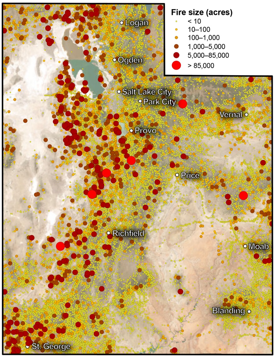
Data sources: InFORM Fire Occurrence Data Records, 2025; Short, 2022
Wildfire Impacts
Wildfires play an essential role in maintaining healthy ecosystems and resilient landscapes but can also put communities and their infrastructure at risk. Wildfires also pose a threat to lives, including those of the firefighters working to contain them (U.S. Fire Administration, 2025). Due to Utah’s growing population and increasing development in the WUI, the risks associated with wildfire are becoming harder to avoid (U.S. Census Bureau, 2024; Utah Department of Public Safety, 2024). The WUI is the area along a city’s perimeter where flammable forest and rangeland vegetation border urban structures (Toman et al., 2011). Homes built in the WUI are common in Utah and have high wildfire risk due to their proximity to wildland fuels (Utah Department of Public Safety, 2024). Accommodating Utah’s population growth also strains the critical infrastructure that provides water, energy, and other services to residents––and these sectors are highly susceptible to damage from wildfire (Utah Department of Public Safety, 2024).
The Utah Division of Forestry, Fire and State Lands has identified 80,000 homes in Utah that are in the WUI and at risk for wildfire (Flores, 2025; Wildfire Management in Utah, 2025). These homes are spread over 700 communities, and of these, 57 communities have a high likelihood of wildfire (≥80th percentile) and a high risk of home loss (≥85th percentile), similar to the Los Angeles communities that burned in the catastrophic wildfires of January 2025 (Figure 2; Headwaters Economics, 2025).
Wildfires also accelerate erosion, worsening water quality by suspending sediment in rivers. This eroded sediment can eventually be deposited in reservoirs, diminishing storage capacity (Olpin et al., 2025) and threatening fisheries (James et al., 2025). For example, post-wildfire erosion following the 2018 Dollar Ridge Fire threatened the water supply for 30,000 residents in the Uinta Basin, leading the Central Utah Water Conservancy District to spend $28 million to modify and protect the Duchesne Valley Water Treatment Plant (Central Utah Water Conservancy District, 2021; Weaver, 2019). Severe wildfires also alter the habitat of native species and worsen air quality, which can negatively impact animal and human health in the short and long term (Jakus et al., 2017; Snow, 2022).
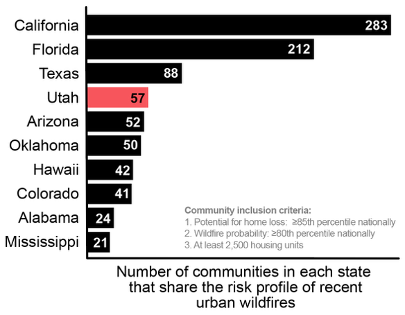
Figure redrawn from Headwaters Economics, 2025. Data source: Dillon et al., 2024
The threat wildfires pose to the state’s expanding population makes wildfire suppression a high priority for Utah. The Utah Wildfire Fund uses a combination of federal funding and state taxes and fees to support local fire departments and statewide fire prevention, preparedness, mitigation, suppression, and rehabilitation (Utah State Legislature, 2025). Fire suppression is expensive. Between 1999 and 2016, an average of $826,000 per fire was spent to suppress 450 fires ≥100 acres in Utah (Jakus et al., 2017). Over the past 40 years, wildfires have accounted for 39% of the total cost of billion-dollar weather and climate disasters in Utah (National Centers for Environmental Information, 2025). However, even with generous spending, total wildfire suppression is not possible. Fuel treatments that reduce fire severity near human developments and infrastructure can limit wildfire impacts while simultaneously encouraging a shift away from total suppression and toward coexistence with wildfire.
Fuel Treatments
Fire needs heat, oxygen, and fuel to burn, but only fuel can be managed to reduce wildfire risk (Kuhns & Daniels, 2012). The term “fuel treatment” refers to the practice of reducing the amount of combustible material (trees, shrubs, undergrowth) in an area to minimize damage from a potential wildfire (Graham et al., 2004). Fuel treatments are intended to mimic the natural effects of wildfire. Types of fuel treatments include (Reinhardt et al., 2008):
- Tree thinning or mastication (chipping of woody material).
- Prescribed burns.
- Herbicide application.
- Animal grazing.
Fuel treatments are effective at reducing wildfire severity, and––especially in forest ecosystems––can promote beneficial, low-severity wildfire over more destructive, high-severity events (Ott et al., 2023; Thompson, 2023; Brodie et al., 2024). Even where wildfires historically burned at high severity, fuel treatments can slow active wildfire spread, aiding suppression and containment efforts.
Fuel Treatments in Utah
State, county, and local governments, along with homeowners associations, collaborate to implement fuel treatments in Utah. However, because 63% of Utah’s land is owned by the federal government, most fuel treatments in Utah are implemented by federal agencies, especially the U.S. Forest Service (USFS) and Bureau of Land Management (BLM; Gorte et al., 2012). The USFS mostly manages forests, while the BLM typically manages rangelands and deserts (Gorte et al., 2012).
From 1997 to 2019, the USFS and BLM implemented 3,083 fuel treatments in Utah on nearly 1,200,000 acres (Figure 3; Thompson, 2023). Tree thinning was the most common treatment, both by area and number of treatments, followed by prescribed burns, then mastication. During the same period, over 3,250,000 acres of USFS and BLM land in Utah were burned by wildfires. Of the 3,083 fuel treatments, 8.7% were at least partly burned by these wildfires (Thompson, 2023). In treated areas, wildfires burned at lower average severity compared to untreated areas, and larger treatment areas were more likely to be at least partly burned by wildfire (Thompson, 2023). Thus, increasing the area of fuel treatments to maximize wildfire-treatment overlaps would allow more low-severity fires to provide their beneficial services at lower risk (Ott et al., 2023).

Source: Thompson, 2023
Protecting Your Home
While federal and state agencies have the greatest capacity for applying fuel treatments in Utah due to their large landholdings, individual homeowners can also take steps to protect their land and homes. Collectively, the efforts of residents, municipalities, and the state and federal government can combine to better protect Utahns from the negative effects of wildfire (Toman et al., 2011). This is especially important for homes in the WUI, where the threat of wildfire is high and effective fuel management can disrupt fuel continuity and prevent wildfires from expanding into urban areas (Kuhns & Daniels, 2012; Utah Department of Public Safety, 2024).
The principles of “firewise” landscaping can help minimize the risk of a home being damaged or destroyed by wildfire (Kuhns & Daniels, 2012). Generally, recommendations are to:
- Maintain space between trees and other vegetation in your yard.
- Keep grass less than 4 inches high.
- Choose plants that are not too tall, thick, or dry at any point during the fire season (June–October).
- Remove all fuels within 5 feet of your home.
For homeowners seeking additional information, check out these resources:
- Firewise Landscaping for Utah
- Prepare for Wildfire
- Utah Firewise Living
- Sagebrush, Wildfire, and Homeowners Associations: Opportunities for Adaptation
Acknowledgments
This publication was funded by the Utah Forest Restoration Institute (UFRI) and produced through a collaboration between the UFRI and Climate Adaptation Intern Program (CAIP) at Utah State University (USU). CAIP is supported by the “Secure Water Future” project, funded by a USDA Agriculture and Food Research Initiative Competitive Grant (#2021-69012-35916). CAIP is also supported by USU Extension, the USGS Southwest Climate Adaptation Science Center, and the USU Extension Water Initiative. We improved this fact sheet based on feedback from CAIP participants.
For correspondence, contact Scott Hotaling: scott.hotaling@usu.edu
References
- Abatzoglou, J. T., & Williams, A. P. (2016). Impact of anthropogenic climate change on wildfire across western US forests. Proceedings of the National Academy of Sciences of the United States of America, 113(42), 11770–11775. https://doi.org/10.1073/pnas.1607171113
- Baker, W. L. (2006). Fire and restoration of sagebrush ecosystems. Wildlife Society Bulletin (1973–2006), 34(1), 177–85. https://doi.org/10.2193/0091-7648(2006)34[177:FAROSE]2.0.CO;2
- Birch, J. D., & Lutz, J. A. (2023). Fire regimes of Utah: The past as prologue. Fire, 6(11), 423. https://doi.org/10.3390/fire6110423
- Boyd, C. S., Creutzburg, M. K., Kumar, A. V., Smith, J. T., Doherty, K. E., Mealor, B. A., Bradford, J. B., Cahill, M., Copeland, S. M., Duquette, C. A., Garner, L., Holdrege, M. C., Sparklin, B., & Cross, T. B. (2024). A strategic and science-based framework for management of invasive annual grasses in the sagebrush biome. Rangeland Ecology & Management, 97, 61–72. https://doi.org/10.1016/j.rama.2024.08.019
- Brodie, E. G., Knapp, E. E., Brooks, W. R., Drury, S. A., & Ritchie, M. W. (2024). Forest thinning and prescribed burning treatments reduce wildfire severity and buffer the impacts of severe fire weather. Fire Ecology, 20(1), 1–20. https://doi.org/10.1186/s42408-023-00241-z
- Brown, P. M., Heyerdahl, E. K., Kitchen, S. G., & Weber, M. H. (2008). Climate effects on historical fires (1630–1900) in Utah. International Journal of Wildland Fire, 17, 28–39. https://doi.org/10.1071/wf07023
- Central Utah Water Conservancy District. (2021, November 3). https://cuwcd.gov/posts/20211103-catastrophic-wildfire-mitigation.html#gsc.tab=0
- Dillon, G. K., Lazarz, M. T., Karau, E. C., Story, S. J., & Pohl, K. A. (2024). Wildfire Risk to Communities: Community Wildfire Risk Reduction Zones for the United States. Forest Service Research Data Archive. https://doi.org/10.2737/RDS-2024-0030
- Flores, C. (2025, July 8). Utah to inspect up to 80,000 homes for wildfire risk, homeowners will pay for program fee. KUTV. https://kutv.com/news/eye-on-your-money/utah-to-inspect-up-to-80000-homes-for-wildfire-risk-homeowners-will-pay-for-program-fee
- Gergel, D. R., Nijssen, B., Abatzoglou, J. T., Lettenmaier, D. P., & Stumbaugh, M. R. (2017). Effects of climate change on snowpack and fire potential in the western USA. Climatic Change, 141, 287–299. https://doi.org/10.1007/s10584-017-1899-y
- Gorte, R. W., Hanson, L. A., Vincent, C. H., & Rosenblum, M. R. (2012). Federal land ownership: Overview and data (R42346). Congressional Research Service. https://www.congress.gov/crs-product/R42346
- Graham, R. T., McCaffrey, S., & Jain, T. B. (2004). Science basis for changing forest structure to modify wildfire behavior and severity (RMRS-GTR-120). United States Department of Agriculture, Forest Service, Rocky Mountain Research Station. https://doi.org/10.2737/RMRS-GTR-120
- Hagmann, R. K., Hessburg, P. F., Prichard, S. J., Povak, N. A., Brown, P. M., Fulé, P. Z., Keane, R. E., Knapp, E. E., Lydersen, J. M., Metlen, K. L., Reilly, M. J., Sánchez Meador, A. J., Stephens, S. L., Stevens, J. T., Taylor, A. H., Yocom, L. L., Battaglia, M. A., Churchill, D. J., Daniels, L. D., Falk, D. A., … Waltz, A. E. M. (2021). Evidence for widespread changes in the structure, composition, and fire regimes of western North American forests. Ecological Applications, 31(8), e02431. https://doi.org/10.1002/eap.2431
- Headwaters Economics. (2025, February 26). America’s urban wildfire crisis: More than 1,100 communities at risk. https://headwaterseconomics.org/wildfire/more-than-1100-communities-urban-wildfire-risk/
- Hotaling, S., & Becker, K. M. L. (2024). Recent climate change in Utah, 1870–2023 [Fact sheet]. Utah State University Extension. https://digitalcommons.usu.edu/cgi/viewcontent.cgi?article=3473&context=extension_curall
- InFORM Fire Occurrence Data Records. (2025, September 10). Incident records for all known fire occurrence in the United States shown as point locations. https://nifc.maps.arcgis.com/home/item.html?id=60a94840152b4a89bec467a9f052f135
- Jakus, P. M., Kim, M., Martin, R. S., Hammond, I., Hammill, E., Mesner, N. O., & Stout, J. (2017). Wildfire in Utah: The physical and economic consequences of wildfire [Paper 1002]. Watershed Sciences Faculty Publications, Utah State University. https://digitalcommons.usu.edu/wats_facpub/1002
- James, C., Becker, K. M. L., Hotaling, S., Chandrasekaran, A., Fielder, A., Walsworth, T. E., & Belmont, P. (2025). Post-wildfire erosion and sedimentation: An escalating threat for Utah's fisheries [Fact sheet]. Utah State University Extension. https://digitalcommons.usu.edu/cgi/viewcontent.cgi?article=3549&context=extension_curall
- Kuhns, M., & Daniels, B. (2012, December). Firewise landscaping for Utah. Utah State University Cooperative Extension. https://www.slc.gov/fire/wp-content/uploads/sites/47/2019/04/FirewiseLandscaping2012.pdf
- Leenhouts, B. (1998). Assessment of biomass burning in the conterminous United States. Conservation Ecology, 2(1), 1. https://www.consecol.org/vol2/iss1/art1/
- McGinty, E. I. L., & McGinty, C. (2009). Rangeland resources of Utah: Fire in Utah. https://extension.usu.edu/rangelands/files/RRU_Final.pdf
- Murphy, B. P., Yocom, L. L., & Belmont, P. (2018). Beyond the 1984 perspective: Narrow focus on modern wildfire trends underestimates future risks to water security. Earth’s Future, 6(11), 1492–1497. https://doi.org/10.1029/2018EF001006
- National Centers for Environmental Information. (2025). U.S. billion-dollar weather and climate disasters. National Oceanic and Atmospheric Administration. https://www.ncei.noaa.gov/access/billions/state-summary/UT
- Olpin, Q., Becker, K. M. L., Hotaling, S., Chandrasekaran, A., & Belmont, P. (2025). Wildfire and water security: Post-fire erosion and sedimentation threaten Utah's reservoirs [Fact sheet]. Utah State University Extension. https://digitalcommons.usu.edu/cgi/viewcontent.cgi?article=3551&context=extension_curall
- Ott, J. E., Kilkenny, F. F., & Jain, T. B. (2023). Fuel treatment effectiveness at the landscape scale: A systematic review of simulation studies comparing treatment scenarios in North America. Fire Ecology, 19(1), 10. https://doi.org/10.1186/s42408-022-00163-2
- Reinhardt, E. D., Keane, R. E., Calkin, D. E., & Cohen, J. D. (2008). Objectives and considerations for wildland fuel treatment in forested ecosystems of the interior western United States. Forest Ecology and Management, 256(12), 1997–2006. https://doi.org/10.1016/j.foreco.2008.09.016
- Short, K. C. (2022). Spatial wildfire occurrence data for the United States, 1992–2020 [FPA_FOD_20221014], 6th edition. Forest Service Research Data Archive. https://doi.org/10.2737/RDS-2013-0009.6
- Snow, M. (2022, October 7). How does wildfire impact wildlife and forests? U.S. Fish & Wildlife Service. https://www.fws.gov/story/2022-10/how-does-wildfire-impact-wildlife-and-forests
- Thompson, J. (2023). A statewide evaluation of fuel treatment effectiveness in altering wildfire outcomes on public lands in Utah (Publication No. 8858) [Master’s thesis, Utah State University]. Digital Commons. https://doi.org/10.26076/66e6-83a6
- Toman, E., Stidham, M., Shindler, B., & McCaffrey, S. (2011). Reducing fuels in the wildland–urban interface: Community perceptions of agency fuels treatments. International Journal of Wildland Fire, 20(3), 340–349. https://doi.org/10.1071/WF10042
- U.S. Census Bureau. (2024, December). Net international migration drives highest U.S. population growth in decades. https://www.census.gov/newsroom/press-releases/2024/population-estimates-international-migration.html
- U.S. Fire Administration. (2025, March 24). Utah fire loss and fire department profile. Federal Emergency Management Agency. https://www.usfa.fema.gov/statistics/states/utah.html
- Utah Department of Public Safety. (2024). Utah enhanced state hazard mitigation plan. https://acrobat.adobe.com/link/review?uri=urn%3Aaaid%3Ascds%3AUS%3Aaeb42438-0dd3-3303-9fec-e773c50a4709
- Utah Division of Forestry, Fire and State Lands (FFSL). (2022). Utah wildfire annual report. https://ffsl.utah.gov/wp-content/uploads/2022-Utah-Wildfire-Summary.pdf
- FFSL. (2023). Utah wildfire annual report. https://ffsl.utah.gov/wp-content/uploads/2023_UtahWildfireSummary_FINAL.pdf
- FFSL. (2024). Utah wildfire annual report. https://ffsl.utah.gov/wp-content/uploads/UtahWildfireSummary_Final-1132025-1.pdf
- Utah State Legislature. (2025, July 11). Fireproof funding: Recent changes in Utah’s wildfire budget. https://budget.utah.gov/fireproof-funding/
- Weaver, J. (2019, November 18). Wildfire's impact in Duchesne County goes beyond homes in direct path of blaze. KUTV. https://kutv.com/news/local/wildfires-impact-in-duchesne-county-goes-beyond-homes-in-direct-path-of-blaze
- Wildfire Management in Utah. (2025, June 1). Strengthening the state’s wildfire preparedness, a report in response to Executive Order 2025–03. https://governor.utah.gov/wp-content/uploads/Final-Wildfire-Management-Report.pdf
September 2025
Utah State University Extension
Authors
Luke Dutson1, Kendall Becker1,2, Katlyn Stemmler2, J. Bradley Washa3, Larissa L. Yocom3, Aish Chandrasekaran4, Joseph D. Birch5, Scott Hotaling1,2
1Utah State University (USU) Climate Adaptation Intern Program
2USU Department of Watershed Sciences
3USU Department of Wildland Resources
4USU Department of Environment and Society
5University of Idaho Department of Forest, Rangeland and Fire Sciences
Bradley Washa
Assistant Professor of Wildland Fire Science
Wildland Resources
Scott Hotaling
Assistant Professor | Climate Resiliency Specialist
Watershed Sciences
Related Research