UPCOMING EVENTS
View full calendarUtah Major Watersheds
WHERE DOES UTAH GET ITS WATER?
Most of the water that Utah receives comes from precipitation, and much of this precipitation comes from snow. Utah's water supply varies greatly across the state. Mountain areas can receive as much as 50 inches of precipitation a year, while desert areas can receive less than 10 inches.

HOW DOES UTAH USE ITS WATER?
Most of Utah's water (about 79.2%), goes towards agricultural use. The rest is used by cities and towns (about 9%) and industries (about 4%). For more on how water is used within those categories, click here. Much of the water comes from precipitation stored in reservoirs, so if we don't receive sufficient precipitation to fill those reservoirs, crop production falls and some communities are forced to put restrictions on water use. Since Utah is growing so quickly, they have had to start looking into using another form of stored water called ground water.
UTAH'S MAJOR WATERSHEDS
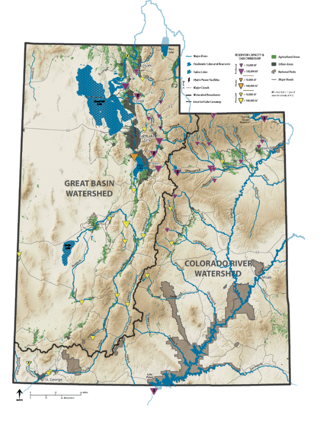
The state of Utah belongs mostly to 2 bigger watersheds, the Great Basin and the Upper Colorado. Also a slight piece of the Lower Colorado River watershed extends into Southern Utah, and the Columbia River Basin takes up a small chunk of the northwestern corner of the state. Click the map to the left for a better breakdown. The Colorado River watershed drains into the Sea of Cortez in Mexico, but the Great Basin watershed has no outlets and terminates in inland water bodies like the Great Salt Lake. It is the only major watershed in the United States that doesn't drain into an ocean.
10 WATERSHED MANAGEMENT UNITS
Since watersheds do not follow county, municipal or state lines, these 10 units were designated as the statewide watershed management units. Each of these watersheds is unique and has its own projects and concerns. To learn more about specific projects in your watershed, click on a watershed above. It will take you to the Utah Clean Water Partnership website.

WATERSHED BOUNDARIES
Watersheds don't usually follow state lines. This is especially true in Utah as can be seen in the map below.

The map below is from the U.S. Geological Survey (USGS) and shows how across the nation,
most watershed boundaries do not follow state boundaries. Some state boundaries, like
the Nevada-California border and the border of New York with Massachusetts and Connecticut,
line up perfectly with watershed boundaries; but the majority are like Utah where
the state boundaries have little or nothing to do with the watershed boundaries.