Pink Rock Quarry
1948
1953
2005
Description:
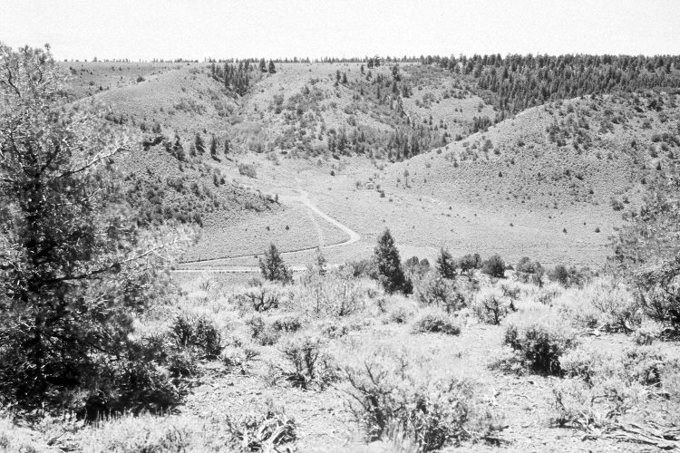
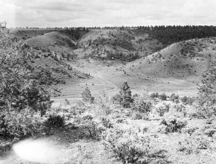
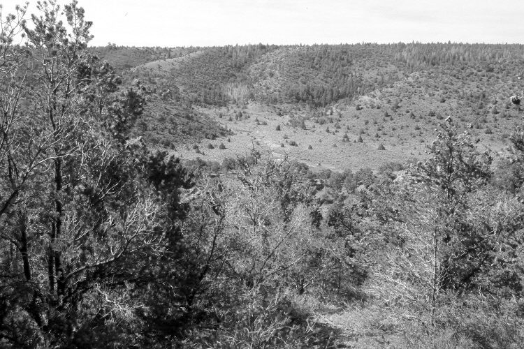
Plate 1036X. Pink Rock Quarry 1948 – 1953 – 2005 The Pink Rock Quarry Photo Plot Transect was established by the Forest Service in 1943 to monitor range conditions on Dickinson Hill above South Canyon. The transect is 2,100 feet in length and according to early narrative reports, the area was very heavily grazed by domestic sheep when monitoring began. “The entire area shows serious soil depletion. [Erosion] pavement is everywhere…and top soil is found only under the protection of trees and shrubs…All grasses, excepting Bouteloua [blue gramma], are found only in the protection of shrubs…[A few Utah serviceberry] appear on the south ridge [and are all] in a very poor state of vigor. They are badly hedged and over half of the branches dead.” After remeasuring the transect in 1948, W.P. Cottam reported there had been “little improvement” since monitoring began and recommended that “lambing on this area should be discontinued.” While in 1953, I.H. Johnson noted that “the allotment continues to be used as lambing range, the ‘dropping’ herd now grazing the area along the transect line. This use has resulted in considerable soil disturbance…and many plants [are pedestaled] three to four inches high, indicative of the heavy soil loss…this range is in such extremely poor condition is doesn’t seem possible that it could deteriorate further.” Johnson also observed that pinyon and juniper were starting to invade the area. In 1979, Dr. Jim Bowns reported continued pinyon/juniper invasion and cautioned that “it is highly unlikely that this allotment will improve without some type of mechanical treatment or fire.” Plate 1036x is viewed southwest from the end of the Photo Plot Transect. Utah Highway 143 runs from left to right up South Canyon. The original camera station is blocked by a dense growth of pinyon and juniper, so the 2005 retake was made from the nearest open area. Conifers, including pinyon, juniper, ponderosa pine, and Douglas fir, have increased in the distance, while aspen has declined. Curlleaf mountain mahogany has also increased.
Photo Information:
U.S. Forest Service photographs (unnumbered) taken by W.P. Cottam on August 16, 1948, and by I.H. Johnson on June 6, 1953; retake by Charles E. Kay on August 5, 2005 - - Photo No. 5516-32. Original photographs, negatives, and narrative reports held in the range files on the Cedar City Ranger District, Dixie National Forest, Cedar City, UT.
Vegetative Community:
Pinyon, Juniper, Conifer, Aspen, Mountain Brush
Location:
South West: Section 15, Range 6 West, Township 35 South; UTM of the transect starting point 366900 E, 4181400 N; elevation 8,000 ft.