Panguitch Lake Guard Station
1936
2005

Description:
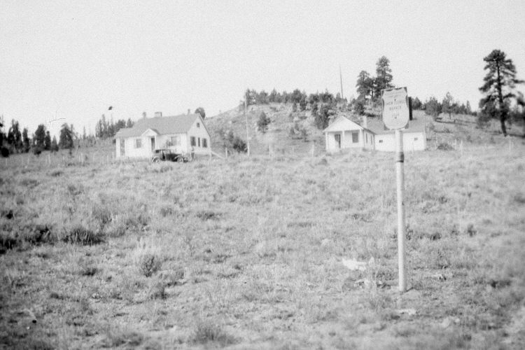
Plate 1023X. Panguitch Lake Guard Station 1936 – 2005 Viewed southwest to the Forest Service Guard Station at Panguitch Lake - - see Plate 1015x. The steel post and sign in the 1936 image mark the start of the old snow survey course at Panguitch Lake. In 1936, a series of snow courses were established throughout southern Utah by what is today the Natural Resources Conservation Service (NRCS). When they were first set-up, photographs were taken at each snow survey site. Although the snow course at Panguitch Lake is no longer used by NRCS, the photos remain. Ponderosa pine, spruce ,and aspen have been planted around the buildings, but conifers have also increased on the rest of the hillside where they were not planted. Buildings on the right and left have been removed, but the one in the center is visible in the retake. A paved, West Side Road has been built between the wooden rail fence and the photopoint, but is largely hidden from view by the lush vegetation. Smooth brome and Great Basin wild rye (photo left) line the edge of the road, while mountain big sage, three-tipped sage, and needle and thread are the most common species in the foreground. Also see Plates 1027x and 1028x.
Photo Information:
Original photograph (NRCS – 196) taken on September 9, 1936; retake by Charles E. Kay on August 3, 2005 - - Photo No. 5511-19. Original photograph held by the Snow Survey Supervisor, Natural Resources Conservation Service, Salt Lake City, UT.
Vegetative Community:
Conifer, Aspen, Sagebrush
Location:
South West: Section 5, Range 7 West, Township 36 South; UTM 354600 E, 4174250 N; elevation 8,240 ft.