Mcgath Lake
1872
1996
Description:
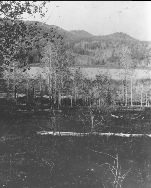
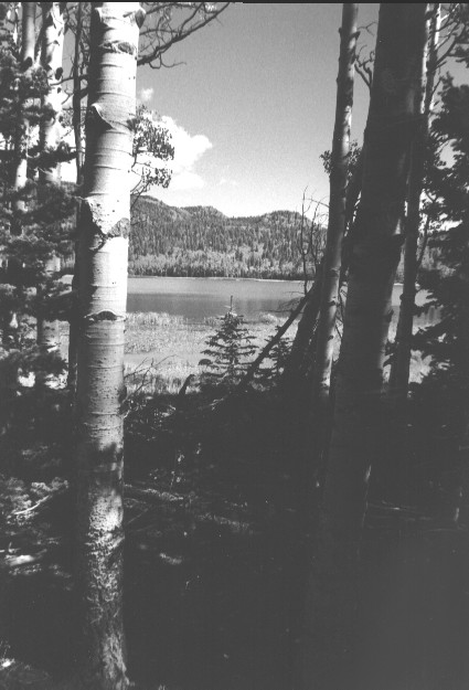
Plate 30. McGATH LAKE : 1872 - 1996 The 1872 photo shows a multi-aged, regenerating aspen (Populus tremuloides) community between the camera and the lake. The vegetation in the 1872 photo had never been grazed by livestock, as this area was not settled until after the photo was taken. The aspen show no sign of browsing by either deer or elk, unlike today, which suggests that present wildlife numbers do not reflect historical condition. The 1872 photo point could not be precisely relocated because a dense forest has since become established in the absence of the frequent, low-intensity fires that once swept this area. By 1996 the aspen trees matured and have been invaded by conifers, primarily spruce (Picea sp.) and subalpine fir (Abies lasiocarpa). The 1996 photos, made at 100, 50, 25, and 0 feet from the lake shore, illustrate how the forest has grown. Across the lake the conifers in the 1872 photo were primarily Douglas-fir (Pseudotsuga menziesii) and spruce (Picea sp.) that apparently survived repeated non-crown fires, as judged by the interspersed regenerating aspen. Many of those trees grew on rocky outcrops where the sparse ground cover limited the spread of fire. By 1996, however, these hillsides were covered with dense growths of regenerating conifers, primarily spruce and subalpine fir, which would support high-intensity stand-replacing, crown fires which were unlikely in the past. An irrigation dam raised the lake level and drowned much of the original riparian vegetation, especially the willow (Salix spp.) communities present on the far shore.
Photo Information:
1872 photo [#526] taken by John Hillers; 1996 photos are Kay #4058-12, #4058-20, #4058-25, and #4058-28 taken on Sept, 16. Hillers’ photo [RG-057-PS] held by the National Archives, Washington D.C.
Vegetative Community:
Aspen, Conifer, Riparian
Location:
South Central: On Boulder Mountain, T32S, R3E., Sect. 28, UTM 4205700 N, 449850 E; elevation 9,380 ft.; view to northeast.