Below Road Canyon
ca. 1938

1998
Description:
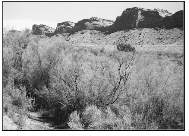
BELOW ROAD CANYON The view is north northeast across at a point about 1.5 miles south of where Road Creek enters . The repeat photograph was actually taken some 300 feet south and 90 feet west of the Hopkins photograph. The move was necessary to secure a view of the scene through dense tamarisk plants on the floodplain terrace. The surrounding land is BLM administered. The 1938 photograph shows a pack string ascending a wide, shallow, and braided channel with no riparian vegetation. In 1998 the channel was a single stem with several overflow channels. Three floodplains have now developed and the top two are vegetated primarily by tamarisk and a few cottonwood trees at this location. However, the streambank and first terrace contain a good variety of native riparian plant species, including, cottonwood seedlings and poles, coyote willow, bulrush, rush species, horsetail, saltgrass and scratchgrass. Bermuda grass, an introduced specie, is also found on the banks. Stream channel and vegetation conditions in 1998 are a vast improvement over conditions found in 1938. However, is intermittent at this location and further riparian development will be slow. Three historic photographs from 1910, 1928 and 1938 along indicate similar vegetation and channel conditions during those years. Improvements occurred after 1938.
Photo Information:
Photograph Number: Hopkins No. 1 Click here to view photograph Original: Date: ca. 1938 (- A) Photographer: W.H. Hopkins Source: U.S. Geological Survey Professional Paper no. 188, 1938 Retake: Date: September 16, 1998 Photographer: Earl Hindley Source: San Juan County
Vegetative Community:
Riparian
Location:
San Juan: SE1/4SE1/4 Section 12 T.40S., R.20E.